![](/images/other/stat-length.png)
![Excursión A pie Cagnes-sur-Mer - GRP XYZ 1 - Photo](https://media.geolcdn.com/t/1900/400/ext.pjpeg?maxdim=2&url=https%3A%2F%2Fstatic1.geolcdn.com%2Fsiteimages%2Fupload%2Ffiles%2F1545311037marcheuse_200dpi.jpg)
GRP XYZ 1
REYPatrick
Usuario
![Longitud](/images/other/stat-length.png)
Longitud
55 km
![Altitud máxima](https://static1.geolcdn.com/siteimages/upload/files/1508320355ic_sort_altitude_max_24dp.png)
Altitud máxima
348 m
![Desnivel positivo](https://static1.geolcdn.com/siteimages/upload/files/1508320355ic_sort_den_pos_24dp.png)
Desnivel positivo
1433 m
![Km-Effort](/images/other/stat-length.png)
Km-Effort
74 km
![Altitud mínima](https://static1.geolcdn.com/siteimages/upload/files/1508320355ic_sort_altitude_min_24dp.png)
Altitud mínima
0 m
![Desnivel negativo](https://static1.geolcdn.com/siteimages/upload/files/1508320355ic_sort_den_neg_24dp.png)
Desnivel negativo
1433 m
![Boucle](https://static1.geolcdn.com/siteimages/upload/files/16400158638029165_repeat_loop_refresh_sync_direction_icon.png)
Boucle
Sí
Fecha de creación :
2020-02-03 09:44:56.06
Última modificación :
2020-03-04 15:17:44.171
![A pie](https://static1.geolcdn.com/sitytour/trail-icons/100.png)
92h00
Dificultad : Medio
![Escanee este código QR para abrir la excursión en la aplicación SityTrail](https://capi.geolives.com/qq0zvz2zws4bq2lad0pu/sitytour/trails/2322683/qr.png?size=200)
Aplicación GPS de excursión GRATIS
A propósito
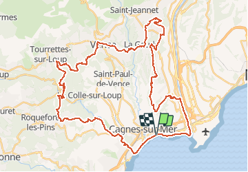
Ruta A pie de 55 km a descubrir en Provenza-Alpes-Costa Azul, Alpes Marítimos, Cagnes-sur-Mer. Esta ruta ha sido propuesta por REYPatrick.
Descripción
Cagnes sur Mer, Villeneuve loubet, Roquefort, La colle sur Loup, Tourette sur Loup, Vence, Saint Laurent du Var, Saint Paul de Vence.
Localización
País:
France
Región :
Provenza-Alpes-Costa Azul
Departamento/provincia :
Alpes Marítimos
Municipio :
Cagnes-sur-Mer
Localidad:
Unknown
Salida:(Dec)
Salida:(UTM)
352082 ; 4835418 (32T) N.
Comentarios
Excursiones cerca
![Excursión Senderismo Villeneuve-Loubet - plateau montmeuil - Photo](https://media.geolcdn.com/t/375/260/ext.jpg?maxdim=2&url=https%3A%2F%2Fstatic1.geolcdn.com%2Fsiteimages%2Fupload%2Ffiles%2F1553511878bg_sport_marche.png)
![Senderismo Senderismo](https://static1.geolcdn.com/sitytour/trail-icons/101.png)
plateau montmeuil
Senderismo
Medio
(1)
Villeneuve-Loubet,
Provenza-Alpes-Costa Azul,
Alpes Marítimos,
France
![](/images/other/stat-length.png)
7,3 km | 8,9 km-effort
2h 27min
![](https://static1.geolcdn.com/siteimages/upload/files/16400158638029165_repeat_loop_refresh_sync_direction_icon.png)
No
![Excursión Senderismo Villeneuve-Loubet - Parc departemental des Rives du Loup. - Photo](https://media.geolcdn.com/t/375/260/ext.jpg?maxdim=2&url=https%3A%2F%2Fservices.sitytrail.com%2FGeolivesWS%2FDownloadMedia.ashx%3FTrailID%3D464702%26Media%3Dfix__20150827152618.jpg)
![Senderismo Senderismo](https://static1.geolcdn.com/sitytour/trail-icons/101.png)
Parc departemental des Rives du Loup.
Senderismo
Muy fácil
Villeneuve-Loubet,
Provenza-Alpes-Costa Azul,
Alpes Marítimos,
France
![](/images/other/stat-length.png)
6,9 km | 8 km-effort
1h 23min
![](https://static1.geolcdn.com/siteimages/upload/files/16400158638029165_repeat_loop_refresh_sync_direction_icon.png)
Sí
![Excursión Senderismo Cagnes-sur-Mer - Villeneuve Loubet - Photo](https://media.geolcdn.com/t/375/260/3697ac0e-a76a-452a-a0b6-1b4fef9af2a0.jpg&format=jpg&maxdim=2)
![Senderismo Senderismo](https://static1.geolcdn.com/sitytour/trail-icons/101.png)
Villeneuve Loubet
Senderismo
Fácil
Cagnes-sur-Mer,
Provenza-Alpes-Costa Azul,
Alpes Marítimos,
France
![](/images/other/stat-length.png)
13,3 km | 15,7 km-effort
6h 40min
![](https://static1.geolcdn.com/siteimages/upload/files/16400158638029165_repeat_loop_refresh_sync_direction_icon.png)
Sí
![Excursión Marcha nórdica La Colle-sur-Loup - le long du Loup - Photo](https://media.geolcdn.com/t/375/260/323a9641-ff90-4c05-8bfa-f94db62a990b.jpg&format=jpg&maxdim=2)
![Marcha nórdica Marcha nórdica](https://static1.geolcdn.com/sitytour/trail-icons/102.png)
le long du Loup
Marcha nórdica
Medio
La Colle-sur-Loup,
Provenza-Alpes-Costa Azul,
Alpes Marítimos,
France
![](/images/other/stat-length.png)
8,9 km | 10,3 km-effort
1h 54min
![](https://static1.geolcdn.com/siteimages/upload/files/16400158638029165_repeat_loop_refresh_sync_direction_icon.png)
No
![Excursión Senderismo Villeneuve-Loubet - villeu - Photo](https://media.geolcdn.com/t/375/260/f934ad61-da42-41d4-aa37-c20917057afa.jpg&format=jpg&maxdim=2)
![Senderismo Senderismo](https://static1.geolcdn.com/sitytour/trail-icons/101.png)
villeu
Senderismo
Difícil
Villeneuve-Loubet,
Provenza-Alpes-Costa Azul,
Alpes Marítimos,
France
![](/images/other/stat-length.png)
8,7 km | 12,4 km-effort
2h 11min
![](https://static1.geolcdn.com/siteimages/upload/files/16400158638029165_repeat_loop_refresh_sync_direction_icon.png)
No
![Excursión Senderismo Villeneuve-Loubet - vill - Photo](https://media.geolcdn.com/t/375/260/c73938c8-47b2-46e8-b11d-c2bd9e4c64b0.jpg&format=jpg&maxdim=2)
![Senderismo Senderismo](https://static1.geolcdn.com/sitytour/trail-icons/101.png)
vill
Senderismo
Fácil
Villeneuve-Loubet,
Provenza-Alpes-Costa Azul,
Alpes Marítimos,
France
![](/images/other/stat-length.png)
10,3 km | 14,2 km-effort
3h 40min
![](https://static1.geolcdn.com/siteimages/upload/files/16400158638029165_repeat_loop_refresh_sync_direction_icon.png)
Sí
![Excursión Senderismo Villeneuve-Loubet - villeneuve loubet - Photo](https://media.geolcdn.com/t/375/260/8c9d478a-bff7-41c4-a3a9-5e72c54f5883.jpg&format=jpg&maxdim=2)
![Senderismo Senderismo](https://static1.geolcdn.com/sitytour/trail-icons/101.png)
villeneuve loubet
Senderismo
Fácil
Villeneuve-Loubet,
Provenza-Alpes-Costa Azul,
Alpes Marítimos,
France
![](/images/other/stat-length.png)
10,3 km | 14,1 km-effort
5h 30min
![](https://static1.geolcdn.com/siteimages/upload/files/16400158638029165_repeat_loop_refresh_sync_direction_icon.png)
Sí
![Excursión Senderismo Villeneuve-Loubet - Villeneuve Loubet -Marquisat - Photo](https://media.geolcdn.com/t/375/260/a83e40c8-4ef5-4a36-9725-830025757948.jpg&format=jpg&maxdim=2)
![Senderismo Senderismo](https://static1.geolcdn.com/sitytour/trail-icons/101.png)
Villeneuve Loubet -Marquisat
Senderismo
Muy fácil
Villeneuve-Loubet,
Provenza-Alpes-Costa Azul,
Alpes Marítimos,
France
![](/images/other/stat-length.png)
11,5 km | 15,6 km-effort
3h 39min
![](https://static1.geolcdn.com/siteimages/upload/files/16400158638029165_repeat_loop_refresh_sync_direction_icon.png)
No
![Excursión Bici de montaña Villeneuve-Loubet - vaigre nier marion - Photo](https://media.geolcdn.com/t/375/260/ext.jpg?maxdim=2&url=https%3A%2F%2Fservices.sitytrail.com%2FGeolivesWS%2FDownloadMedia.ashx%3FTrailID%3D133935%26Media%3D20120615154105.jpg)
![Bici de montaña Bici de montaña](https://static1.geolcdn.com/sitytour/trail-icons/202.png)
vaigre nier marion
Bici de montaña
Muy fácil
Villeneuve-Loubet,
Provenza-Alpes-Costa Azul,
Alpes Marítimos,
France
![](/images/other/stat-length.png)
11,6 km | 13,2 km-effort
1h 29min
![](https://static1.geolcdn.com/siteimages/upload/files/16400158638029165_repeat_loop_refresh_sync_direction_icon.png)
Sí