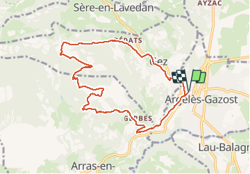
![](/images/other/stat-length.png)
![Excursión Senderismo Argelès-Gazost - ARGELES Mont de Gez G3 fait - Photo](https://media.geolcdn.com/t/1900/400/653c1198-5439-4c4b-acf2-a53537be36e4.jpg&format=pjpeg&maxdim=2)
ARGELES Mont de Gez G3 fait
marmotte65
Usuario GUIDE
![Longitud](/images/other/stat-length.png)
![Altitud máxima](https://static1.geolcdn.com/siteimages/upload/files/1508320355ic_sort_altitude_max_24dp.png)
![Desnivel positivo](https://static1.geolcdn.com/siteimages/upload/files/1508320355ic_sort_den_pos_24dp.png)
![Km-Effort](/images/other/stat-length.png)
![Altitud mínima](https://static1.geolcdn.com/siteimages/upload/files/1508320355ic_sort_altitude_min_24dp.png)
![Desnivel negativo](https://static1.geolcdn.com/siteimages/upload/files/1508320355ic_sort_den_neg_24dp.png)
![Boucle](https://static1.geolcdn.com/siteimages/upload/files/16400158638029165_repeat_loop_refresh_sync_direction_icon.png)
![Senderismo](https://static1.geolcdn.com/sitytour/trail-icons/101.png)
5h39
Dificultad : Medio
![Escanee este código QR para abrir la excursión en la aplicación SityTrail](https://capi.geolives.com/qq0zvz2zws4bq2lad0pu/sitytour/trails/2320497/qr.png?size=200)
Aplicación GPS de excursión GRATIS
A propósito
Ruta Senderismo de 10,2 km a descubrir en Occitania, Altos-Pirineos, Argelès-Gazost. Esta ruta ha sido propuesta por marmotte65.
Descripción
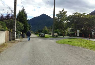
malgré les 11 km et les 600 M cette ballade est a mon avis accessible a toute personne qui a un minimum de condition physique la montée régulière sur 6km est avalée facilement, et si le ciel est bleu que du bonheur en arrivant en haut.
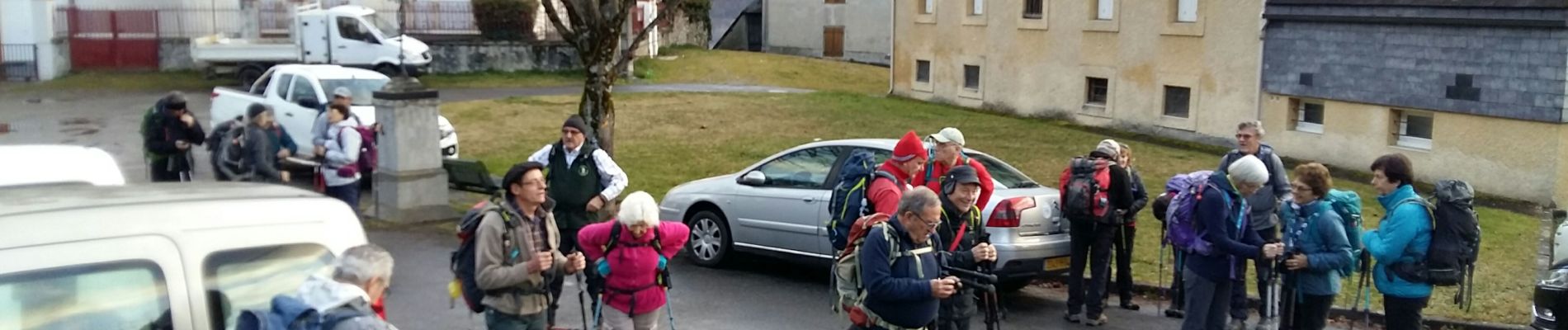
départ du parking derrierela maison de retraite de Caneri à 9h sans forcer vous serez au mont de Gez a 12 h pour un PN bien mérité et un point de vue..............Allez y
Localización
Comentarios
Excursiones cerca
![Excursión Senderismo Arcizans-Dessus - la fontaine de Nabias - Photo](https://media.geolcdn.com/t/375/260/7a92cfc2-a248-4e38-88ec-b8751d1d13fa.jpg&format=jpg&maxdim=2)
![Senderismo Senderismo](https://static1.geolcdn.com/sitytour/trail-icons/101.png)
Senderismo
![](/images/other/stat-length.png)
![](https://static1.geolcdn.com/siteimages/upload/files/16400158638029165_repeat_loop_refresh_sync_direction_icon.png)
![Excursión Senderismo Argelès-Gazost - Le Mont de Gez en circuit - Argelès Gazost - Photo](https://media.geolcdn.com/t/375/260/ext.jpg?maxdim=2&url=https%3A%2F%2Fservices.sitytrail.com%2FGeolivesWS%2FDownloadMedia.ashx%3FTrailID%3D172309%26Media%3D13627_4.jpg)
![Senderismo Senderismo](https://static1.geolcdn.com/sitytour/trail-icons/101.png)
Senderismo
![](/images/other/stat-length.png)
![](https://static1.geolcdn.com/siteimages/upload/files/16400158638029165_repeat_loop_refresh_sync_direction_icon.png)
![Excursión Bici eléctrica Argelès-Gazost - CABALIROS 30 JUIN 2023 - Photo](https://media.geolcdn.com/t/375/260/d00efa13-e401-495e-87f8-f59eb1442703.jpg&format=jpg&maxdim=2)
![Bici eléctrica Bici eléctrica](https://static1.geolcdn.com/sitytour/trail-icons/205.png)
Bici eléctrica
![](/images/other/stat-length.png)
![](https://static1.geolcdn.com/siteimages/upload/files/16400158638029165_repeat_loop_refresh_sync_direction_icon.png)
![Excursión Senderismo Argelès-Gazost - ARGELES La boucle de l arrieulat - Photo](https://media.geolcdn.com/t/375/260/cee8eb17-b22b-4615-9318-bf7446bdbe22.jpg&format=jpg&maxdim=2)
![Senderismo Senderismo](https://static1.geolcdn.com/sitytour/trail-icons/101.png)
Senderismo
![](/images/other/stat-length.png)
![](https://static1.geolcdn.com/siteimages/upload/files/16400158638029165_repeat_loop_refresh_sync_direction_icon.png)
![Excursión Senderismo Adast - PIERREFITTE le lac des gaves - Photo](https://media.geolcdn.com/t/375/260/a0379007-9073-4faa-9884-292529d4cd9e.jpg&format=jpg&maxdim=2)
![Senderismo Senderismo](https://static1.geolcdn.com/sitytour/trail-icons/101.png)
Senderismo
![](/images/other/stat-length.png)
![](https://static1.geolcdn.com/siteimages/upload/files/16400158638029165_repeat_loop_refresh_sync_direction_icon.png)
![Excursión Senderismo Ouzous - Ouzous pibeste-fait - Photo](https://media.geolcdn.com/t/375/260/ext.jpg?maxdim=2&url=https%3A%2F%2Fstatic1.geolcdn.com%2Fsiteimages%2Fupload%2Ffiles%2F1553511878bg_sport_marche.png)
![Senderismo Senderismo](https://static1.geolcdn.com/sitytour/trail-icons/101.png)
Senderismo
![](/images/other/stat-length.png)
![](https://static1.geolcdn.com/siteimages/upload/files/16400158638029165_repeat_loop_refresh_sync_direction_icon.png)
![Excursión Senderismo Ouzous - Pic du Pibeste - Photo](https://media.geolcdn.com/t/375/260/ext.jpg?maxdim=2&url=https%3A%2F%2Fstatic1.geolcdn.com%2Fsiteimages%2Fupload%2Ffiles%2F1553511878bg_sport_marche.png)
![Senderismo Senderismo](https://static1.geolcdn.com/sitytour/trail-icons/101.png)
Senderismo
![](/images/other/stat-length.png)
![](https://static1.geolcdn.com/siteimages/upload/files/16400158638029165_repeat_loop_refresh_sync_direction_icon.png)
![Excursión Senderismo Salles - Escala du Prat du Rey - Photo](https://media.geolcdn.com/t/375/260/ext.jpg?maxdim=2&url=https%3A%2F%2Fstatic1.geolcdn.com%2Fsiteimages%2Fupload%2Ffiles%2F1553511878bg_sport_marche.png)
![Senderismo Senderismo](https://static1.geolcdn.com/sitytour/trail-icons/101.png)
Senderismo
![](/images/other/stat-length.png)
![](https://static1.geolcdn.com/siteimages/upload/files/16400158638029165_repeat_loop_refresh_sync_direction_icon.png)
![Excursión Senderismo Ouzous - Pyrénées 2023 Jour 3 - Pic du Pibeste - Photo](https://media.geolcdn.com/t/375/260/fb027cac-9587-44ce-a7ce-c65dbfe35a1e.jpg&format=jpg&maxdim=2)
![Senderismo Senderismo](https://static1.geolcdn.com/sitytour/trail-icons/101.png)
Senderismo
![](/images/other/stat-length.png)
![](https://static1.geolcdn.com/siteimages/upload/files/16400158638029165_repeat_loop_refresh_sync_direction_icon.png)