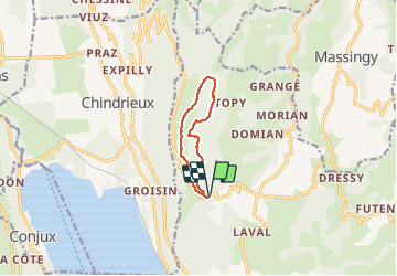
![](/images/other/stat-length.png)
![Excursión Senderismo Entrelacs - SAPENAY: MONTAGNE DE CESSENS - Photo](https://media.geolcdn.com/t/1900/400/cae53790-ce06-4ff8-a857-f0d1206d4970.jpg&format=pjpeg&maxdim=2)
SAPENAY: MONTAGNE DE CESSENS
djeepee74
Usuario
![Longitud](/images/other/stat-length.png)
![Altitud máxima](https://static1.geolcdn.com/siteimages/upload/files/1508320355ic_sort_altitude_max_24dp.png)
![Desnivel positivo](https://static1.geolcdn.com/siteimages/upload/files/1508320355ic_sort_den_pos_24dp.png)
![Km-Effort](/images/other/stat-length.png)
![Altitud mínima](https://static1.geolcdn.com/siteimages/upload/files/1508320355ic_sort_altitude_min_24dp.png)
![Desnivel negativo](https://static1.geolcdn.com/siteimages/upload/files/1508320355ic_sort_den_neg_24dp.png)
![Boucle](https://static1.geolcdn.com/siteimages/upload/files/16400158638029165_repeat_loop_refresh_sync_direction_icon.png)
![Senderismo](https://static1.geolcdn.com/sitytour/trail-icons/101.png)
2h35
Dificultad : Fácil
![Escanee este código QR para abrir la excursión en la aplicación SityTrail](https://capi.geolives.com/qq0zvz2zws4bq2lad0pu/sitytour/trails/2314235/qr.png?size=200)
Aplicación GPS de excursión GRATIS
A propósito
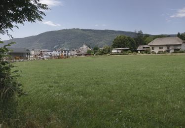
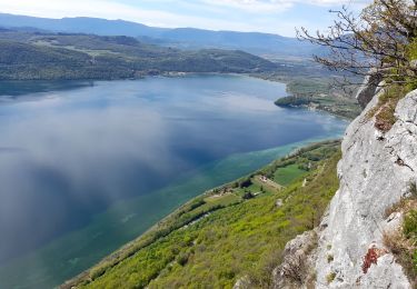
Ruta Senderismo de 7,9 km a descubrir en Auvergne-Rhône-Alpes, Saboya, Entrelacs. Esta ruta ha sido propuesta por djeepee74.
Descripción
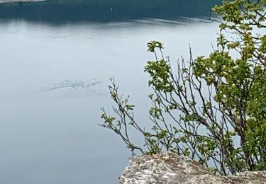
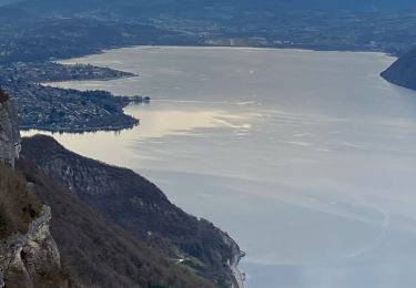
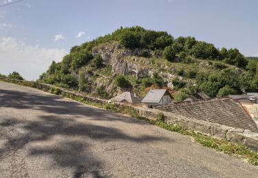
BOUCLE (enregistrement en live)... au départ du "parking de la carrière", juste avant la chapelle de Cessens "Notre Dame de la Salette".
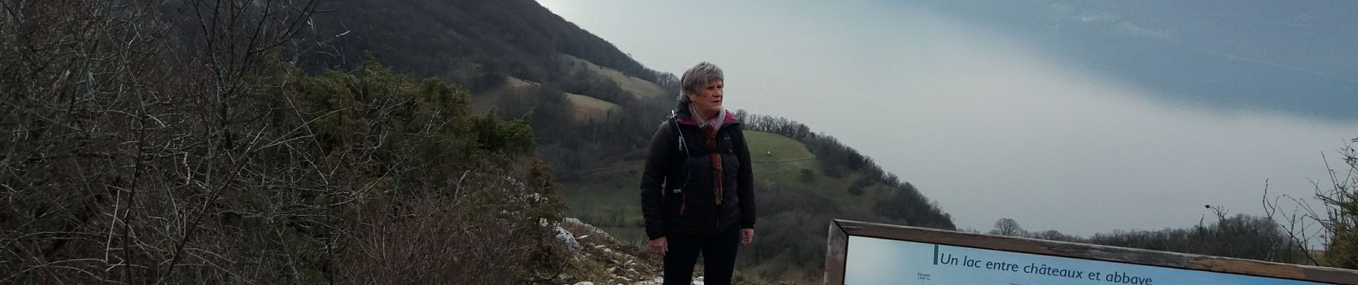
Première table d'orientation: accès par sentier (pente raide) départ entre le "parking de la carrière" et la chapelle de Cessens "Notre Dame de la Salette".
Seconde table d'orientation (au sommet de la "montagne de Cessens"): accès par la falaise (passage aérien... peu exposé et court) départ juste à l'arrivée au "parking de l'hotel Barthelier".
Ce circuit est adaptable à de nombreuses variantes...
Localización
Comentarios
Excursiones cerca
![Excursión Senderismo Chindrieux - Sur les Pas des Huguenots - Chindrieux - Serrières en Chautagne - Photo](https://media.geolcdn.com/t/375/260/ext.jpg?maxdim=2&url=https%3A%2F%2Fservices.sitytrail.com%2FGeolivesWS%2FDownloadMedia.ashx%3FTrailID%3D129664%26Media%3D13193_3.jpg)
![Senderismo Senderismo](https://static1.geolcdn.com/sitytour/trail-icons/101.png)
Senderismo
![](/images/other/stat-length.png)
![](https://static1.geolcdn.com/siteimages/upload/files/16400158638029165_repeat_loop_refresh_sync_direction_icon.png)
![Excursión Senderismo Entrelacs - 30-08-2022 La Chambotte - Croix de Meyrieu - Photo](https://media.geolcdn.com/t/375/260/c8704b3f-8048-446a-89ef-a79ba6fd2504.jpg&format=jpg&maxdim=2)
![Senderismo Senderismo](https://static1.geolcdn.com/sitytour/trail-icons/101.png)
Senderismo
![](/images/other/stat-length.png)
![](https://static1.geolcdn.com/siteimages/upload/files/16400158638029165_repeat_loop_refresh_sync_direction_icon.png)
![Excursión Senderismo Massingy - CLERGEON - Photo](https://media.geolcdn.com/t/375/260/ext.jpg?maxdim=2&url=https%3A%2F%2Fservices.sitytrail.com%2FGeolivesWS%2FDownloadMedia.ashx%3FTrailID%3D474185%26Media%3Dc01eb5a7-bf72-4ffc-98fa-1e923f8f3f43.jpg)
![Senderismo Senderismo](https://static1.geolcdn.com/sitytour/trail-icons/101.png)
Senderismo
![](/images/other/stat-length.png)
![](https://static1.geolcdn.com/siteimages/upload/files/16400158638029165_repeat_loop_refresh_sync_direction_icon.png)
![Excursión Senderismo Entrelacs - SAPENAY / CLERGEON: GRANDE CUVE - Photo](https://media.geolcdn.com/t/375/260/81ea709e-f7b9-477c-93c3-923ab4e12c63.jpg&format=jpg&maxdim=2)
![Senderismo Senderismo](https://static1.geolcdn.com/sitytour/trail-icons/101.png)
Senderismo
![](/images/other/stat-length.png)
![](https://static1.geolcdn.com/siteimages/upload/files/16400158638029165_repeat_loop_refresh_sync_direction_icon.png)
![Excursión Senderismo Entrelacs - Belvédère de la Chambotte - Mont de Corsuet - Photo](https://media.geolcdn.com/t/375/260/320ab627-8a91-46ea-b3a7-34db91702556.jpg&format=jpg&maxdim=2)
![Senderismo Senderismo](https://static1.geolcdn.com/sitytour/trail-icons/101.png)
Senderismo
![](/images/other/stat-length.png)
![](https://static1.geolcdn.com/siteimages/upload/files/16400158638029165_repeat_loop_refresh_sync_direction_icon.png)
![Excursión Senderismo Entrelacs - La chambotte mont laval aix les bains - Photo](https://media.geolcdn.com/t/375/260/83780321-69f1-4ca1-9229-55e6ffa1c410.jpg&format=jpg&maxdim=2)
![Senderismo Senderismo](https://static1.geolcdn.com/sitytour/trail-icons/101.png)
Senderismo
![](/images/other/stat-length.png)
![](https://static1.geolcdn.com/siteimages/upload/files/16400158638029165_repeat_loop_refresh_sync_direction_icon.png)
![Excursión Senderismo Entrelacs - Bellevedere de la Chambotte - Photo](https://media.geolcdn.com/t/375/260/69045582-c557-4058-9efb-585a49f48118.jpg&format=jpg&maxdim=2)
![Senderismo Senderismo](https://static1.geolcdn.com/sitytour/trail-icons/101.png)
Senderismo
![](/images/other/stat-length.png)
![](https://static1.geolcdn.com/siteimages/upload/files/16400158638029165_repeat_loop_refresh_sync_direction_icon.png)
![Excursión Senderismo La Biolle - La Biolle - Photo](https://media.geolcdn.com/t/375/260/fe7a0a14-cbca-4a8d-bceb-b57e7cb64bdc.jpg&format=jpg&maxdim=2)
![Senderismo Senderismo](https://static1.geolcdn.com/sitytour/trail-icons/101.png)
Senderismo
![](/images/other/stat-length.png)
![](https://static1.geolcdn.com/siteimages/upload/files/16400158638029165_repeat_loop_refresh_sync_direction_icon.png)
![Excursión Senderismo Entrelacs - CHAMBOTTE: DECRASSAGE SUR LES CRETES - Photo](https://media.geolcdn.com/t/375/260/ddde69c3-3462-4077-ba6c-e835ee2db56d.jpg&format=jpg&maxdim=2)
![Senderismo Senderismo](https://static1.geolcdn.com/sitytour/trail-icons/101.png)
Senderismo
![](/images/other/stat-length.png)
![](https://static1.geolcdn.com/siteimages/upload/files/16400158638029165_repeat_loop_refresh_sync_direction_icon.png)