![](/images/other/stat-length.png)
![Excursión Otra actividad Gais - Challange_08_S3 - Photo](https://media.geolcdn.com/t/1900/400/ext.pjpeg?maxdim=2&url=https%3A%2F%2Fstatic1.geolcdn.com%2Fsiteimages%2Fupload%2Ffiles%2F1545311037marcheuse_200dpi.jpg)
Challange_08_S3
merlot
Usuario
![Longitud](/images/other/stat-length.png)
Longitud
11,6 km
![Altitud máxima](https://static1.geolcdn.com/siteimages/upload/files/1508320355ic_sort_altitude_max_24dp.png)
Altitud máxima
1232 m
![Desnivel positivo](https://static1.geolcdn.com/siteimages/upload/files/1508320355ic_sort_den_pos_24dp.png)
Desnivel positivo
521 m
![Km-Effort](/images/other/stat-length.png)
Km-Effort
18,2 km
![Altitud mínima](https://static1.geolcdn.com/siteimages/upload/files/1508320355ic_sort_altitude_min_24dp.png)
Altitud mínima
827 m
![Desnivel negativo](https://static1.geolcdn.com/siteimages/upload/files/1508320355ic_sort_den_neg_24dp.png)
Desnivel negativo
441 m
![Boucle](https://static1.geolcdn.com/siteimages/upload/files/16400158638029165_repeat_loop_refresh_sync_direction_icon.png)
Boucle
No
Fecha de creación :
2014-12-11 00:00:00.0
Última modificación :
2014-12-11 00:00:00.0
![Otra actividad](https://static1.geolcdn.com/sitytour/trail-icons/900.png)
--
Dificultad : Desconocido
![Escanee este código QR para abrir la excursión en la aplicación SityTrail](https://capi.geolives.com/qq0zvz2zws4bq2lad0pu/sitytour/trails/23071/qr.png?size=200)
Aplicación GPS de excursión GRATIS
A propósito
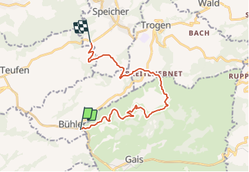
Ruta Otra actividad de 11,6 km a descubrir en Appenzell Rodas Exteriores, Mittelland, Gais. Esta ruta ha sido propuesta por merlot.
Descripción
Herisau,Flawiler Egg, Wolfertswil,Böschenbach,Hoffeld, Ebersol,Necker, Spreitenbach, Reitenberg, Heiterswil, Hemberg, Bächli,Schönau, Urnäsch, Gonten, Appenzell, Haslen,Stein, Hundwil, Herisau
Localización
País:
Switzerland
Región :
Appenzell Rodas Exteriores
Departamento/provincia :
Mittelland
Municipio :
Gais
Localidad:
Unknown
Salida:(Dec)
Salida:(UTM)
532285 ; 5246651 (32T) N.
Comentarios
Excursiones cerca
![Excursión A pie Appenzell - Pfeff ond Lischt - Photo](https://media.geolcdn.com/t/375/260/5b17cc9c-a174-4318-baae-ead2d8248d4b.jpeg&format=jpg&maxdim=2)
![A pie A pie](https://static1.geolcdn.com/sitytour/trail-icons/100.png)
Pfeff ond Lischt
A pie
Fácil
Appenzell,
Appenzell Rodas Interiores,
Desconocido,
Switzerland
![](/images/other/stat-length.png)
3,4 km | 5,4 km-effort
1h 13min
![](https://static1.geolcdn.com/siteimages/upload/files/16400158638029165_repeat_loop_refresh_sync_direction_icon.png)
No
![Excursión A pie Gonten - Flucht - Hundwilerhöhe - Photo](https://media.geolcdn.com/t/375/260/5b17cc9c-a174-4318-baae-ead2d8248d4b.jpeg&format=jpg&maxdim=2)
![A pie A pie](https://static1.geolcdn.com/sitytour/trail-icons/100.png)
Flucht - Hundwilerhöhe
A pie
Fácil
Gonten,
Appenzell Rodas Interiores,
Desconocido,
Switzerland
![](/images/other/stat-length.png)
5,3 km | 11,1 km-effort
2h 31min
![](https://static1.geolcdn.com/siteimages/upload/files/16400158638029165_repeat_loop_refresh_sync_direction_icon.png)
No
![Excursión A pie Speicher - Rund um Speicher - Photo](https://media.geolcdn.com/t/375/260/0dbdec03-b699-49d7-8f78-b24063e471f2.jpeg&format=jpg&maxdim=2)
![A pie A pie](https://static1.geolcdn.com/sitytour/trail-icons/100.png)
Rund um Speicher
A pie
Fácil
Speicher,
Appenzell Rodas Exteriores,
Mittelland,
Switzerland
![](/images/other/stat-length.png)
4,4 km | 5,7 km-effort
1h 17min
![](https://static1.geolcdn.com/siteimages/upload/files/16400158638029165_repeat_loop_refresh_sync_direction_icon.png)
No
![Excursión A pie Rüte - Eggerstanden-Steinegg - Photo](https://media.geolcdn.com/t/375/260/dev_2307862b-39bc-461b-8841-871c81cad67b.jpeg&format=jpg&maxdim=2)
![A pie A pie](https://static1.geolcdn.com/sitytour/trail-icons/100.png)
Eggerstanden-Steinegg
A pie
Fácil
Rüte,
Appenzell Rodas Interiores,
Desconocido,
Switzerland
![](/images/other/stat-length.png)
3,6 km | 4,2 km-effort
56min
![](https://static1.geolcdn.com/siteimages/upload/files/16400158638029165_repeat_loop_refresh_sync_direction_icon.png)
No
![Excursión Bici de montaña Appenzell - Fälensee - Photo](https://media.geolcdn.com/t/375/260/ext.jpg?maxdim=2&url=https%3A%2F%2Fstatic1.geolcdn.com%2Fsiteimages%2Fupload%2Ffiles%2F1524743154velo.jpg)
![Bici de montaña Bici de montaña](https://static1.geolcdn.com/sitytour/trail-icons/202.png)
Fälensee
Bici de montaña
Muy fácil
Appenzell,
Appenzell Rodas Interiores,
Desconocido,
Switzerland
![](/images/other/stat-length.png)
37 km | 54 km-effort
14h 21min
![](https://static1.geolcdn.com/siteimages/upload/files/16400158638029165_repeat_loop_refresh_sync_direction_icon.png)
Sí
![Excursión Bici de montaña Appenzell - Bike32873 - Photo](https://media.geolcdn.com/t/375/260/ext.jpg?maxdim=2&url=https%3A%2F%2Fstatic1.geolcdn.com%2Fsiteimages%2Fupload%2Ffiles%2F1524743154velo.jpg)
![Bici de montaña Bici de montaña](https://static1.geolcdn.com/sitytour/trail-icons/202.png)
Bike32873
Bici de montaña
Muy fácil
Appenzell,
Appenzell Rodas Interiores,
Desconocido,
Switzerland
![](/images/other/stat-length.png)
19,9 km | 29 km-effort
Desconocido
![](https://static1.geolcdn.com/siteimages/upload/files/16400158638029165_repeat_loop_refresh_sync_direction_icon.png)
Sí
![Excursión Bici de montaña Appenzell - Bike32869 - Photo](https://media.geolcdn.com/t/375/260/ext.jpg?maxdim=2&url=https%3A%2F%2Fstatic1.geolcdn.com%2Fsiteimages%2Fupload%2Ffiles%2F1524743154velo.jpg)
![Bici de montaña Bici de montaña](https://static1.geolcdn.com/sitytour/trail-icons/202.png)
Bike32869
Bici de montaña
Muy fácil
Appenzell,
Appenzell Rodas Interiores,
Desconocido,
Switzerland
![](/images/other/stat-length.png)
35 km | 51 km-effort
15h 23min
![](https://static1.geolcdn.com/siteimages/upload/files/16400158638029165_repeat_loop_refresh_sync_direction_icon.png)
Sí
![Excursión Senderismo Gais - Alpenpanorama_2_2 - Photo](https://media.geolcdn.com/t/375/260/ext.jpg?maxdim=2&url=https%3A%2F%2Fstatic1.geolcdn.com%2Fsiteimages%2Fupload%2Ffiles%2F1553511878bg_sport_marche.png)
![Senderismo Senderismo](https://static1.geolcdn.com/sitytour/trail-icons/101.png)
Alpenpanorama_2_2
Senderismo
Muy fácil
Gais,
Appenzell Rodas Exteriores,
Mittelland,
Switzerland
![](/images/other/stat-length.png)
14,4 km | 19,4 km-effort
5h 0min
![](https://static1.geolcdn.com/siteimages/upload/files/16400158638029165_repeat_loop_refresh_sync_direction_icon.png)
No
![Excursión Otra actividad Trogen - Heiden: Trogen - Rehtobel - Photo](https://media.geolcdn.com/t/375/260/ext.jpg?maxdim=2&url=https%3A%2F%2Fstatic1.geolcdn.com%2Fsiteimages%2Fupload%2Ffiles%2F1545311037marcheuse_200dpi.jpg)
![Otra actividad Otra actividad](https://static1.geolcdn.com/sitytour/trail-icons/900.png)
Heiden: Trogen - Rehtobel
Otra actividad
Muy fácil
Trogen,
Appenzell Rodas Exteriores,
Mittelland,
Switzerland
![](/images/other/stat-length.png)
5 km | 8,1 km-effort
Desconocido
![](https://static1.geolcdn.com/siteimages/upload/files/16400158638029165_repeat_loop_refresh_sync_direction_icon.png)
No