![](/images/other/stat-length.png)
![Excursión Senderismo Villers-la-Ville - Autour du Golf de Rigenée - Photo](https://media.geolcdn.com/t/1900/400/c4b6f24c-b626-4734-ae47-36c322c8f20a.jpg&format=pjpeg&maxdim=2)
Autour du Golf de Rigenée
Lau Maes
Usuario
![Longitud](/images/other/stat-length.png)
Longitud
5,5 km
![Altitud máxima](https://static1.geolcdn.com/siteimages/upload/files/1508320355ic_sort_altitude_max_24dp.png)
Altitud máxima
154 m
![Desnivel positivo](https://static1.geolcdn.com/siteimages/upload/files/1508320355ic_sort_den_pos_24dp.png)
Desnivel positivo
62 m
![Km-Effort](/images/other/stat-length.png)
Km-Effort
6,3 km
![Altitud mínima](https://static1.geolcdn.com/siteimages/upload/files/1508320355ic_sort_altitude_min_24dp.png)
Altitud mínima
125 m
![Desnivel negativo](https://static1.geolcdn.com/siteimages/upload/files/1508320355ic_sort_den_neg_24dp.png)
Desnivel negativo
62 m
![Boucle](https://static1.geolcdn.com/siteimages/upload/files/16400158638029165_repeat_loop_refresh_sync_direction_icon.png)
Boucle
Sí
Fecha de creación :
2020-01-16 09:57:20.0
Última modificación :
2020-01-16 11:27:25.234
![Senderismo](https://static1.geolcdn.com/sitytour/trail-icons/101.png)
1h28
Dificultad : Medio
![Escanee este código QR para abrir la excursión en la aplicación SityTrail](https://capi.geolives.com/qq0zvz2zws4bq2lad0pu/sitytour/trails/2306763/qr.png?size=200)
Aplicación GPS de excursión GRATIS
A propósito
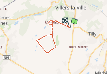
Ruta Senderismo de 5,5 km a descubrir en Valonia, Brabante Valón, Villers-la-Ville. Esta ruta ha sido propuesta por Lau Maes.
Descripción
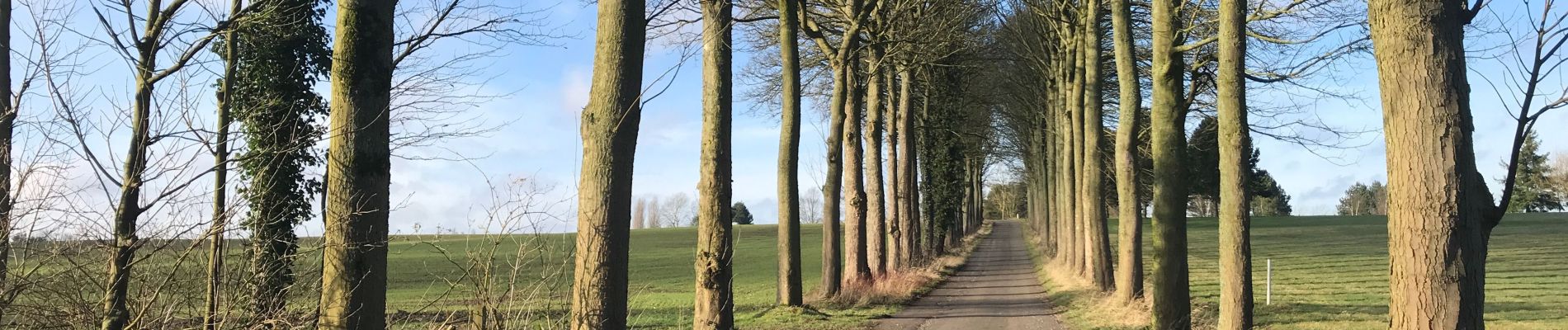
Routes de campagne (peu fréquentées) et sentiers praticables (mais parfois un peu boueux selon la saison).
Localización
País:
Belgium
Región :
Valonia
Departamento/provincia :
Brabante Valón
Municipio :
Villers-la-Ville
Localidad:
Tilly
Salida:(Dec)
Salida:(UTM)
608635 ; 5602585 (31U) N.
Comentarios
Excursiones cerca
![Excursión Senderismo Villers-la-Ville - RB-Bw-10-raccourci 2 - À travers campagnes et forêts, autour des ruines d’une prestigieuse abbaye - Photo](https://media.geolcdn.com/t/375/260/ext.jpg?maxdim=2&url=https%3A%2F%2Fservices.sitytrail.com%2FGeolivesWS%2FDownloadMedia.ashx%3FTrailID%3D220359%26Media%3Db52f8a40-bd4e-4201-848f-58c9caafd869.jpg)
![Senderismo Senderismo](https://static1.geolcdn.com/sitytour/trail-icons/101.png)
RB-Bw-10-raccourci 2 - À travers campagnes et forêts, autour des ruines d’une...
Senderismo
Difícil
(26)
Villers-la-Ville,
Valonia,
Brabante Valón,
Belgium
![](/images/other/stat-length.png)
13,3 km | 16,4 km-effort
3h 44min
![](https://static1.geolcdn.com/siteimages/upload/files/16400158638029165_repeat_loop_refresh_sync_direction_icon.png)
Sí
![Excursión Senderismo Villers-la-Ville - RB-Bw-10 - Villers-la-Ville - 2025-02-08 - Photo](https://media.geolcdn.com/t/375/260/ext.jpg?maxdim=2&url=https%3A%2F%2Fservices.sitytrail.com%2FGeolivesWS%2FDownloadMedia.ashx%3FTrailID%3D220358%26Media%3D903cc0f2-4910-43b5-bcea-92ca954ab4b4.jpg)
![Senderismo Senderismo](https://static1.geolcdn.com/sitytour/trail-icons/101.png)
RB-Bw-10 - Villers-la-Ville - 2025-02-08
Senderismo
Muy difícil
(13)
Villers-la-Ville,
Valonia,
Brabante Valón,
Belgium
![](/images/other/stat-length.png)
24 km | 30 km-effort
6h 43min
![](https://static1.geolcdn.com/siteimages/upload/files/16400158638029165_repeat_loop_refresh_sync_direction_icon.png)
Sí
![Excursión Senderismo Villers-la-Ville - RB-Bw-10 - Villers-la-Ville - Via allongement - 2025-02-08 - Photo](https://media.geolcdn.com/t/375/260/ext.jpg?maxdim=2&url=https%3A%2F%2Fservices.sitytrail.com%2FGeolivesWS%2FDownloadMedia.ashx%3FTrailID%3D179585%26Media%3D903cc0f2-4910-43b5-bcea-92ca954ab4b4.jpg)
![Senderismo Senderismo](https://static1.geolcdn.com/sitytour/trail-icons/101.png)
RB-Bw-10 - Villers-la-Ville - Via allongement - 2025-02-08
Senderismo
Muy difícil
(6)
Villers-la-Ville,
Valonia,
Brabante Valón,
Belgium
![](/images/other/stat-length.png)
26 km | 32 km-effort
7h 15min
![](https://static1.geolcdn.com/siteimages/upload/files/16400158638029165_repeat_loop_refresh_sync_direction_icon.png)
Sí
![Excursión Senderismo Genappe - Genappe - Circuit Natura 2000, des sites qui valent le détour ! - Bw03 - Photo](https://media.geolcdn.com/t/375/260/ext.jpg?maxdim=2&url=https%3A%2F%2Fservices.sitytrail.com%2FGeolivesWS%2FDownloadMedia.ashx%3FTrailID%3D356410%26Media%3D9ffde3d0-226c-45a8-b2a5-1fc6dfbe0f90.jpg)
![Senderismo Senderismo](https://static1.geolcdn.com/sitytour/trail-icons/101.png)
Genappe - Circuit Natura 2000, des sites qui valent le détour ! - Bw03
Senderismo
Medio
(6)
Genappe,
Valonia,
Brabante Valón,
Belgium
![](/images/other/stat-length.png)
7,9 km | 9,7 km-effort
2h 6min
![](https://static1.geolcdn.com/siteimages/upload/files/16400158638029165_repeat_loop_refresh_sync_direction_icon.png)
Sí
![Senderismo Senderismo](https://static1.geolcdn.com/sitytour/trail-icons/101.png)
Bérines
Senderismo
Fácil
(1)
Villers-la-Ville,
Valonia,
Brabante Valón,
Belgium
![](/images/other/stat-length.png)
6,4 km | 7,5 km-effort
1h 41min
![](https://static1.geolcdn.com/siteimages/upload/files/16400158638029165_repeat_loop_refresh_sync_direction_icon.png)
Sí
![Senderismo Senderismo](https://static1.geolcdn.com/sitytour/trail-icons/101.png)
BE-Villers-la-Ville - Le Bois Pigeolet et le Châtelet - VLV 7
Senderismo
Fácil
(1)
Villers-la-Ville,
Valonia,
Brabante Valón,
Belgium
![](/images/other/stat-length.png)
6,6 km | 7,8 km-effort
1h 42min
![](https://static1.geolcdn.com/siteimages/upload/files/16400158638029165_repeat_loop_refresh_sync_direction_icon.png)
Sí
![Excursión Senderismo Villers-la-Ville - Balade forestière à Villers la Ville - Photo](https://media.geolcdn.com/t/375/260/ext.jpg?maxdim=2&url=https%3A%2F%2Fservices.sitytrail.com%2FGeolivesWS%2FDownloadMedia.ashx%3FTrailID%3D120927%26Media%3D124af64a-52e1-4866-a6e4-05b50b4835ef.JPG)
![Senderismo Senderismo](https://static1.geolcdn.com/sitytour/trail-icons/101.png)
Balade forestière à Villers la Ville
Senderismo
Fácil
(5)
Villers-la-Ville,
Valonia,
Brabante Valón,
Belgium
![](/images/other/stat-length.png)
11,5 km | 14,1 km-effort
3h 0min
![](https://static1.geolcdn.com/siteimages/upload/files/16400158638029165_repeat_loop_refresh_sync_direction_icon.png)
Sí
![Excursión Senderismo Court-Saint-Étienne - #240304 - La Roche, bois Ste Catherine et du Sartage - Photo](https://media.geolcdn.com/t/375/260/d185017a-b96f-406a-b9d2-c4084024f2c7.jpg&format=jpg&maxdim=2)
![Senderismo Senderismo](https://static1.geolcdn.com/sitytour/trail-icons/101.png)
#240304 - La Roche, bois Ste Catherine et du Sartage
Senderismo
Medio
(1)
Court-Saint-Étienne,
Valonia,
Brabante Valón,
Belgium
![](/images/other/stat-length.png)
5,8 km | 7,6 km-effort
1h 42min
![](https://static1.geolcdn.com/siteimages/upload/files/16400158638029165_repeat_loop_refresh_sync_direction_icon.png)
Sí
![Senderismo Senderismo](https://static1.geolcdn.com/sitytour/trail-icons/101.png)
#230728 - Gentinnes Kongolo
Senderismo
Fácil
(1)
Chastre,
Valonia,
Brabante Valón,
Belgium
![](/images/other/stat-length.png)
5 km | 5,6 km-effort
1h 16min
![](https://static1.geolcdn.com/siteimages/upload/files/16400158638029165_repeat_loop_refresh_sync_direction_icon.png)
Sí