![](/images/other/stat-length.png)
![Excursión Esquí de fondo Aime-la-Plagne - le Crêt du Rey face Est - Photo](https://media.geolcdn.com/t/1900/400/85030d7c-824d-4fcc-8e4c-058138221f73.jpg&format=pjpeg&maxdim=2)
le Crêt du Rey face Est
nadd73
Usuario GUIDE
![Longitud](/images/other/stat-length.png)
![Altitud máxima](https://static1.geolcdn.com/siteimages/upload/files/1508320355ic_sort_altitude_max_24dp.png)
![Desnivel positivo](https://static1.geolcdn.com/siteimages/upload/files/1508320355ic_sort_den_pos_24dp.png)
![Km-Effort](/images/other/stat-length.png)
![Altitud mínima](https://static1.geolcdn.com/siteimages/upload/files/1508320355ic_sort_altitude_min_24dp.png)
![Desnivel negativo](https://static1.geolcdn.com/siteimages/upload/files/1508320355ic_sort_den_neg_24dp.png)
![Boucle](https://static1.geolcdn.com/siteimages/upload/files/16400158638029165_repeat_loop_refresh_sync_direction_icon.png)
![Esquí de fondo](https://static1.geolcdn.com/sitytour/trail-icons/503.png)
8h21
Dificultad : Difícil
![Escanee este código QR para abrir la excursión en la aplicación SityTrail](https://capi.geolives.com/qq0zvz2zws4bq2lad0pu/sitytour/trails/2303823/qr.png?size=200)
Aplicación GPS de excursión GRATIS
A propósito
Ruta Esquí de fondo de 18,7 km a descubrir en Auvergne-Rhône-Alpes, Saboya, Aime-la-Plagne. Esta ruta ha sido propuesta por nadd73.
Descripción
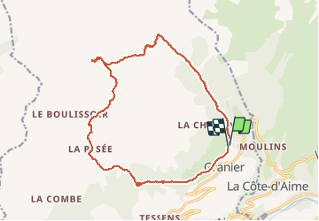
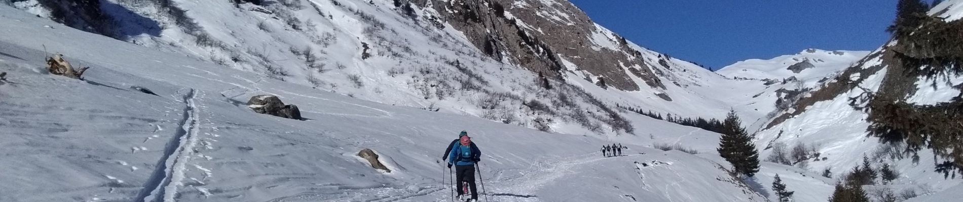
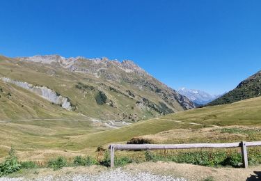
De Granier après le télésiège nous avons pris le GR du Beaufortain jusqu'à Laval et Pré jeune. ensuite suivre le ruisseau. la montée dans le couloir Est est exposé mieux prendre l'arête NE qui est souvent tracée. Crampons nécessaires suivant la neige.
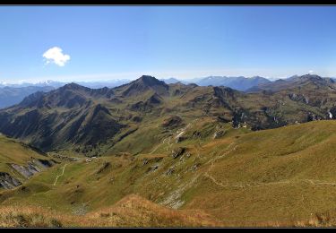
Descente dans le couloir repeauter pour monter au col de corne noire.
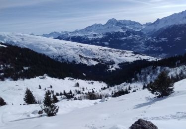
Descente sur Fruit et la Pesée.
Au Chapieu il est préférable de prendre le chemin qui mène au milieu du télésiège et il restera plus qu'à descendre à la voiture.
Localización
Comentarios
Excursiones cerca
![Excursión Senderismo La Plagne-Tarentaise - Les Fours- belle rando facile - Photo](https://media.geolcdn.com/t/375/260/ce194bd9-f6a3-46bc-be1d-c29d53223d34.jpg&format=jpg&maxdim=2)
![Senderismo Senderismo](https://static1.geolcdn.com/sitytour/trail-icons/101.png)
Senderismo
![](/images/other/stat-length.png)
![](https://static1.geolcdn.com/siteimages/upload/files/16400158638029165_repeat_loop_refresh_sync_direction_icon.png)
![Excursión Senderismo La Plagne-Tarentaise - Les Fours - Photo](https://media.geolcdn.com/t/375/260/ext.jpg?maxdim=2&url=https%3A%2F%2Fservices.sitytrail.com%2FGeolivesWS%2FDownloadMedia.ashx%3FTrailID%3D962720%26Media%3Dfix__20180506164939.jpg)
![Senderismo Senderismo](https://static1.geolcdn.com/sitytour/trail-icons/101.png)
Senderismo
![](/images/other/stat-length.png)
![](https://static1.geolcdn.com/siteimages/upload/files/16400158638029165_repeat_loop_refresh_sync_direction_icon.png)
![Excursión Senderismo Aime-la-Plagne - 2024-09-08 Marche Tour Beaufortain Refuge Coire vers Refuge Presset - Photo](https://media.geolcdn.com/t/375/260/b0c8e42e-e06a-4d0e-aaaf-41f5a8616494.jpg&format=jpg&maxdim=2)
![Senderismo Senderismo](https://static1.geolcdn.com/sitytour/trail-icons/101.png)
Senderismo
![](/images/other/stat-length.png)
![](https://static1.geolcdn.com/siteimages/upload/files/16400158638029165_repeat_loop_refresh_sync_direction_icon.png)
![Excursión Senderismo La Plagne-Tarentaise - 73 Tarentaise Col du Mont Rosset Refuge de la Balme-Col et Charbonnière Lac de la Portette - Photo](https://media.geolcdn.com/t/375/260/ext.jpg?maxdim=2&url=https%3A%2F%2Fstatic1.geolcdn.com%2Fsiteimages%2Fupload%2Ffiles%2F1553511878bg_sport_marche.png)
![Senderismo Senderismo](https://static1.geolcdn.com/sitytour/trail-icons/101.png)
Senderismo
![](/images/other/stat-length.png)
![](https://static1.geolcdn.com/siteimages/upload/files/16400158638029165_repeat_loop_refresh_sync_direction_icon.png)
![Excursión Esquí de fondo La Plagne-Tarentaise - La Chaille. col à l'ouest du Rocher st Laurent - Photo](https://media.geolcdn.com/t/375/260/a890abcf-139f-4fa9-a31e-dd584261d663.jpg&format=jpg&maxdim=2)
![Esquí de fondo Esquí de fondo](https://static1.geolcdn.com/sitytour/trail-icons/503.png)
Esquí de fondo
![](/images/other/stat-length.png)
![](https://static1.geolcdn.com/siteimages/upload/files/16400158638029165_repeat_loop_refresh_sync_direction_icon.png)
![Excursión Senderismo Aime-la-Plagne - Balcons de Granier - Photo](https://media.geolcdn.com/t/375/260/ext.jpg?maxdim=2&url=https%3A%2F%2Fstatic1.geolcdn.com%2Fsiteimages%2Fupload%2Ffiles%2F1553511878bg_sport_marche.png)
![Senderismo Senderismo](https://static1.geolcdn.com/sitytour/trail-icons/101.png)
Senderismo
![](/images/other/stat-length.png)
![](https://static1.geolcdn.com/siteimages/upload/files/16400158638029165_repeat_loop_refresh_sync_direction_icon.png)
![Excursión Raquetas de nieve Aime-la-Plagne - combe benite - Photo](https://media.geolcdn.com/t/375/260/ext.jpg?maxdim=2&url=https%3A%2F%2Fstatic1.geolcdn.com%2Fsiteimages%2Fupload%2Ffiles%2F1524743153raquette.jpg)
![Raquetas de nieve Raquetas de nieve](https://static1.geolcdn.com/sitytour/trail-icons/504.png)
Raquetas de nieve
![](/images/other/stat-length.png)
![](https://static1.geolcdn.com/siteimages/upload/files/16400158638029165_repeat_loop_refresh_sync_direction_icon.png)
![Excursión Senderismo Aime-la-Plagne - Lac de Presset par la Piera Menta depuis le Cornet d'Arêches - Photo](https://media.geolcdn.com/t/375/260/fa489cc8-f4d2-4b43-8b50-128576704080.jpg&format=jpg&maxdim=2)
![Senderismo Senderismo](https://static1.geolcdn.com/sitytour/trail-icons/101.png)
Senderismo
![](/images/other/stat-length.png)
![](https://static1.geolcdn.com/siteimages/upload/files/16400158638029165_repeat_loop_refresh_sync_direction_icon.png)
![Excursión Senderismo Aime-la-Plagne - Mont Coin - Photo](https://media.geolcdn.com/t/375/260/4f563390-2587-42f5-8996-ce783b07d0a6.jpg&format=jpg&maxdim=2)
![Senderismo Senderismo](https://static1.geolcdn.com/sitytour/trail-icons/101.png)
Senderismo
![](/images/other/stat-length.png)
![](https://static1.geolcdn.com/siteimages/upload/files/16400158638029165_repeat_loop_refresh_sync_direction_icon.png)