![](/images/other/stat-length.png)
![Excursión Senderismo Die - Le Glandasse (Abbaye-Fauchard-Comptoir-à-Moutons) - Photo](https://media.geolcdn.com/t/1900/400/cf25a4c2-c414-4c17-a9a5-20c55cfe9d9f.jpg&format=pjpeg&maxdim=2)
Le Glandasse (Abbaye-Fauchard-Comptoir-à-Moutons)
Philindy26
Usuario
![Longitud](/images/other/stat-length.png)
![Altitud máxima](https://static1.geolcdn.com/siteimages/upload/files/1508320355ic_sort_altitude_max_24dp.png)
![Desnivel positivo](https://static1.geolcdn.com/siteimages/upload/files/1508320355ic_sort_den_pos_24dp.png)
![Km-Effort](/images/other/stat-length.png)
![Altitud mínima](https://static1.geolcdn.com/siteimages/upload/files/1508320355ic_sort_altitude_min_24dp.png)
![Desnivel negativo](https://static1.geolcdn.com/siteimages/upload/files/1508320355ic_sort_den_neg_24dp.png)
![Boucle](https://static1.geolcdn.com/siteimages/upload/files/16400158638029165_repeat_loop_refresh_sync_direction_icon.png)
![Senderismo](https://static1.geolcdn.com/sitytour/trail-icons/101.png)
4h30
Dificultad : Difícil
![Escanee este código QR para abrir la excursión en la aplicación SityTrail](https://capi.geolives.com/qq0zvz2zws4bq2lad0pu/sitytour/trails/2291909/qr.png?size=200)
Aplicación GPS de excursión GRATIS
A propósito
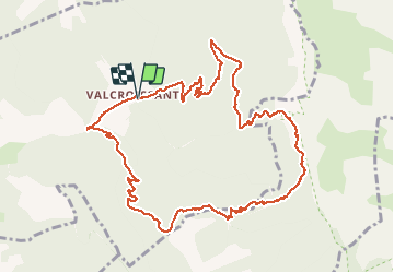
Ruta Senderismo de 12,3 km a descubrir en Auvergne-Rhône-Alpes, Drôme, Die. Esta ruta ha sido propuesta por Philindy26.
Descripción
Départ du parking de l'Abbaye de Valcroissant à Die...
Géolocalisation (Google Maps) : https://goo.gl/maps/t38pzYLnE1uLgqq67 .
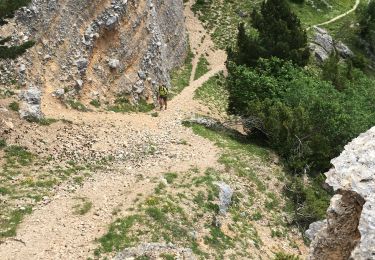
Prendre la direction du Pas de la Coche (594 m), puis le Col de l'Abbaye (848 m), le Col Fauchard (909 m), le Col de Cologne (1207 m) et le Comptoir à Moutons (1520 m).
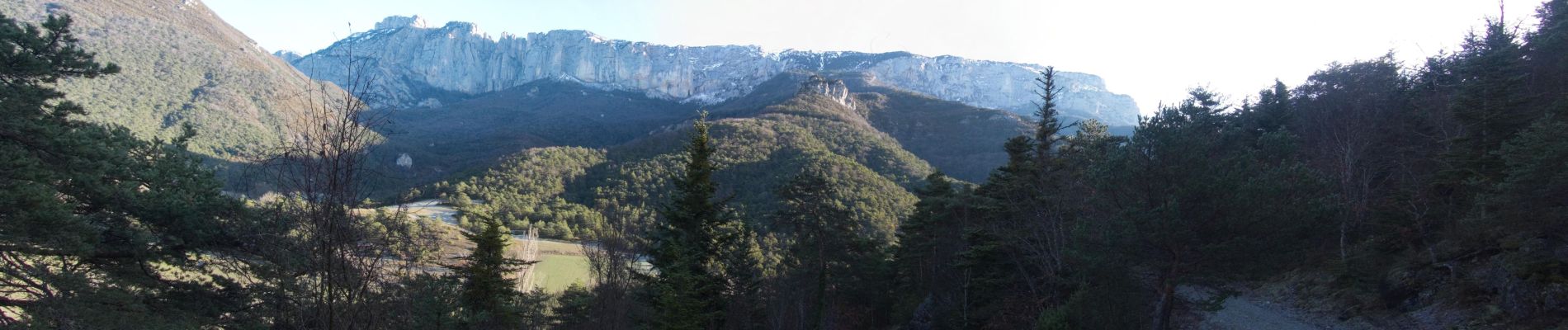
Normalement, vous pourrez y observer des bouquetins...
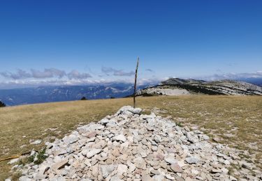
De là vous pourrez monter au Dôme ou Pié Ferré, point culminant du Glandasse avec 2041 mètres d'altitude (les 4h30 n'en tiens pas compte...).
Sinon, descente par la Fontaine de Juillet (1058 m) et les Quatres Chemins (1021 m).
Localización
Comentarios
Excursiones cerca
![Excursión sport Die - Val croissant comptoir des moutons - Photo](https://media.geolcdn.com/t/375/260/3b919326-2e50-400f-bc15-c6be506dcde0.jpg&format=jpg&maxdim=2)
sport
![](/images/other/stat-length.png)
![](https://static1.geolcdn.com/siteimages/upload/files/16400158638029165_repeat_loop_refresh_sync_direction_icon.png)
![Excursión Senderismo Die - Col de Bergu - Photo](https://media.geolcdn.com/t/375/260/cd646939-5ef5-44d1-b09a-be899a9a43a7.jpg&format=jpg&maxdim=2)
![Senderismo Senderismo](https://static1.geolcdn.com/sitytour/trail-icons/101.png)
Senderismo
![](/images/other/stat-length.png)
![](https://static1.geolcdn.com/siteimages/upload/files/16400158638029165_repeat_loop_refresh_sync_direction_icon.png)
![Excursión Senderismo Die - Abbaye de Valcroissant - Photo](https://media.geolcdn.com/t/375/260/a9356d67-59c3-4251-97a5-c480f0ff70f4.jpg&format=jpg&maxdim=2)
![Senderismo Senderismo](https://static1.geolcdn.com/sitytour/trail-icons/101.png)
Senderismo
![](/images/other/stat-length.png)
![](https://static1.geolcdn.com/siteimages/upload/files/16400158638029165_repeat_loop_refresh_sync_direction_icon.png)
![Excursión sport Die - Croix de Justin , Ausson - Photo](https://media.geolcdn.com/t/375/260/c8090ee5-5a94-4ee1-b2d3-2c37d8bd6d5e.jpg&format=jpg&maxdim=2)
sport
![](/images/other/stat-length.png)
![](https://static1.geolcdn.com/siteimages/upload/files/16400158638029165_repeat_loop_refresh_sync_direction_icon.png)
![Excursión Senderismo Châtillon-en-Diois - Cabane de Chatillon - Photo](https://media.geolcdn.com/t/375/260/ea94f18f-fca1-490f-aab1-2356b5263731.jpg&format=jpg&maxdim=2)
![Senderismo Senderismo](https://static1.geolcdn.com/sitytour/trail-icons/101.png)
Senderismo
![](/images/other/stat-length.png)
![](https://static1.geolcdn.com/siteimages/upload/files/16400158638029165_repeat_loop_refresh_sync_direction_icon.png)
![Excursión Senderismo Die - Tour Abbaye Val Croissant - Photo](https://media.geolcdn.com/t/375/260/a03f9356-ba67-4c89-83cb-2b5b84968cb8.jpg&format=jpg&maxdim=2)
![Senderismo Senderismo](https://static1.geolcdn.com/sitytour/trail-icons/101.png)
Senderismo
![](/images/other/stat-length.png)
![](https://static1.geolcdn.com/siteimages/upload/files/16400158638029165_repeat_loop_refresh_sync_direction_icon.png)
![Excursión Senderismo Die - Abbaye Val croissant - Chatillon en diois - Photo](https://media.geolcdn.com/t/375/260/decff8a0-8389-400f-be19-ef575d278e3e.jpg&format=jpg&maxdim=2)
![Senderismo Senderismo](https://static1.geolcdn.com/sitytour/trail-icons/101.png)
Senderismo
![](/images/other/stat-length.png)
![](https://static1.geolcdn.com/siteimages/upload/files/16400158638029165_repeat_loop_refresh_sync_direction_icon.png)
![Excursión Senderismo Die - Le Dôme ou Pié Ferré de l'Abbaye Valcroissant - Photo](https://media.geolcdn.com/t/375/260/3d8ae844-73e5-46a2-af4b-edc98cdca1a6.jpg&format=jpg&maxdim=2)
![Senderismo Senderismo](https://static1.geolcdn.com/sitytour/trail-icons/101.png)
Senderismo
![](/images/other/stat-length.png)
![](https://static1.geolcdn.com/siteimages/upload/files/16400158638029165_repeat_loop_refresh_sync_direction_icon.png)
![Excursión Senderismo Die - Le Pestel - Photo](https://media.geolcdn.com/t/375/260/7b115de7-b12b-4372-8599-921e486c09f6.jpg&format=jpg&maxdim=2)
![Senderismo Senderismo](https://static1.geolcdn.com/sitytour/trail-icons/101.png)
Senderismo
![](/images/other/stat-length.png)
![](https://static1.geolcdn.com/siteimages/upload/files/16400158638029165_repeat_loop_refresh_sync_direction_icon.png)