![](/images/other/stat-length.png)
![Excursión Raquetas de nieve Belvédère - Cime de Montjoia - Photo](https://media.geolcdn.com/t/1900/400/ext.pjpeg?maxdim=2&url=https%3A%2F%2Fstatic1.geolcdn.com%2Fsiteimages%2Fupload%2Ffiles%2F1524743153raquette.jpg)
Cime de Montjoia
bozo1970
Usuario
![Longitud](/images/other/stat-length.png)
Longitud
8,3 km
![Altitud máxima](https://static1.geolcdn.com/siteimages/upload/files/1508320355ic_sort_altitude_max_24dp.png)
Altitud máxima
2348 m
![Desnivel positivo](https://static1.geolcdn.com/siteimages/upload/files/1508320355ic_sort_den_pos_24dp.png)
Desnivel positivo
732 m
![Km-Effort](/images/other/stat-length.png)
Km-Effort
18 km
![Altitud mínima](https://static1.geolcdn.com/siteimages/upload/files/1508320355ic_sort_altitude_min_24dp.png)
Altitud mínima
1615 m
![Desnivel negativo](https://static1.geolcdn.com/siteimages/upload/files/1508320355ic_sort_den_neg_24dp.png)
Desnivel negativo
722 m
![Boucle](https://static1.geolcdn.com/siteimages/upload/files/16400158638029165_repeat_loop_refresh_sync_direction_icon.png)
Boucle
Sí
Fecha de creación :
2019-12-27 08:36:16.0
Última modificación :
2019-12-27 14:39:30.0
![Raquetas de nieve](https://static1.geolcdn.com/sitytour/trail-icons/504.png)
3h35
Dificultad : Difícil
![Escanee este código QR para abrir la excursión en la aplicación SityTrail](https://capi.geolives.com/qq0zvz2zws4bq2lad0pu/sitytour/trails/2291287/qr.png?size=200)
Aplicación GPS de excursión GRATIS
A propósito
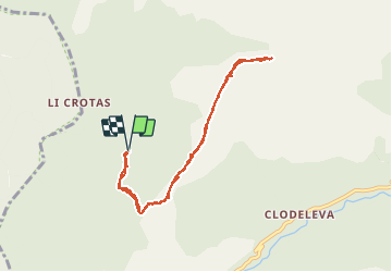
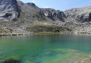
Ruta Raquetas de nieve de 8,3 km a descubrir en Provenza-Alpes-Costa Azul, Alpes Marítimos, Belvédère. Esta ruta ha sido propuesta por bozo1970.
Descripción
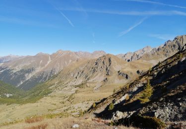
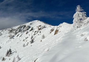
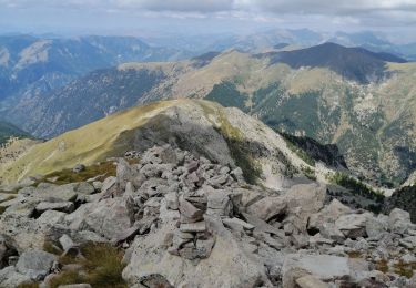
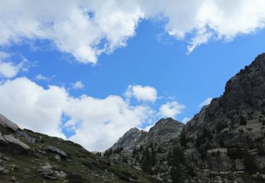
Par la crête de Bermonnet en aller retour.
D 733m
8,3 Km
3h35’
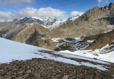
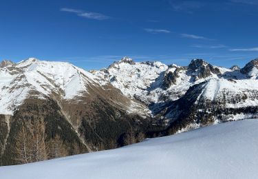
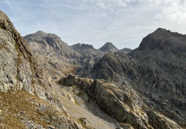
La crête sommitale est exceptionnelle sous la neige !
Localización
País:
France
Región :
Provenza-Alpes-Costa Azul
Departamento/provincia :
Alpes Marítimos
Municipio :
Belvédère
Localidad:
Unknown
Salida:(Dec)
Salida:(UTM)
366228 ; 4878360 (32T) N.
Comentarios
Excursiones cerca
![Excursión Senderismo Belvédère - Via Alpina - D60: Belvédère > Col de Turini - Photo](https://media.geolcdn.com/t/375/260/ext.jpg?maxdim=2&url=https%3A%2F%2Fservices.sitytrail.com%2FGeolivesWS%2FDownloadMedia.ashx%3FTrailID%3D109715%26Media%3D4424_1.jpg)
![Senderismo Senderismo](https://static1.geolcdn.com/sitytour/trail-icons/101.png)
Via Alpina - D60: Belvédère > Col de Turini
Senderismo
Muy difícil
(1)
Belvédère,
Provenza-Alpes-Costa Azul,
Alpes Marítimos,
France
![](/images/other/stat-length.png)
16,6 km | 33 km-effort
5h 30min
![](https://static1.geolcdn.com/siteimages/upload/files/16400158638029165_repeat_loop_refresh_sync_direction_icon.png)
No
![Excursión Senderismo Belvédère - Cime de Paranova - Photo](https://media.geolcdn.com/t/375/260/cc4e7066-5464-4b8a-b1d4-23e04de7987f.jpg&format=jpg&maxdim=2)
![Senderismo Senderismo](https://static1.geolcdn.com/sitytour/trail-icons/101.png)
Cime de Paranova
Senderismo
Medio
Belvédère,
Provenza-Alpes-Costa Azul,
Alpes Marítimos,
France
![](/images/other/stat-length.png)
9,6 km | 23 km-effort
4h 4min
![](https://static1.geolcdn.com/siteimages/upload/files/16400158638029165_repeat_loop_refresh_sync_direction_icon.png)
Sí
![Excursión Raquetas de nieve Belvédère - Mont Lapassé - Photo](https://media.geolcdn.com/t/375/260/c2e3a941-8e45-49f3-8436-b2bb41d1677c.jpg&format=jpg&maxdim=2)
![Raquetas de nieve Raquetas de nieve](https://static1.geolcdn.com/sitytour/trail-icons/504.png)
Mont Lapassé
Raquetas de nieve
Medio
Belvédère,
Provenza-Alpes-Costa Azul,
Alpes Marítimos,
France
![](/images/other/stat-length.png)
8,8 km | 16,8 km-effort
2h 53min
![](https://static1.geolcdn.com/siteimages/upload/files/16400158638029165_repeat_loop_refresh_sync_direction_icon.png)
Sí
![Excursión Senderismo Belvédère - Mont Colomb - Photo](https://media.geolcdn.com/t/375/260/221e8a9d-00f9-4399-81ae-78f4e77f3f4a.jpg&format=jpg&maxdim=2)
![Senderismo Senderismo](https://static1.geolcdn.com/sitytour/trail-icons/101.png)
Mont Colomb
Senderismo
Muy difícil
Belvédère,
Provenza-Alpes-Costa Azul,
Alpes Marítimos,
France
![](/images/other/stat-length.png)
13 km | 29 km-effort
6h 10min
![](https://static1.geolcdn.com/siteimages/upload/files/16400158638029165_repeat_loop_refresh_sync_direction_icon.png)
No
![Excursión Senderismo Belvédère - Cime de Paranova de St Grat - Photo](https://media.geolcdn.com/t/375/260/d2c334d2-54c4-421b-bf34-5ed35c389b02.jpg&format=jpg&maxdim=2)
![Senderismo Senderismo](https://static1.geolcdn.com/sitytour/trail-icons/101.png)
Cime de Paranova de St Grat
Senderismo
Medio
Belvédère,
Provenza-Alpes-Costa Azul,
Alpes Marítimos,
France
![](/images/other/stat-length.png)
8,4 km | 21 km-effort
6h 17min
![](https://static1.geolcdn.com/siteimages/upload/files/16400158638029165_repeat_loop_refresh_sync_direction_icon.png)
Sí
![Excursión Senderismo Belvédère - Boucle vallon verrairiers, pas de l'Arpette en boucle - Photo](https://media.geolcdn.com/t/375/260/333c0941-9cc1-4129-a0fb-f84c29a9e4a5.jpg&format=jpg&maxdim=2)
![Senderismo Senderismo](https://static1.geolcdn.com/sitytour/trail-icons/101.png)
Boucle vallon verrairiers, pas de l'Arpette en boucle
Senderismo
Medio
Belvédère,
Provenza-Alpes-Costa Azul,
Alpes Marítimos,
France
![](/images/other/stat-length.png)
12,2 km | 28 km-effort
7h 30min
![](https://static1.geolcdn.com/siteimages/upload/files/16400158638029165_repeat_loop_refresh_sync_direction_icon.png)
Sí
![Excursión Raquetas de nieve Belvédère - Baisse de Ferisson 2 - Photo](https://media.geolcdn.com/t/375/260/be86d0cb-bdb5-418c-ad40-09477258cd07.jpg&format=jpg&maxdim=2)
![Raquetas de nieve Raquetas de nieve](https://static1.geolcdn.com/sitytour/trail-icons/504.png)
Baisse de Ferisson 2
Raquetas de nieve
Difícil
Belvédère,
Provenza-Alpes-Costa Azul,
Alpes Marítimos,
France
![](/images/other/stat-length.png)
10,5 km | 19 km-effort
4h 34min
![](https://static1.geolcdn.com/siteimages/upload/files/16400158638029165_repeat_loop_refresh_sync_direction_icon.png)
Sí
![Excursión Senderismo Belvédère - Capelet inférieur et supérieur en boucle - Photo](https://media.geolcdn.com/t/375/260/3dad6987-f66b-43ef-a1a5-a74472c615b8.jpg&format=jpg&maxdim=2)
![Senderismo Senderismo](https://static1.geolcdn.com/sitytour/trail-icons/101.png)
Capelet inférieur et supérieur en boucle
Senderismo
Difícil
Belvédère,
Provenza-Alpes-Costa Azul,
Alpes Marítimos,
France
![](/images/other/stat-length.png)
21 km | 39 km-effort
6h 0min
![](https://static1.geolcdn.com/siteimages/upload/files/16400158638029165_repeat_loop_refresh_sync_direction_icon.png)
Sí
![Excursión Senderismo Belvédère - Cime du Diable - Photo](https://media.geolcdn.com/t/375/260/fd794d92-e352-42e3-b662-e9869abc2418.jpg&format=jpg&maxdim=2)
![Senderismo Senderismo](https://static1.geolcdn.com/sitytour/trail-icons/101.png)
Cime du Diable
Senderismo
Difícil
Belvédère,
Provenza-Alpes-Costa Azul,
Alpes Marítimos,
France
![](/images/other/stat-length.png)
10,3 km | 25 km-effort
7h 24min
![](https://static1.geolcdn.com/siteimages/upload/files/16400158638029165_repeat_loop_refresh_sync_direction_icon.png)
Sí