![](/images/other/stat-length.png)
![Excursión Senderismo Saint-Vincent-la-Commanderie - le champ des pins St Vincent la commanderie - Photo](https://media.geolcdn.com/t/1900/400/058bd6f1-79ef-4505-ad44-0673431fbf93.jpg&format=pjpeg&maxdim=2)
le champ des pins St Vincent la commanderie
junique
Usuario
![Longitud](/images/other/stat-length.png)
Longitud
10,2 km
![Altitud máxima](https://static1.geolcdn.com/siteimages/upload/files/1508320355ic_sort_altitude_max_24dp.png)
Altitud máxima
809 m
![Desnivel positivo](https://static1.geolcdn.com/siteimages/upload/files/1508320355ic_sort_den_pos_24dp.png)
Desnivel positivo
482 m
![Km-Effort](/images/other/stat-length.png)
Km-Effort
16,6 km
![Altitud mínima](https://static1.geolcdn.com/siteimages/upload/files/1508320355ic_sort_altitude_min_24dp.png)
Altitud mínima
373 m
![Desnivel negativo](https://static1.geolcdn.com/siteimages/upload/files/1508320355ic_sort_den_neg_24dp.png)
Desnivel negativo
476 m
![Boucle](https://static1.geolcdn.com/siteimages/upload/files/16400158638029165_repeat_loop_refresh_sync_direction_icon.png)
Boucle
Sí
Fecha de creación :
2019-12-15 12:24:38.271
Última modificación :
2019-12-15 16:24:58.414
![Senderismo](https://static1.geolcdn.com/sitytour/trail-icons/101.png)
3h59
Dificultad : Fácil
![Escanee este código QR para abrir la excursión en la aplicación SityTrail](https://capi.geolives.com/qq0zvz2zws4bq2lad0pu/sitytour/trails/2285438/qr.png?size=200)
Aplicación GPS de excursión GRATIS
A propósito
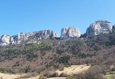
Ruta Senderismo de 10,2 km a descubrir en Auvergne-Rhône-Alpes, Drôme, Saint-Vincent-la-Commanderie. Esta ruta ha sido propuesta por junique.
Descripción
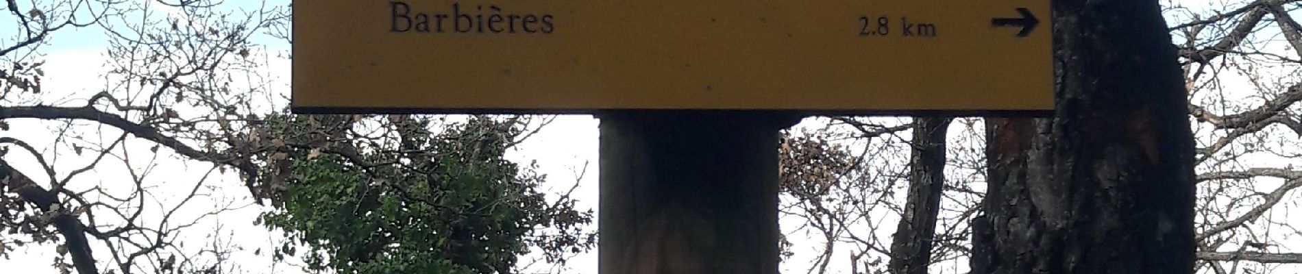
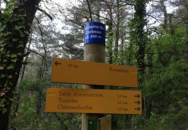
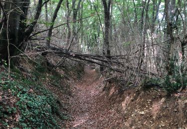
Se garer à côté de l'ecole En haut du village prendre à gauche rue du moulin. Montée rapide la 1ere heure. puis retour par des chemin, très ravinės, avant d'atteindre la route. Redescendre par les gorges.
Localización
País:
France
Región :
Auvergne-Rhône-Alpes
Departamento/provincia :
Drôme
Municipio :
Saint-Vincent-la-Commanderie
Localidad:
Unknown
Salida:(Dec)
Salida:(UTM)
666946 ; 4978360 (31T) N.
Comentarios
Excursiones cerca
![Excursión Senderismo Rochefort-Samson - Les Vachères - Combe d'oyans - Photo](https://media.geolcdn.com/t/375/260/b496d0d5-f9c5-4087-8105-422c092be197.jpg&format=jpg&maxdim=2)
![Senderismo Senderismo](https://static1.geolcdn.com/sitytour/trail-icons/101.png)
Les Vachères - Combe d'oyans
Senderismo
Difícil
(1)
Rochefort-Samson,
Auvergne-Rhône-Alpes,
Drôme,
France
![](/images/other/stat-length.png)
17,1 km | 28 km-effort
8h 26min
![](https://static1.geolcdn.com/siteimages/upload/files/16400158638029165_repeat_loop_refresh_sync_direction_icon.png)
Sí
![Excursión Senderismo Châteaudouble - Le pont des sarazins par la fontaine des corbeaux - Photo](https://media.geolcdn.com/t/375/260/1f3934ff-cd5e-4a15-93b4-c6f716008382.jpg&format=jpg&maxdim=2)
![Senderismo Senderismo](https://static1.geolcdn.com/sitytour/trail-icons/101.png)
Le pont des sarazins par la fontaine des corbeaux
Senderismo
Medio
(1)
Châteaudouble,
Auvergne-Rhône-Alpes,
Drôme,
France
![](/images/other/stat-length.png)
6,4 km | 11,2 km-effort
2h 57min
![](https://static1.geolcdn.com/siteimages/upload/files/16400158638029165_repeat_loop_refresh_sync_direction_icon.png)
No
![Excursión Senderismo Saint-Vincent-la-Commanderie - Pierre Chauve 1308m, les Roches de Treillaras, depuis les Condamines - Photo](https://media.geolcdn.com/t/375/260/ext.jpg?maxdim=2&url=https%3A%2F%2Fservices.sitytrail.com%2FGeolivesWS%2FDownloadMedia.ashx%3FTrailID%3D318111%26Media%3D17572_1.jpg)
![Senderismo Senderismo](https://static1.geolcdn.com/sitytour/trail-icons/101.png)
Pierre Chauve 1308m, les Roches de Treillaras, depuis les Condamines
Senderismo
Medio
(2)
Saint-Vincent-la-Commanderie,
Auvergne-Rhône-Alpes,
Drôme,
France
![](/images/other/stat-length.png)
12,7 km | 25 km-effort
6h 30min
![](https://static1.geolcdn.com/siteimages/upload/files/16400158638029165_repeat_loop_refresh_sync_direction_icon.png)
Sí
![Excursión Senderismo Saint-Vincent-la-Commanderie - 26 st Vincent commanderie zel - Photo](https://media.geolcdn.com/t/375/260/64d0078a-2be9-41db-957b-395e9e3d9a48.jpg&format=jpg&maxdim=2)
![Senderismo Senderismo](https://static1.geolcdn.com/sitytour/trail-icons/101.png)
26 st Vincent commanderie zel
Senderismo
Fácil
Saint-Vincent-la-Commanderie,
Auvergne-Rhône-Alpes,
Drôme,
France
![](/images/other/stat-length.png)
14,2 km | 22 km-effort
6h 5min
![](https://static1.geolcdn.com/siteimages/upload/files/16400158638029165_repeat_loop_refresh_sync_direction_icon.png)
Sí
![Excursión Senderismo Léoncel - les roches de treillaras - Photo](https://media.geolcdn.com/t/375/260/ext.jpg?maxdim=2&url=https%3A%2F%2Fstatic1.geolcdn.com%2Fsiteimages%2Fupload%2Ffiles%2F1553511878bg_sport_marche.png)
![Senderismo Senderismo](https://static1.geolcdn.com/sitytour/trail-icons/101.png)
les roches de treillaras
Senderismo
Fácil
(3)
Léoncel,
Auvergne-Rhône-Alpes,
Drôme,
France
![](/images/other/stat-length.png)
11 km | 16 km-effort
2h 14min
![](https://static1.geolcdn.com/siteimages/upload/files/16400158638029165_repeat_loop_refresh_sync_direction_icon.png)
No
![Excursión Senderismo Léoncel - Rando Pas du touet -rocher de la drayette - Photo](https://media.geolcdn.com/t/375/260/ext.jpg?maxdim=2&url=https%3A%2F%2Fstatic1.geolcdn.com%2Fsiteimages%2Fupload%2Ffiles%2F1553511878bg_sport_marche.png)
![Senderismo Senderismo](https://static1.geolcdn.com/sitytour/trail-icons/101.png)
Rando Pas du touet -rocher de la drayette
Senderismo
Fácil
(3)
Léoncel,
Auvergne-Rhône-Alpes,
Drôme,
France
![](/images/other/stat-length.png)
6,3 km | 8,8 km-effort
2h 11min
![](https://static1.geolcdn.com/siteimages/upload/files/16400158638029165_repeat_loop_refresh_sync_direction_icon.png)
Sí
![Excursión Senderismo Barbières - 26 pierre chauve barbieres zel - Photo](https://media.geolcdn.com/t/375/260/92caf138-cce3-4645-835e-f3491e5ff577.jpg&format=jpg&maxdim=2)
![Senderismo Senderismo](https://static1.geolcdn.com/sitytour/trail-icons/101.png)
26 pierre chauve barbieres zel
Senderismo
Medio
Barbières,
Auvergne-Rhône-Alpes,
Drôme,
France
![](/images/other/stat-length.png)
13,8 km | 26 km-effort
7h 9min
![](https://static1.geolcdn.com/siteimages/upload/files/16400158638029165_repeat_loop_refresh_sync_direction_icon.png)
No
![Excursión Senderismo Barbières - Traversée Barbières Beauregard-Baret - Photo](https://media.geolcdn.com/t/375/260/2a3121e4-a036-4b19-8247-21a832e98ad8.jpg&format=jpg&maxdim=2)
![Senderismo Senderismo](https://static1.geolcdn.com/sitytour/trail-icons/101.png)
Traversée Barbières Beauregard-Baret
Senderismo
Muy difícil
Barbières,
Auvergne-Rhône-Alpes,
Drôme,
France
![](/images/other/stat-length.png)
17 km | 28 km-effort
7h 9min
![](https://static1.geolcdn.com/siteimages/upload/files/16400158638029165_repeat_loop_refresh_sync_direction_icon.png)
No
![Excursión Senderismo Châteaudouble - Chateaudouble pont des sarrasins - Photo](https://media.geolcdn.com/t/375/260/caa67183-ae41-4d78-ba7d-dd614452c162.jpg&format=jpg&maxdim=2)
![Senderismo Senderismo](https://static1.geolcdn.com/sitytour/trail-icons/101.png)
Chateaudouble pont des sarrasins
Senderismo
Medio
Châteaudouble,
Auvergne-Rhône-Alpes,
Drôme,
France
![](/images/other/stat-length.png)
12,6 km | 23 km-effort
3h 42min
![](https://static1.geolcdn.com/siteimages/upload/files/16400158638029165_repeat_loop_refresh_sync_direction_icon.png)
Sí