![](/images/other/stat-length.png)
![Excursión Senderismo Divatte-sur-Loire - Circuit de la haute chapelle - Photo](https://media.geolcdn.com/t/1900/400/ext.pjpeg?maxdim=2&url=https%3A%2F%2Fstatic1.geolcdn.com%2Fsiteimages%2Fupload%2Ffiles%2F1553511878bg_sport_marche.png)
Circuit de la haute chapelle
PhilippeLegault
Usuario
![Longitud](/images/other/stat-length.png)
Longitud
11,8 km
![Altitud máxima](https://static1.geolcdn.com/siteimages/upload/files/1508320355ic_sort_altitude_max_24dp.png)
Altitud máxima
75 m
![Desnivel positivo](https://static1.geolcdn.com/siteimages/upload/files/1508320355ic_sort_den_pos_24dp.png)
Desnivel positivo
145 m
![Km-Effort](/images/other/stat-length.png)
Km-Effort
13,7 km
![Altitud mínima](https://static1.geolcdn.com/siteimages/upload/files/1508320355ic_sort_altitude_min_24dp.png)
Altitud mínima
22 m
![Desnivel negativo](https://static1.geolcdn.com/siteimages/upload/files/1508320355ic_sort_den_neg_24dp.png)
Desnivel negativo
143 m
![Boucle](https://static1.geolcdn.com/siteimages/upload/files/16400158638029165_repeat_loop_refresh_sync_direction_icon.png)
Boucle
Sí
Fecha de creación :
2019-12-15 09:29:36.0
Última modificación :
2019-12-15 13:39:25.655
![Senderismo](https://static1.geolcdn.com/sitytour/trail-icons/101.png)
3h07
Dificultad : Desconocido
![Escanee este código QR para abrir la excursión en la aplicación SityTrail](https://capi.geolives.com/qq0zvz2zws4bq2lad0pu/sitytour/trails/2285183/qr.png?size=200)
Aplicación GPS de excursión GRATIS
A propósito
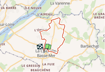
Ruta Senderismo de 11,8 km a descubrir en Países del Loira, Loira-Atlántico, Divatte-sur-Loire. Esta ruta ha sido propuesta por PhilippeLegault.
Descripción
Beaucoup de chemins goudronnés, à faire plutôt l’hiver par temps sec , pas d’abris en chemin.
Localización
País:
France
Región :
Países del Loira
Departamento/provincia :
Loira-Atlántico
Municipio :
Divatte-sur-Loire
Localidad:
Unknown
Salida:(Dec)
Salida:(UTM)
625545 ; 5236726 (30T) N.
Comentarios
Excursiones cerca
![Excursión A pie Divatte-sur-Loire - La Haute Chapelle - Photo](https://media.geolcdn.com/t/375/260/93d8b1e6-c5d6-459b-908b-9d25edfc7517.jpeg&format=jpg&maxdim=2)
![A pie A pie](https://static1.geolcdn.com/sitytour/trail-icons/100.png)
La Haute Chapelle
A pie
Fácil
Divatte-sur-Loire,
Países del Loira,
Loira-Atlántico,
France
![](/images/other/stat-length.png)
10,5 km | 12,4 km-effort
2h 48min
![](https://static1.geolcdn.com/siteimages/upload/files/16400158638029165_repeat_loop_refresh_sync_direction_icon.png)
No
![Excursión A pie Divatte-sur-Loire - La Haute Chapelle (variante) - Photo](https://media.geolcdn.com/t/375/260/93d8b1e6-c5d6-459b-908b-9d25edfc7517.jpeg&format=jpg&maxdim=2)
![A pie A pie](https://static1.geolcdn.com/sitytour/trail-icons/100.png)
La Haute Chapelle (variante)
A pie
Fácil
Divatte-sur-Loire,
Países del Loira,
Loira-Atlántico,
France
![](/images/other/stat-length.png)
9,3 km | 10,7 km-effort
2h 26min
![](https://static1.geolcdn.com/siteimages/upload/files/16400158638029165_repeat_loop_refresh_sync_direction_icon.png)
No
![Excursión Senderismo Divatte-sur-Loire - La Chapelle-Basse-Mer - nord-ouest - Photo](https://media.geolcdn.com/t/375/260/ext.jpg?maxdim=2&url=https%3A%2F%2Fstatic1.geolcdn.com%2Fsiteimages%2Fupload%2Ffiles%2F1553511878bg_sport_marche.png)
![Senderismo Senderismo](https://static1.geolcdn.com/sitytour/trail-icons/101.png)
La Chapelle-Basse-Mer - nord-ouest
Senderismo
Fácil
(1)
Divatte-sur-Loire,
Países del Loira,
Loira-Atlántico,
France
![](/images/other/stat-length.png)
9,1 km | 9,6 km-effort
2h 8min
![](https://static1.geolcdn.com/siteimages/upload/files/16400158638029165_repeat_loop_refresh_sync_direction_icon.png)
Sí
![Excursión Senderismo Le Cellier - Le Cellier 2011-05-22 - Photo](https://media.geolcdn.com/t/375/260/ext.jpg?maxdim=2&url=https%3A%2F%2Fstatic1.geolcdn.com%2Fsiteimages%2Fupload%2Ffiles%2F1553511878bg_sport_marche.png)
![Senderismo Senderismo](https://static1.geolcdn.com/sitytour/trail-icons/101.png)
Le Cellier 2011-05-22
Senderismo
Fácil
(2)
Le Cellier,
Países del Loira,
Loira-Atlántico,
France
![](/images/other/stat-length.png)
16,4 km | 19,9 km-effort
Desconocido
![](https://static1.geolcdn.com/siteimages/upload/files/16400158638029165_repeat_loop_refresh_sync_direction_icon.png)
Sí
![Excursión Senderismo Le Cellier - Randojour1 - Photo](https://media.geolcdn.com/t/375/260/ext.jpg?maxdim=2&url=https%3A%2F%2Fstatic1.geolcdn.com%2Fsiteimages%2Fupload%2Ffiles%2F1553511878bg_sport_marche.png)
![Senderismo Senderismo](https://static1.geolcdn.com/sitytour/trail-icons/101.png)
Randojour1
Senderismo
Difícil
Le Cellier,
Países del Loira,
Loira-Atlántico,
France
![](/images/other/stat-length.png)
10,6 km | 12,7 km-effort
3h 58min
![](https://static1.geolcdn.com/siteimages/upload/files/16400158638029165_repeat_loop_refresh_sync_direction_icon.png)
No
![Excursión Senderismo Mauves-sur-Loire - Mauves - Photo](https://media.geolcdn.com/t/375/260/ext.jpg?maxdim=2&url=https%3A%2F%2Fstatic1.geolcdn.com%2Fsiteimages%2Fupload%2Ffiles%2F1553511878bg_sport_marche.png)
![Senderismo Senderismo](https://static1.geolcdn.com/sitytour/trail-icons/101.png)
Mauves
Senderismo
Difícil
Mauves-sur-Loire,
Países del Loira,
Loira-Atlántico,
France
![](/images/other/stat-length.png)
44 km | 55 km-effort
8h 16min
![](https://static1.geolcdn.com/siteimages/upload/files/16400158638029165_repeat_loop_refresh_sync_direction_icon.png)
Sí
![Excursión Senderismo Le Loroux-Bottereau - Loroux au pont de l’ouzbek - Photo](https://media.geolcdn.com/t/375/260/ext.jpg?maxdim=2&url=https%3A%2F%2Fstatic1.geolcdn.com%2Fsiteimages%2Fupload%2Ffiles%2F1553511878bg_sport_marche.png)
![Senderismo Senderismo](https://static1.geolcdn.com/sitytour/trail-icons/101.png)
Loroux au pont de l’ouzbek
Senderismo
Le Loroux-Bottereau,
Países del Loira,
Loira-Atlántico,
France
![](/images/other/stat-length.png)
12,3 km | 14,1 km-effort
3h 27min
![](https://static1.geolcdn.com/siteimages/upload/files/16400158638029165_repeat_loop_refresh_sync_direction_icon.png)
Sí
![Excursión Senderismo Mauves-sur-Loire - Mauves Le Cellier - Photo](https://media.geolcdn.com/t/375/260/ext.jpg?maxdim=2&url=https%3A%2F%2Fstatic1.geolcdn.com%2Fsiteimages%2Fupload%2Ffiles%2F1553511878bg_sport_marche.png)
![Senderismo Senderismo](https://static1.geolcdn.com/sitytour/trail-icons/101.png)
Mauves Le Cellier
Senderismo
Fácil
Mauves-sur-Loire,
Países del Loira,
Loira-Atlántico,
France
![](/images/other/stat-length.png)
23 km | 28 km-effort
3h 59min
![](https://static1.geolcdn.com/siteimages/upload/files/16400158638029165_repeat_loop_refresh_sync_direction_icon.png)
Sí
![Excursión Bici de carretera Divatte-sur-Loire - TLA Circuit Arrivée Etape 2 - Photo](https://media.geolcdn.com/t/375/260/ext.jpg?maxdim=2&url=https%3A%2F%2Fstatic1.geolcdn.com%2Fsiteimages%2Fupload%2Ffiles%2F1524743154velo.jpg)
![Bici de carretera Bici de carretera](https://static1.geolcdn.com/sitytour/trail-icons/201.png)
TLA Circuit Arrivée Etape 2
Bici de carretera
Medio
Divatte-sur-Loire,
Países del Loira,
Loira-Atlántico,
France
![](/images/other/stat-length.png)
6,4 km | 7,5 km-effort
10min
![](https://static1.geolcdn.com/siteimages/upload/files/16400158638029165_repeat_loop_refresh_sync_direction_icon.png)
Sí