![](/images/other/stat-length.png)
![Excursión Senderismo Le Revest-les-Eaux - tourris le revest par la source de la Ripelle - Photo](https://media.geolcdn.com/t/1900/400/d30bfb19-a776-4f60-8197-ee276ebdcb05.jpg&format=pjpeg&maxdim=2)
tourris le revest par la source de la Ripelle
marchev
Usuario
![Longitud](/images/other/stat-length.png)
Longitud
12,9 km
![Altitud máxima](https://static1.geolcdn.com/siteimages/upload/files/1508320355ic_sort_altitude_max_24dp.png)
Altitud máxima
441 m
![Desnivel positivo](https://static1.geolcdn.com/siteimages/upload/files/1508320355ic_sort_den_pos_24dp.png)
Desnivel positivo
573 m
![Km-Effort](/images/other/stat-length.png)
Km-Effort
21 km
![Altitud mínima](https://static1.geolcdn.com/siteimages/upload/files/1508320355ic_sort_altitude_min_24dp.png)
Altitud mínima
133 m
![Desnivel negativo](https://static1.geolcdn.com/siteimages/upload/files/1508320355ic_sort_den_neg_24dp.png)
Desnivel negativo
570 m
![Boucle](https://static1.geolcdn.com/siteimages/upload/files/16400158638029165_repeat_loop_refresh_sync_direction_icon.png)
Boucle
No
Fecha de creación :
2019-12-05 08:58:17.164
Última modificación :
2019-12-18 13:45:26.5
![Senderismo](https://static1.geolcdn.com/sitytour/trail-icons/101.png)
6h51
Dificultad : Medio
![Escanee este código QR para abrir la excursión en la aplicación SityTrail](https://capi.geolives.com/qq0zvz2zws4bq2lad0pu/sitytour/trails/2279017/qr.png?size=200)
Aplicación GPS de excursión GRATIS
A propósito
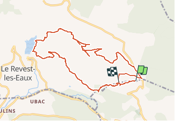
Ruta Senderismo de 12,9 km a descubrir en Provenza-Alpes-Costa Azul, Var, Le Revest-les-Eaux. Esta ruta ha sido propuesta por marchev.
Descripción
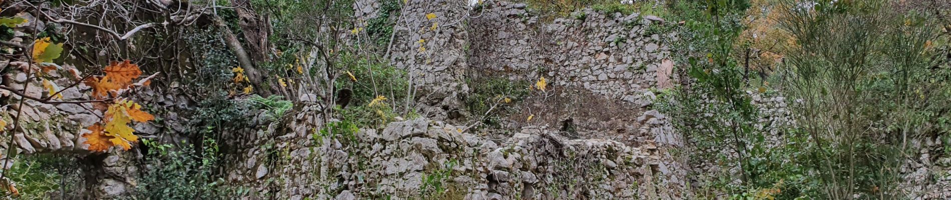
attention il faut modifier la fin de la randonnée. Après la visite du vieux village des Olivières retrouver GR 51, monter sous la ligne électique pour retrouver le château de Tourris et rejoindre la voiture
Localización
País:
France
Región :
Provenza-Alpes-Costa Azul
Departamento/provincia :
Var
Municipio :
Le Revest-les-Eaux
Localidad:
Unknown
Salida:(Dec)
Salida:(UTM)
741311 ; 4783711 (31T) N.
Comentarios
Excursiones cerca
![Excursión Senderismo Le Revest-les-Eaux - Boucle: La ripelle - Source de la ripelle - Le Chateau de Tourris - Les grottes de sable - La carrière aux fourmis - Les puits renovés de M. Lambicchi - Les ruines des Olivières - La ferme de la Touravelle - à Le Revest-les-Eaux - Photo](https://media.geolcdn.com/t/375/260/0dbff04b-2a84-4eed-a6e8-7a56bc074382.jpg&format=jpg&maxdim=2)
![Senderismo Senderismo](https://static1.geolcdn.com/sitytour/trail-icons/101.png)
Boucle: La ripelle - Source de la ripelle - Le Chateau de Tourris - Les grott...
Senderismo
Medio
(1)
Le Revest-les-Eaux,
Provenza-Alpes-Costa Azul,
Var,
France
![](/images/other/stat-length.png)
14,1 km | 21 km-effort
4h 15min
![](https://static1.geolcdn.com/siteimages/upload/files/16400158638029165_repeat_loop_refresh_sync_direction_icon.png)
Sí
![Excursión Senderismo Tolón - Faron versant Nord - Photo](https://media.geolcdn.com/t/375/260/40a1f88d-10a7-4595-84a1-0086eecb7f84.jpg&format=jpg&maxdim=2)
![Senderismo Senderismo](https://static1.geolcdn.com/sitytour/trail-icons/101.png)
Faron versant Nord
Senderismo
Muy difícil
(1)
Tolón,
Provenza-Alpes-Costa Azul,
Var,
France
![](/images/other/stat-length.png)
9,9 km | 17,5 km-effort
6h 38min
![](https://static1.geolcdn.com/siteimages/upload/files/16400158638029165_repeat_loop_refresh_sync_direction_icon.png)
Sí
![Excursión Senderismo Tolón - Faron côté nord - Photo](https://media.geolcdn.com/t/375/260/1a97f987-c174-4fc8-a435-d00586c57288.jpg&format=jpg&maxdim=2)
![Senderismo Senderismo](https://static1.geolcdn.com/sitytour/trail-icons/101.png)
Faron côté nord
Senderismo
Difícil
(1)
Tolón,
Provenza-Alpes-Costa Azul,
Var,
France
![](/images/other/stat-length.png)
4,6 km | 10,1 km-effort
3h 8min
![](https://static1.geolcdn.com/siteimages/upload/files/16400158638029165_repeat_loop_refresh_sync_direction_icon.png)
No
![Excursión Senderismo Solliès-Toucas - Valaury - Apier - Matheron - Photo](https://media.geolcdn.com/t/375/260/f02c0563-7d49-437f-98bb-e34f8a550dee.jpg&format=jpg&maxdim=2)
![Senderismo Senderismo](https://static1.geolcdn.com/sitytour/trail-icons/101.png)
Valaury - Apier - Matheron
Senderismo
Medio
(1)
Solliès-Toucas,
Provenza-Alpes-Costa Azul,
Var,
France
![](/images/other/stat-length.png)
13,1 km | 19,5 km-effort
5h 0min
![](https://static1.geolcdn.com/siteimages/upload/files/16400158638029165_repeat_loop_refresh_sync_direction_icon.png)
Sí
![Excursión Senderismo Le Revest-les-Eaux - 83 barrage revest les eaux 24-05-2021 - Photo](https://media.geolcdn.com/t/375/260/1106c6f7-fedf-4077-96a1-b48580038b53.jpg&format=jpg&maxdim=2)
![Senderismo Senderismo](https://static1.geolcdn.com/sitytour/trail-icons/101.png)
83 barrage revest les eaux 24-05-2021
Senderismo
Medio
(1)
Le Revest-les-Eaux,
Provenza-Alpes-Costa Azul,
Var,
France
![](/images/other/stat-length.png)
8 km | 12,3 km-effort
3h 41min
![](https://static1.geolcdn.com/siteimages/upload/files/16400158638029165_repeat_loop_refresh_sync_direction_icon.png)
Sí
![Excursión Senderismo La Valette-du-Var - SityTrail - Le tour du coudon - Photo](https://media.geolcdn.com/t/375/260/c1a593ce-5178-4a51-a2b4-9401a3556db4.jpg&format=jpg&maxdim=2)
![Senderismo Senderismo](https://static1.geolcdn.com/sitytour/trail-icons/101.png)
SityTrail - Le tour du coudon
Senderismo
Difícil
(1)
La Valette-du-Var,
Provenza-Alpes-Costa Azul,
Var,
France
![](/images/other/stat-length.png)
11,9 km | 19,4 km-effort
5h 0min
![](https://static1.geolcdn.com/siteimages/upload/files/16400158638029165_repeat_loop_refresh_sync_direction_icon.png)
Sí
![Excursión Senderismo Le Revest-les-Eaux - Boucle: Ripelle - Touravelle - Ruines des olivieres - Carrière aux fourmis - Grottes de sables - Vieille valette - Tourris - Source - Ripelle - Photo](https://media.geolcdn.com/t/375/260/ext.jpg?maxdim=2&url=https%3A%2F%2Fstatic1.geolcdn.com%2Fsiteimages%2Fupload%2Ffiles%2F1553511878bg_sport_marche.png)
![Senderismo Senderismo](https://static1.geolcdn.com/sitytour/trail-icons/101.png)
Boucle: Ripelle - Touravelle - Ruines des olivieres - Carrière aux fourmis ...
Senderismo
Medio
(1)
Le Revest-les-Eaux,
Provenza-Alpes-Costa Azul,
Var,
France
![](/images/other/stat-length.png)
13,4 km | 19,4 km-effort
5h 0min
![](https://static1.geolcdn.com/siteimages/upload/files/16400158638029165_repeat_loop_refresh_sync_direction_icon.png)
Sí
![Excursión Senderismo Solliès-Toucas - couvent St Hubert Valaury - Photo](https://media.geolcdn.com/t/375/260/ext.jpg?maxdim=2&url=https%3A%2F%2Fservices.sitytrail.com%2FGeolivesWS%2FDownloadMedia.ashx%3FTrailID%3D361125%26Media%3Dfix__20141108152604.jpg)
![Senderismo Senderismo](https://static1.geolcdn.com/sitytour/trail-icons/101.png)
couvent St Hubert Valaury
Senderismo
Muy fácil
(2)
Solliès-Toucas,
Provenza-Alpes-Costa Azul,
Var,
France
![](/images/other/stat-length.png)
12,5 km | 19,2 km-effort
4h 30min
![](https://static1.geolcdn.com/siteimages/upload/files/16400158638029165_repeat_loop_refresh_sync_direction_icon.png)
Sí
![Excursión Senderismo La Valette-du-Var - SityTrail - Le Revest - Tourris - Confinement 04 2021 - Photo](https://media.geolcdn.com/t/375/260/79fe425d-11d9-4d0f-acb5-646a4a616c9e.jpg&format=jpg&maxdim=2)
![Senderismo Senderismo](https://static1.geolcdn.com/sitytour/trail-icons/101.png)
SityTrail - Le Revest - Tourris - Confinement 04 2021
Senderismo
Fácil
La Valette-du-Var,
Provenza-Alpes-Costa Azul,
Var,
France
![](/images/other/stat-length.png)
11,8 km | 18,8 km-effort
7h 0min
![](https://static1.geolcdn.com/siteimages/upload/files/16400158638029165_repeat_loop_refresh_sync_direction_icon.png)
Sí