![](/images/other/stat-length.png)
![Excursión Hénouville - 2019-11-25_13h58m16_Cirkwi-Le_tour_d_Hénouville - Photo](https://media.geolcdn.com/t/1900/400/ext.pjpeg?maxdim=2&url=https%3A%2F%2Fsecurestorage.geolives.com%2Fsitytour%2Ftrail-bg%2Fdefault.jpg)
2019-11-25_13h58m16_Cirkwi-Le_tour_d_Hénouville
nicole.reine@wanadoo.fr
Usuario
![Longitud](/images/other/stat-length.png)
Longitud
10,1 km
![Altitud máxima](https://static1.geolcdn.com/siteimages/upload/files/1508320355ic_sort_altitude_max_24dp.png)
Altitud máxima
138 m
![Desnivel positivo](https://static1.geolcdn.com/siteimages/upload/files/1508320355ic_sort_den_pos_24dp.png)
Desnivel positivo
93 m
![Km-Effort](/images/other/stat-length.png)
Km-Effort
11,3 km
![Altitud mínima](https://static1.geolcdn.com/siteimages/upload/files/1508320355ic_sort_altitude_min_24dp.png)
Altitud mínima
107 m
![Desnivel negativo](https://static1.geolcdn.com/siteimages/upload/files/1508320355ic_sort_den_neg_24dp.png)
Desnivel negativo
96 m
![Boucle](https://static1.geolcdn.com/siteimages/upload/files/16400158638029165_repeat_loop_refresh_sync_direction_icon.png)
Boucle
Sí
Fecha de creación :
2019-11-25 12:58:17.03
Última modificación :
2019-11-25 12:58:18.148
![Escanee este código QR para abrir la excursión en la aplicación SityTrail](https://capi.geolives.com/qq0zvz2zws4bq2lad0pu/sitytour/trails/2271818/qr.png?size=200)
Aplicación GPS de excursión GRATIS
A propósito
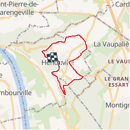
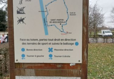
Ruta de 10,1 km a descubrir en Normandía, Sena-Marítimo, Hénouville. Esta ruta ha sido propuesta por nicole.reine@wanadoo.fr.
Descripción
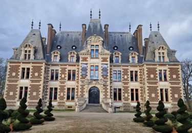
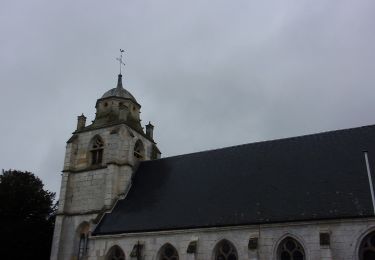
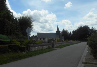
Oxygénez-vous sur cette randonnée qui propose au départ du village d'Hénouville un environnement diversifié entre prairies et forêt.
Localización
País:
France
Región :
Normandía
Departamento/provincia :
Sena-Marítimo
Municipio :
Hénouville
Localidad:
Unknown
Salida:(Dec)
Salida:(UTM)
352132 ; 5482310 (31U) N.
Comentarios
Excursiones cerca
![Excursión Senderismo Saint-Martin-de-Boscherville - Les Marais - St Martin de Boscherville - Photo](https://media.geolcdn.com/t/375/260/ext.jpg?maxdim=2&url=https%3A%2F%2Fservices.sitytrail.com%2FGeolivesWS%2FDownloadMedia.ashx%3FTrailID%3D105880%26Media%3D9864_1.jpg)
![Senderismo Senderismo](https://static1.geolcdn.com/sitytour/trail-icons/101.png)
Les Marais - St Martin de Boscherville
Senderismo
Medio
(1)
Saint-Martin-de-Boscherville,
Normandía,
Sena-Marítimo,
France
![](/images/other/stat-length.png)
11,5 km | 13,8 km-effort
2h 30min
![](https://static1.geolcdn.com/siteimages/upload/files/16400158638029165_repeat_loop_refresh_sync_direction_icon.png)
Sí
![Excursión Senderismo Saint-Pierre-de-Varengeville - La voie verte au Paulu - Photo](https://media.geolcdn.com/t/375/260/ext.jpg?maxdim=2&url=https%3A%2F%2Fstatic1.geolcdn.com%2Fsiteimages%2Fupload%2Ffiles%2F1553511878bg_sport_marche.png)
![Senderismo Senderismo](https://static1.geolcdn.com/sitytour/trail-icons/101.png)
La voie verte au Paulu
Senderismo
Fácil
(1)
Saint-Pierre-de-Varengeville,
Normandía,
Sena-Marítimo,
France
![](/images/other/stat-length.png)
4,9 km | 6 km-effort
1h 18min
![](https://static1.geolcdn.com/siteimages/upload/files/16400158638029165_repeat_loop_refresh_sync_direction_icon.png)
Sí
![Excursión Senderismo Saint-Pierre-de-Varengeville - Boucle du Paulu à Duclair - Photo](https://media.geolcdn.com/t/375/260/ext.jpg?maxdim=2&url=https%3A%2F%2Fstatic1.geolcdn.com%2Fsiteimages%2Fupload%2Ffiles%2F1553511878bg_sport_marche.png)
![Senderismo Senderismo](https://static1.geolcdn.com/sitytour/trail-icons/101.png)
Boucle du Paulu à Duclair
Senderismo
Difícil
(1)
Saint-Pierre-de-Varengeville,
Normandía,
Sena-Marítimo,
France
![](/images/other/stat-length.png)
13,1 km | 16,2 km-effort
3h 29min
![](https://static1.geolcdn.com/siteimages/upload/files/16400158638029165_repeat_loop_refresh_sync_direction_icon.png)
Sí
![Excursión Senderismo Saint-Pierre-de-Varengeville - Autour du Paulu - Photo](https://media.geolcdn.com/t/375/260/ext.jpg?maxdim=2&url=https%3A%2F%2Fstatic1.geolcdn.com%2Fsiteimages%2Fupload%2Ffiles%2F1553511878bg_sport_marche.png)
![Senderismo Senderismo](https://static1.geolcdn.com/sitytour/trail-icons/101.png)
Autour du Paulu
Senderismo
Fácil
(1)
Saint-Pierre-de-Varengeville,
Normandía,
Sena-Marítimo,
France
![](/images/other/stat-length.png)
4,2 km | 5,7 km-effort
1h 13min
![](https://static1.geolcdn.com/siteimages/upload/files/16400158638029165_repeat_loop_refresh_sync_direction_icon.png)
Sí
![Excursión Senderismo Bardouville - bardouville - Photo](https://media.geolcdn.com/t/375/260/ext.jpg?maxdim=2&url=https%3A%2F%2Fstatic1.geolcdn.com%2Fsiteimages%2Fupload%2Ffiles%2F1553511878bg_sport_marche.png)
![Senderismo Senderismo](https://static1.geolcdn.com/sitytour/trail-icons/101.png)
bardouville
Senderismo
Muy fácil
(1)
Bardouville,
Normandía,
Sena-Marítimo,
France
![](/images/other/stat-length.png)
6,1 km | 6,9 km-effort
1h 31min
![](https://static1.geolcdn.com/siteimages/upload/files/16400158638029165_repeat_loop_refresh_sync_direction_icon.png)
Sí
![Excursión Senderismo Saint-Pierre-de-Varengeville - 20240229-St Pierre de Varengeville - Photo](https://media.geolcdn.com/t/375/260/7008d225-ca6d-481f-b5f8-66a30a344d21.jpg&format=jpg&maxdim=2)
![Senderismo Senderismo](https://static1.geolcdn.com/sitytour/trail-icons/101.png)
20240229-St Pierre de Varengeville
Senderismo
Medio
Saint-Pierre-de-Varengeville,
Normandía,
Sena-Marítimo,
France
![](/images/other/stat-length.png)
12,5 km | 15 km-effort
3h 6min
![](https://static1.geolcdn.com/siteimages/upload/files/16400158638029165_repeat_loop_refresh_sync_direction_icon.png)
Sí
![Senderismo Senderismo](https://static1.geolcdn.com/sitytour/trail-icons/101.png)
20240125-Hénouville
Senderismo
Medio
Hénouville,
Normandía,
Sena-Marítimo,
France
![](/images/other/stat-length.png)
10 km | 11,3 km-effort
2h 29min
![](https://static1.geolcdn.com/siteimages/upload/files/16400158638029165_repeat_loop_refresh_sync_direction_icon.png)
Sí
![Senderismo Senderismo](https://static1.geolcdn.com/sitytour/trail-icons/101.png)
20230711-Montigny
Senderismo
Medio
Montigny,
Normandía,
Sena-Marítimo,
France
![](/images/other/stat-length.png)
12,4 km | 16,2 km-effort
3h 37min
![](https://static1.geolcdn.com/siteimages/upload/files/16400158638029165_repeat_loop_refresh_sync_direction_icon.png)
Sí
![Excursión Senderismo Saint-Martin-de-Boscherville - Saint-Martin de Boscherville - Photo](https://media.geolcdn.com/t/375/260/c2618aee-21a6-4f48-8776-58731e18a89d.jpg&format=jpg&maxdim=2)
![Senderismo Senderismo](https://static1.geolcdn.com/sitytour/trail-icons/101.png)
Saint-Martin de Boscherville
Senderismo
Medio
Saint-Martin-de-Boscherville,
Normandía,
Sena-Marítimo,
France
![](/images/other/stat-length.png)
15,3 km | 18,9 km-effort
4h 12min
![](https://static1.geolcdn.com/siteimages/upload/files/16400158638029165_repeat_loop_refresh_sync_direction_icon.png)
Sí