![](/images/other/stat-length.png)
![Excursión Senderismo Goussainville - Goussainville Luzarches-24-11-19 - Photo](https://media.geolcdn.com/t/1900/400/ext.pjpeg?maxdim=2&url=https%3A%2F%2Fstatic1.geolcdn.com%2Fsiteimages%2Fupload%2Ffiles%2F1553511878bg_sport_marche.png)
Goussainville Luzarches-24-11-19
Pascal_M44
Usuario
![Longitud](/images/other/stat-length.png)
Longitud
24 km
![Altitud máxima](https://static1.geolcdn.com/siteimages/upload/files/1508320355ic_sort_altitude_max_24dp.png)
Altitud máxima
139 m
![Desnivel positivo](https://static1.geolcdn.com/siteimages/upload/files/1508320355ic_sort_den_pos_24dp.png)
Desnivel positivo
276 m
![Km-Effort](/images/other/stat-length.png)
Km-Effort
28 km
![Altitud mínima](https://static1.geolcdn.com/siteimages/upload/files/1508320355ic_sort_altitude_min_24dp.png)
Altitud mínima
50 m
![Desnivel negativo](https://static1.geolcdn.com/siteimages/upload/files/1508320355ic_sort_den_neg_24dp.png)
Desnivel negativo
297 m
![Boucle](https://static1.geolcdn.com/siteimages/upload/files/16400158638029165_repeat_loop_refresh_sync_direction_icon.png)
Boucle
No
Fecha de creación :
2019-11-24 08:47:59.35
Última modificación :
2019-11-25 10:20:29.185
![Senderismo](https://static1.geolcdn.com/sitytour/trail-icons/101.png)
6h50
Dificultad : Fácil
![Escanee este código QR para abrir la excursión en la aplicación SityTrail](https://capi.geolives.com/qq0zvz2zws4bq2lad0pu/sitytour/trails/2271188/qr.png?size=200)
Aplicación GPS de excursión GRATIS
A propósito
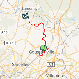
Ruta Senderismo de 24 km a descubrir en Isla de Francia, Valle del Oise, Goussainville. Esta ruta ha sido propuesta por Pascal_M44.
Descripción
Louvres, Château d'Hérivaux, Église de Luzarches
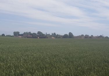
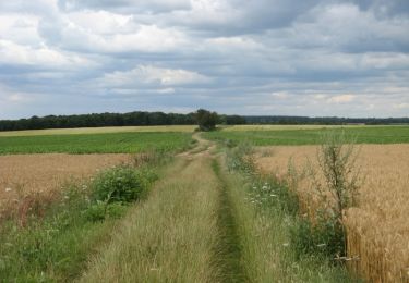
Quelques passages boueux dans les champs
Localización
País:
France
Región :
Isla de Francia
Departamento/provincia :
Valle del Oise
Municipio :
Goussainville
Localidad:
Unknown
Salida:(Dec)
Salida:(UTM)
460747 ; 5430259 (31U) N.
Comentarios
Excursiones cerca
![Excursión Senderismo Puiseux-en-France - CRAB : Puiseux en France Village - Photo](https://media.geolcdn.com/t/375/260/ext.jpg?maxdim=2&url=https%3A%2F%2Fservices.sitytrail.com%2FGeolivesWS%2FDownloadMedia.ashx%3FTrailID%3D771008%26Media%3Dfix__20170611154712.jpg)
![Senderismo Senderismo](https://static1.geolcdn.com/sitytour/trail-icons/101.png)
CRAB : Puiseux en France Village
Senderismo
Fácil
Puiseux-en-France,
Isla de Francia,
Valle del Oise,
France
![](/images/other/stat-length.png)
21 km | 25 km-effort
5h 34min
![](https://static1.geolcdn.com/siteimages/upload/files/16400158638029165_repeat_loop_refresh_sync_direction_icon.png)
Sí
![Excursión Bici de montaña Châtenay-en-France - Châtenay en France - Photo](https://media.geolcdn.com/t/375/260/ext.jpg?maxdim=2&url=https%3A%2F%2Fservices.sitytrail.com%2FGeolivesWS%2FDownloadMedia.ashx%3FTrailID%3D106251%26Media%3D10586_3.jpg)
![Bici de montaña Bici de montaña](https://static1.geolcdn.com/sitytour/trail-icons/202.png)
Châtenay en France
Bici de montaña
Medio
(1)
Châtenay-en-France,
Isla de Francia,
Valle del Oise,
France
![](/images/other/stat-length.png)
18,7 km | 22 km-effort
1h 30min
![](https://static1.geolcdn.com/siteimages/upload/files/16400158638029165_repeat_loop_refresh_sync_direction_icon.png)
Sí
![Excursión Senderismo Châtenay-en-France - Châtenay en France - Photo](https://media.geolcdn.com/t/375/260/ext.jpg?maxdim=2&url=https%3A%2F%2Fservices.sitytrail.com%2FGeolivesWS%2FDownloadMedia.ashx%3FTrailID%3D106250%26Media%3D10586_3.jpg)
![Senderismo Senderismo](https://static1.geolcdn.com/sitytour/trail-icons/101.png)
Châtenay en France
Senderismo
Medio
Châtenay-en-France,
Isla de Francia,
Valle del Oise,
France
![](/images/other/stat-length.png)
18,7 km | 22 km-effort
5h 0min
![](https://static1.geolcdn.com/siteimages/upload/files/16400158638029165_repeat_loop_refresh_sync_direction_icon.png)
Sí
![Excursión Senderismo Châtenay-en-France - chatenay - Photo](https://media.geolcdn.com/t/375/260/ext.jpg?maxdim=2&url=https%3A%2F%2Fstatic1.geolcdn.com%2Fsiteimages%2Fupload%2Ffiles%2F1553511878bg_sport_marche.png)
![Senderismo Senderismo](https://static1.geolcdn.com/sitytour/trail-icons/101.png)
chatenay
Senderismo
Muy difícil
Châtenay-en-France,
Isla de Francia,
Valle del Oise,
France
![](/images/other/stat-length.png)
21 km | 24 km-effort
5h 48min
![](https://static1.geolcdn.com/siteimages/upload/files/16400158638029165_repeat_loop_refresh_sync_direction_icon.png)
Sí
![Excursión Senderismo Roissy-en-France - GOLF ROISSY - Photo](https://media.geolcdn.com/t/375/260/ext.jpg?maxdim=2&url=https%3A%2F%2Fstatic1.geolcdn.com%2Fsiteimages%2Fupload%2Ffiles%2F1553511878bg_sport_marche.png)
![Senderismo Senderismo](https://static1.geolcdn.com/sitytour/trail-icons/101.png)
GOLF ROISSY
Senderismo
Medio
Roissy-en-France,
Isla de Francia,
Valle del Oise,
France
![](/images/other/stat-length.png)
7,9 km | 8,8 km-effort
2h 0min
![](https://static1.geolcdn.com/siteimages/upload/files/16400158638029165_repeat_loop_refresh_sync_direction_icon.png)
Sí
![Excursión Senderismo Fontenay-en-Parisis - fontenay - Photo](https://media.geolcdn.com/t/375/260/ext.jpg?maxdim=2&url=https%3A%2F%2Fstatic1.geolcdn.com%2Fsiteimages%2Fupload%2Ffiles%2F1553511878bg_sport_marche.png)
![Senderismo Senderismo](https://static1.geolcdn.com/sitytour/trail-icons/101.png)
fontenay
Senderismo
Difícil
Fontenay-en-Parisis,
Isla de Francia,
Valle del Oise,
France
![](/images/other/stat-length.png)
13,7 km | 15,8 km-effort
3h 18min
![](https://static1.geolcdn.com/siteimages/upload/files/16400158638029165_repeat_loop_refresh_sync_direction_icon.png)
Sí
![Excursión Senderismo Arnouville - 23 novembre 2019 - Photo](https://media.geolcdn.com/t/375/260/ext.jpg?maxdim=2&url=https%3A%2F%2Fstatic1.geolcdn.com%2Fsiteimages%2Fupload%2Ffiles%2F1553511878bg_sport_marche.png)
![Senderismo Senderismo](https://static1.geolcdn.com/sitytour/trail-icons/101.png)
23 novembre 2019
Senderismo
Muy fácil
Arnouville,
Isla de Francia,
Valle del Oise,
France
![](/images/other/stat-length.png)
12,3 km | 13,6 km-effort
3h 40min
![](https://static1.geolcdn.com/siteimages/upload/files/16400158638029165_repeat_loop_refresh_sync_direction_icon.png)
Sí
![Excursión Senderismo Le Thillay - le thillay 2 novembre 2021 - Photo](https://media.geolcdn.com/t/375/260/ext.jpg?maxdim=2&url=https%3A%2F%2Fstatic1.geolcdn.com%2Fsiteimages%2Fupload%2Ffiles%2F1553511878bg_sport_marche.png)
![Senderismo Senderismo](https://static1.geolcdn.com/sitytour/trail-icons/101.png)
le thillay 2 novembre 2021
Senderismo
Muy fácil
Le Thillay,
Isla de Francia,
Valle del Oise,
France
![](/images/other/stat-length.png)
6,9 km | 7,9 km-effort
2h 57min
![](https://static1.geolcdn.com/siteimages/upload/files/16400158638029165_repeat_loop_refresh_sync_direction_icon.png)
Sí
![Excursión Senderismo Gonesse - genèse pompier 3 10 2021 - Photo](https://media.geolcdn.com/t/375/260/ext.jpg?maxdim=2&url=https%3A%2F%2Fstatic1.geolcdn.com%2Fsiteimages%2Fupload%2Ffiles%2F1553511878bg_sport_marche.png)
![Senderismo Senderismo](https://static1.geolcdn.com/sitytour/trail-icons/101.png)
genèse pompier 3 10 2021
Senderismo
Muy fácil
Gonesse,
Isla de Francia,
Valle del Oise,
France
![](/images/other/stat-length.png)
13,7 km | 15,4 km-effort
2h 57min
![](https://static1.geolcdn.com/siteimages/upload/files/16400158638029165_repeat_loop_refresh_sync_direction_icon.png)
Sí