![](/images/other/stat-length.png)
![Excursión Motocross Lentegí - Lentegi Vélez de Benaudalla - Photo](https://media.geolcdn.com/t/1900/400/82f69f2a-fa53-4f07-aef5-63c3aeaa5dc3.jpg&format=pjpeg&maxdim=2)
Lentegi Vélez de Benaudalla
jpipacific
Usuario
![Longitud](/images/other/stat-length.png)
Longitud
74 km
![Altitud máxima](https://static1.geolcdn.com/siteimages/upload/files/1508320355ic_sort_altitude_max_24dp.png)
Altitud máxima
1340 m
![Desnivel positivo](https://static1.geolcdn.com/siteimages/upload/files/1508320355ic_sort_den_pos_24dp.png)
Desnivel positivo
2115 m
![Km-Effort](/images/other/stat-length.png)
Km-Effort
104 km
![Altitud mínima](https://static1.geolcdn.com/siteimages/upload/files/1508320355ic_sort_altitude_min_24dp.png)
Altitud mínima
94 m
![Desnivel negativo](https://static1.geolcdn.com/siteimages/upload/files/1508320355ic_sort_den_neg_24dp.png)
Desnivel negativo
2479 m
![Boucle](https://static1.geolcdn.com/siteimages/upload/files/16400158638029165_repeat_loop_refresh_sync_direction_icon.png)
Boucle
No
Fecha de creación :
2019-11-18 11:13:11.48
Última modificación :
2019-11-18 17:18:20.66
![Motocross](https://static1.geolcdn.com/sitytour/trail-icons/406.png)
2h31
Dificultad : Muy fácil
![Escanee este código QR para abrir la excursión en la aplicación SityTrail](https://capi.geolives.com/qq0zvz2zws4bq2lad0pu/sitytour/trails/2267169/qr.png?size=200)
Aplicación GPS de excursión GRATIS
A propósito
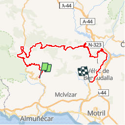
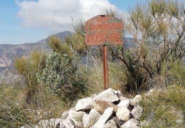
Ruta Motocross de 74 km a descubrir en Andalucía, Granada, Lentegí. Esta ruta ha sido propuesta por jpipacific.
Descripción
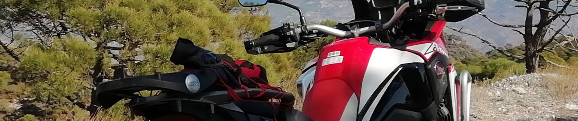
Le 18 novembre 2019 Honda Africa Twin CRF 1000
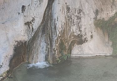
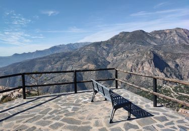
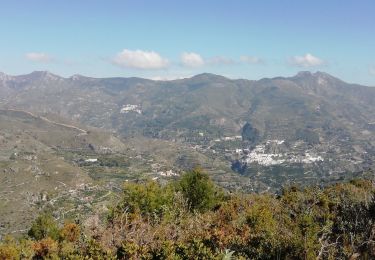
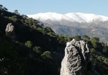
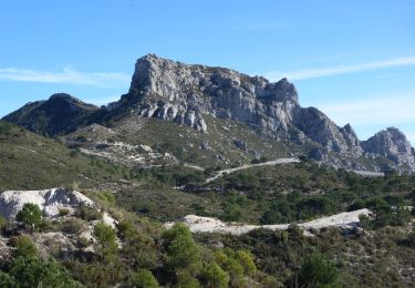
Magnifique randonnée . Des paysages splendides et gigantesques. Vue superbe sur la Sierra Nevada enneigée.
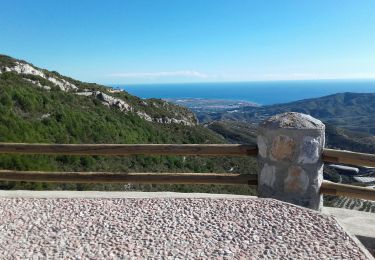
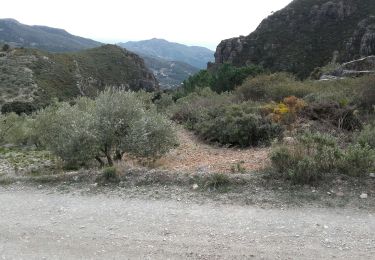
Une descente après les crêtes un peu pentue mais rien de bien méchant
Localización
País:
Spain
Región :
Andalucía
Departamento/provincia :
Granada
Municipio :
Lentegí
Localidad:
Unknown
Salida:(Dec)
Salida:(UTM)
439310 ; 4075448 (30S) N.
Comentarios
Excursiones cerca
![Excursión Senderismo Lentegí - Poza de las animas - Photo](https://media.geolcdn.com/t/375/260/138d79bf-c8e6-4959-ad11-fb1767b7d5eb.jpg&format=jpg&maxdim=2)
![Senderismo Senderismo](https://static1.geolcdn.com/sitytour/trail-icons/101.png)
Poza de las animas
Senderismo
Medio
(1)
Lentegí,
Andalucía,
Granada,
Spain
![](/images/other/stat-length.png)
5,4 km | 9,5 km-effort
2h 42min
![](https://static1.geolcdn.com/siteimages/upload/files/16400158638029165_repeat_loop_refresh_sync_direction_icon.png)
Sí
![Excursión Senderismo Lentegí - Lentegi Las Bizarras - Photo](https://media.geolcdn.com/t/375/260/6e3b7bc9-1a0d-4a1d-bbbf-2f25e6bc75de.jpg&format=jpg&maxdim=2)
![Senderismo Senderismo](https://static1.geolcdn.com/sitytour/trail-icons/101.png)
Lentegi Las Bizarras
Senderismo
Medio
Lentegí,
Andalucía,
Granada,
Spain
![](/images/other/stat-length.png)
8,5 km | 13,9 km-effort
3h 51min
![](https://static1.geolcdn.com/siteimages/upload/files/16400158638029165_repeat_loop_refresh_sync_direction_icon.png)
Sí
![Excursión Senderismo Otívar - OTIVAR Castillo Moscaril - Photo](https://media.geolcdn.com/t/375/260/0f691502-7702-4e97-b4a7-20ff68f93bf9.jpg&format=jpg&maxdim=2)
![Senderismo Senderismo](https://static1.geolcdn.com/sitytour/trail-icons/101.png)
OTIVAR Castillo Moscaril
Senderismo
Medio
Otívar,
Andalucía,
Granada,
Spain
![](/images/other/stat-length.png)
4,1 km | 6,5 km-effort
1h 58min
![](https://static1.geolcdn.com/siteimages/upload/files/16400158638029165_repeat_loop_refresh_sync_direction_icon.png)
Sí
![Excursión Senderismo Lentegí - les arbres petrifies - Photo](https://media.geolcdn.com/t/375/260/0b9d6321-13d8-4551-a0f4-c4e1d276d87a.jpg&format=jpg&maxdim=2)
![Senderismo Senderismo](https://static1.geolcdn.com/sitytour/trail-icons/101.png)
les arbres petrifies
Senderismo
Difícil
Lentegí,
Andalucía,
Granada,
Spain
![](/images/other/stat-length.png)
9,5 km | 15 km-effort
3h 46min
![](https://static1.geolcdn.com/siteimages/upload/files/16400158638029165_repeat_loop_refresh_sync_direction_icon.png)
Sí
![Excursión Senderismo Ítrabo - Itrabo Ruta de Al Idrisi - Photo](https://media.geolcdn.com/t/375/260/21578a9f-3edf-4fad-8de4-73ade5f6a513.jpg&format=jpg&maxdim=2)
![Senderismo Senderismo](https://static1.geolcdn.com/sitytour/trail-icons/101.png)
Itrabo Ruta de Al Idrisi
Senderismo
Medio
Ítrabo,
Andalucía,
Granada,
Spain
![](/images/other/stat-length.png)
8,2 km | 12,7 km-effort
3h 33min
![](https://static1.geolcdn.com/siteimages/upload/files/16400158638029165_repeat_loop_refresh_sync_direction_icon.png)
Sí
![Excursión Senderismo Ítrabo - Cerro de Itrabo et del Aquila - Photo](https://media.geolcdn.com/t/375/260/4be84b38-1c0d-4979-ae22-e6ac0cc7ce58.jpg&format=jpg&maxdim=2)
![Senderismo Senderismo](https://static1.geolcdn.com/sitytour/trail-icons/101.png)
Cerro de Itrabo et del Aquila
Senderismo
Medio
Ítrabo,
Andalucía,
Granada,
Spain
![](/images/other/stat-length.png)
6,7 km | 10,2 km-effort
1h 50min
![](https://static1.geolcdn.com/siteimages/upload/files/16400158638029165_repeat_loop_refresh_sync_direction_icon.png)
Sí
![Excursión A pie Almuñécar - OTIVAR castillo Moscaril tour 2 - Photo](https://media.geolcdn.com/t/375/260/9f70cda7-72e7-4555-909c-15377c7c2dd6.jpg&format=jpg&maxdim=2)
![A pie A pie](https://static1.geolcdn.com/sitytour/trail-icons/100.png)
OTIVAR castillo Moscaril tour 2
A pie
Medio
Almuñécar,
Andalucía,
Granada,
Spain
![](/images/other/stat-length.png)
3,4 km | 5,7 km-effort
1h 21min
![](https://static1.geolcdn.com/siteimages/upload/files/16400158638029165_repeat_loop_refresh_sync_direction_icon.png)
Sí
![Senderismo Senderismo](https://static1.geolcdn.com/sitytour/trail-icons/101.png)
Molvizar au dessus
Senderismo
Muy fácil
Lentegí,
Andalucía,
Granada,
Spain
![](/images/other/stat-length.png)
7,7 km | 10,9 km-effort
1h 8min
![](https://static1.geolcdn.com/siteimages/upload/files/16400158638029165_repeat_loop_refresh_sync_direction_icon.png)
Sí
![Excursión Senderismo Lentegí - Lentegi 2019 - Photo](https://media.geolcdn.com/t/375/260/a924e236-f249-4f5e-ad92-4ffdbc7fba71.jpg&format=jpg&maxdim=2)
![Senderismo Senderismo](https://static1.geolcdn.com/sitytour/trail-icons/101.png)
Lentegi 2019
Senderismo
Muy fácil
Lentegí,
Andalucía,
Granada,
Spain
![](/images/other/stat-length.png)
5 km | 7,4 km-effort
1h 33min
![](https://static1.geolcdn.com/siteimages/upload/files/16400158638029165_repeat_loop_refresh_sync_direction_icon.png)
Sí