![](/images/other/stat-length.png)
![Excursión Senderismo Saint-Jeannet - Circuit du Castellet et les Baous de St Jeannet - Photo](https://media.geolcdn.com/t/1900/400/ext.pjpeg?maxdim=2&url=https%3A%2F%2Fstatic1.geolcdn.com%2Fsiteimages%2Fupload%2Ffiles%2F1553511878bg_sport_marche.png)
Circuit du Castellet et les Baous de St Jeannet
jmheydorff
Usuario
![Longitud](/images/other/stat-length.png)
![Altitud máxima](https://static1.geolcdn.com/siteimages/upload/files/1508320355ic_sort_altitude_max_24dp.png)
![Desnivel positivo](https://static1.geolcdn.com/siteimages/upload/files/1508320355ic_sort_den_pos_24dp.png)
![Km-Effort](/images/other/stat-length.png)
![Altitud mínima](https://static1.geolcdn.com/siteimages/upload/files/1508320355ic_sort_altitude_min_24dp.png)
![Desnivel negativo](https://static1.geolcdn.com/siteimages/upload/files/1508320355ic_sort_den_neg_24dp.png)
![Boucle](https://static1.geolcdn.com/siteimages/upload/files/16400158638029165_repeat_loop_refresh_sync_direction_icon.png)
![Senderismo](https://static1.geolcdn.com/sitytour/trail-icons/101.png)
4h58
Dificultad : Difícil
![Escanee este código QR para abrir la excursión en la aplicación SityTrail](https://capi.geolives.com/qq0zvz2zws4bq2lad0pu/sitytour/trails/226507/qr.png?size=200)
Aplicación GPS de excursión GRATIS
A propósito
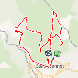
Ruta Senderismo de 13,9 km a descubrir en Provenza-Alpes-Costa Azul, Alpes Marítimos, Saint-Jeannet. Esta ruta ha sido propuesta por jmheydorff.
Descripción
15 kms 800m 5h30 Pkg public gratuit à 420 m d'altitude, à l'arrivée de la D 18, au N du village.
Monter les escaliers, monter S l'av. du Vallon, à dr. la place puis la rue de la Croix; à 30m, monter la rue, puis les escaliers qui traversent la rue du verger et rejoignent le ch. du Baou (Gr 51) que l'on prend N.
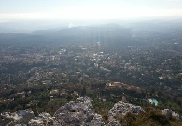
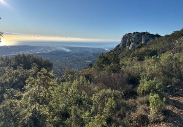
Après 1h30 de montée (alt. 640m), laisser le GR 51 monter à gauche, et prendre le sentier tt droit, qui longe le fond du vallon de Parriau sur 150m, puis monter à dr. (petite sente) jusqu'au bord du Baou de la Gaude 'alt. 796m).
revenir par la même sente, puis continuer N sur la ligne de crête, en passant par La colle (844m); au Clos de l'Evêque (replas), on redescend le vallon jusqu'au GR51 (à l'endroit où on l'a quitté tt à l'heure); on le remonte en NW sur 100m, puis on prend une sente à g. qui passe sous la Grotte Scelo (vastes salles, après la petite entrée); on atteint la table d'orientation du Baou de St-Jeannet à 802 m.
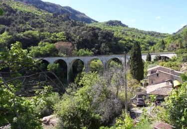
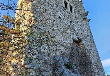
Revenir N en ligne de crête, rejoindre à nouveau le GR 51, que l'on prend en W jusqu'au Château ruiné, d'où on va descendre fortement, puis longer le vallon du Castelet.
Le sentier revient au village de St-Jeannet en longeant le bas de la falaise du Baou. On traverse le village jusqu'au Pkg.
Localización
Comentarios
Excursiones cerca
![Excursión Senderismo Saint-Jeannet - Baou de Saint-Jeannet - Photo](https://media.geolcdn.com/t/375/260/d4c22365-bd73-4ba1-a46d-47812961244f.jpg&format=jpg&maxdim=2)
![Senderismo Senderismo](https://static1.geolcdn.com/sitytour/trail-icons/101.png)
Senderismo
![](/images/other/stat-length.png)
![](https://static1.geolcdn.com/siteimages/upload/files/16400158638029165_repeat_loop_refresh_sync_direction_icon.png)
![Excursión A pie Vence - Circuit des Blaquières - Photo](https://media.geolcdn.com/t/375/260/46014005-cf89-423b-a650-f449be44d3f6.jpeg&format=jpg&maxdim=2)
![A pie A pie](https://static1.geolcdn.com/sitytour/trail-icons/100.png)
A pie
![](/images/other/stat-length.png)
![](https://static1.geolcdn.com/siteimages/upload/files/16400158638029165_repeat_loop_refresh_sync_direction_icon.png)
![Excursión A pie Gattières - Baou de la Gaude - Photo](https://media.geolcdn.com/t/375/260/ab686055-453b-4527-9610-4cf7a5679c21.jpeg&format=jpg&maxdim=2)
![A pie A pie](https://static1.geolcdn.com/sitytour/trail-icons/100.png)
A pie
![](/images/other/stat-length.png)
![](https://static1.geolcdn.com/siteimages/upload/files/16400158638029165_repeat_loop_refresh_sync_direction_icon.png)
![Excursión A pie Carros - Les Balcons de Carros - Photo](https://media.geolcdn.com/t/375/260/a6a71bca-0b2f-4793-9dae-094488c13d6e.jpeg&format=jpg&maxdim=2)
![A pie A pie](https://static1.geolcdn.com/sitytour/trail-icons/100.png)
A pie
![](/images/other/stat-length.png)
![](https://static1.geolcdn.com/siteimages/upload/files/16400158638029165_repeat_loop_refresh_sync_direction_icon.png)
![Excursión A pie Vence - Plan des Noves - Photo](https://media.geolcdn.com/t/375/260/5bdbad17-ece4-4950-8e82-290491f5430d.jpeg&format=jpg&maxdim=2)
![A pie A pie](https://static1.geolcdn.com/sitytour/trail-icons/100.png)
A pie
![](/images/other/stat-length.png)
![](https://static1.geolcdn.com/siteimages/upload/files/16400158638029165_repeat_loop_refresh_sync_direction_icon.png)
![Excursión A pie Saint-Jeannet - Circuit du Castellet - Photo](https://media.geolcdn.com/t/375/260/afc23e4e-bd37-42a8-b455-4fba696582ad.jpeg&format=jpg&maxdim=2)
![A pie A pie](https://static1.geolcdn.com/sitytour/trail-icons/100.png)
A pie
![](/images/other/stat-length.png)
![](https://static1.geolcdn.com/siteimages/upload/files/16400158638029165_repeat_loop_refresh_sync_direction_icon.png)
![Excursión Senderismo Vence - Vence le Baou des Blancs - Photo](https://media.geolcdn.com/t/375/260/ext.jpg?maxdim=2&url=https%3A%2F%2Fservices.sitytrail.com%2FGeolivesWS%2FDownloadMedia.ashx%3FTrailID%3D168755%26Media%3D20130105141841.jpeg)
![Senderismo Senderismo](https://static1.geolcdn.com/sitytour/trail-icons/101.png)
Senderismo
![](/images/other/stat-length.png)
![](https://static1.geolcdn.com/siteimages/upload/files/16400158638029165_repeat_loop_refresh_sync_direction_icon.png)
![Excursión Senderismo Saint-Jeannet - St Jeannet : les Baous janv 2025 - Photo](https://media.geolcdn.com/t/375/260/362b31cc-013f-4b2f-a360-d53c75d51365.jpg&format=jpg&maxdim=2)
![Senderismo Senderismo](https://static1.geolcdn.com/sitytour/trail-icons/101.png)
Senderismo
![](/images/other/stat-length.png)
![](https://static1.geolcdn.com/siteimages/upload/files/16400158638029165_repeat_loop_refresh_sync_direction_icon.png)
![Excursión Senderismo Saint-Jeannet - Baous de la Gaude et de St Jeannet - Photo](https://media.geolcdn.com/t/375/260/3655e9c4-c4c4-495a-bc74-b57cc8e907b9.jpg&format=jpg&maxdim=2)
![Senderismo Senderismo](https://static1.geolcdn.com/sitytour/trail-icons/101.png)
Senderismo
![](/images/other/stat-length.png)
![](https://static1.geolcdn.com/siteimages/upload/files/16400158638029165_repeat_loop_refresh_sync_direction_icon.png)