![](/images/other/stat-length.png)
![Excursión Senderismo Nantes - De Pirmil au Chêne - Photo](https://media.geolcdn.com/t/1900/400/ext.pjpeg?maxdim=2&url=https%3A%2F%2Fstatic1.geolcdn.com%2Fsiteimages%2Fupload%2Ffiles%2F1553511878bg_sport_marche.png)
De Pirmil au Chêne
LeonEvain
Usuario
![Longitud](/images/other/stat-length.png)
Longitud
6,5 km
![Altitud máxima](https://static1.geolcdn.com/siteimages/upload/files/1508320355ic_sort_altitude_max_24dp.png)
Altitud máxima
17 m
![Desnivel positivo](https://static1.geolcdn.com/siteimages/upload/files/1508320355ic_sort_den_pos_24dp.png)
Desnivel positivo
33 m
![Km-Effort](/images/other/stat-length.png)
Km-Effort
7 km
![Altitud mínima](https://static1.geolcdn.com/siteimages/upload/files/1508320355ic_sort_altitude_min_24dp.png)
Altitud mínima
1 m
![Desnivel negativo](https://static1.geolcdn.com/siteimages/upload/files/1508320355ic_sort_den_neg_24dp.png)
Desnivel negativo
35 m
![Boucle](https://static1.geolcdn.com/siteimages/upload/files/16400158638029165_repeat_loop_refresh_sync_direction_icon.png)
Boucle
No
Fecha de creación :
2019-11-13 18:35:09.966
Última modificación :
2020-03-21 16:16:08.321
![Senderismo](https://static1.geolcdn.com/sitytour/trail-icons/101.png)
1h18
Dificultad : Fácil
![Escanee este código QR para abrir la excursión en la aplicación SityTrail](https://capi.geolives.com/qq0zvz2zws4bq2lad0pu/sitytour/trails/2264077/qr.png?size=200)
Aplicación GPS de excursión GRATIS
A propósito
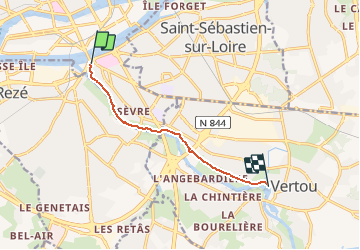
Ruta Senderismo de 6,5 km a descubrir en Países del Loira, Loira-Atlántico, Nantes. Esta ruta ha sido propuesta por LeonEvain.
Descripción
** 07 km ** Aller et retour le long de la Sèvre de la station Tram de Pirmil jusqu'au village typique de la Chaussée aux Moines avec son barrage et ses restaurants
Localización
País:
France
Región :
Países del Loira
Departamento/provincia :
Loira-Atlántico
Municipio :
Nantes
Localidad:
Unknown
Salida:(Dec)
Salida:(UTM)
610424 ; 5228100 (30T) N.
Comentarios
Excursiones cerca
![Excursión Senderismo Nantes - Bords de Sevre nantaise - Photo](https://media.geolcdn.com/t/375/260/ext.jpg?maxdim=2&url=https%3A%2F%2Fstatic1.geolcdn.com%2Fsiteimages%2Fupload%2Ffiles%2F1553511878bg_sport_marche.png)
![Senderismo Senderismo](https://static1.geolcdn.com/sitytour/trail-icons/101.png)
Bords de Sevre nantaise
Senderismo
Muy fácil
(1)
Nantes,
Países del Loira,
Loira-Atlántico,
France
![](/images/other/stat-length.png)
13,7 km | 14,8 km-effort
2h 41min
![](https://static1.geolcdn.com/siteimages/upload/files/16400158638029165_repeat_loop_refresh_sync_direction_icon.png)
Sí
![Excursión Senderismo Rezé - Rezé - nord - Photo](https://media.geolcdn.com/t/375/260/ext.jpg?maxdim=2&url=https%3A%2F%2Fstatic1.geolcdn.com%2Fsiteimages%2Fupload%2Ffiles%2F1553511878bg_sport_marche.png)
![Senderismo Senderismo](https://static1.geolcdn.com/sitytour/trail-icons/101.png)
Rezé - nord
Senderismo
Fácil
(1)
Rezé,
Países del Loira,
Loira-Atlántico,
France
![](/images/other/stat-length.png)
9,5 km | 10,4 km-effort
2h 17min
![](https://static1.geolcdn.com/siteimages/upload/files/16400158638029165_repeat_loop_refresh_sync_direction_icon.png)
Sí
![Excursión Senderismo Nantes - Nantes chezine-chantenay - Photo](https://media.geolcdn.com/t/375/260/ext.jpg?maxdim=2&url=https%3A%2F%2Fstatic1.geolcdn.com%2Fsiteimages%2Fupload%2Ffiles%2F1553511878bg_sport_marche.png)
![Senderismo Senderismo](https://static1.geolcdn.com/sitytour/trail-icons/101.png)
Nantes chezine-chantenay
Senderismo
Muy fácil
(1)
Nantes,
Países del Loira,
Loira-Atlántico,
France
![](/images/other/stat-length.png)
9,5 km | 11,1 km-effort
2h 26min
![](https://static1.geolcdn.com/siteimages/upload/files/16400158638029165_repeat_loop_refresh_sync_direction_icon.png)
Sí
![Excursión Bicicleta Nantes - Nantes San Francisco à Mauves - Photo](https://media.geolcdn.com/t/375/260/ext.jpg?maxdim=2&url=https%3A%2F%2Fstatic1.geolcdn.com%2Fsiteimages%2Fupload%2Ffiles%2F1524743154velo.jpg)
![Bicicleta Bicicleta](https://static1.geolcdn.com/sitytour/trail-icons/200.png)
Nantes San Francisco à Mauves
Bicicleta
Fácil
(2)
Nantes,
Países del Loira,
Loira-Atlántico,
France
![](/images/other/stat-length.png)
33 km | 36 km-effort
2h 6min
![](https://static1.geolcdn.com/siteimages/upload/files/16400158638029165_repeat_loop_refresh_sync_direction_icon.png)
Sí
![Excursión Bici de montaña Nantes - Nantes - Photo](https://media.geolcdn.com/t/375/260/ext.jpg?maxdim=2&url=https%3A%2F%2Fstatic1.geolcdn.com%2Fsiteimages%2Fupload%2Ffiles%2F1524743154velo.jpg)
![Bici de montaña Bici de montaña](https://static1.geolcdn.com/sitytour/trail-icons/202.png)
Nantes
Bici de montaña
Medio
(1)
Nantes,
Países del Loira,
Loira-Atlántico,
France
![](/images/other/stat-length.png)
32 km | 38 km-effort
2h 6min
![](https://static1.geolcdn.com/siteimages/upload/files/16400158638029165_repeat_loop_refresh_sync_direction_icon.png)
Sí
![Excursión Senderismo Bouguenais - Sèvre et Jaguère - Photo](https://media.geolcdn.com/t/375/260/ext.jpg?maxdim=2&url=https%3A%2F%2Fstatic1.geolcdn.com%2Fsiteimages%2Fupload%2Ffiles%2F1553511878bg_sport_marche.png)
![Senderismo Senderismo](https://static1.geolcdn.com/sitytour/trail-icons/101.png)
Sèvre et Jaguère
Senderismo
Muy fácil
(1)
Bouguenais,
Países del Loira,
Loira-Atlántico,
France
![](/images/other/stat-length.png)
13,3 km | 14,6 km-effort
Desconocido
![](https://static1.geolcdn.com/siteimages/upload/files/16400158638029165_repeat_loop_refresh_sync_direction_icon.png)
Sí
![Excursión Senderismo Saint-Sébastien-sur-Loire - Saint Sébastien-sur-Loire, départ stade René Massé - Photo](https://media.geolcdn.com/t/375/260/ext.jpg?maxdim=2&url=https%3A%2F%2Fstatic1.geolcdn.com%2Fsiteimages%2Fupload%2Ffiles%2F1553511878bg_sport_marche.png)
![Senderismo Senderismo](https://static1.geolcdn.com/sitytour/trail-icons/101.png)
Saint Sébastien-sur-Loire, départ stade René Massé
Senderismo
Fácil
(1)
Saint-Sébastien-sur-Loire,
Países del Loira,
Loira-Atlántico,
France
![](/images/other/stat-length.png)
8,2 km | 9 km-effort
2h 23min
![](https://static1.geolcdn.com/siteimages/upload/files/16400158638029165_repeat_loop_refresh_sync_direction_icon.png)
Sí
![Excursión Senderismo Saint-Sébastien-sur-Loire - Saint Sébastien-sur-Loire, départ stade René Massé - Photo](https://media.geolcdn.com/t/375/260/ext.jpg?maxdim=2&url=https%3A%2F%2Fstatic1.geolcdn.com%2Fsiteimages%2Fupload%2Ffiles%2F1553511878bg_sport_marche.png)
![Senderismo Senderismo](https://static1.geolcdn.com/sitytour/trail-icons/101.png)
Saint Sébastien-sur-Loire, départ stade René Massé
Senderismo
Fácil
(1)
Saint-Sébastien-sur-Loire,
Países del Loira,
Loira-Atlántico,
France
![](/images/other/stat-length.png)
11,1 km | 12,3 km-effort
2h 23min
![](https://static1.geolcdn.com/siteimages/upload/files/16400158638029165_repeat_loop_refresh_sync_direction_icon.png)
Sí
![Excursión A pie Rezé - Le Bord de la Loire - Photo](https://media.geolcdn.com/t/375/260/8c5a9e37-2f90-448b-89b3-97584c002767.jpeg&format=jpg&maxdim=2)
![A pie A pie](https://static1.geolcdn.com/sitytour/trail-icons/100.png)
Le Bord de la Loire
A pie
Fácil
Rezé,
Países del Loira,
Loira-Atlántico,
France
![](/images/other/stat-length.png)
8 km | 8,6 km-effort
1h 57min
![](https://static1.geolcdn.com/siteimages/upload/files/16400158638029165_repeat_loop_refresh_sync_direction_icon.png)
Sí