![](/images/other/stat-length.png)
Obersteigen Rocher et Grottes
oscar1
Usuario
![Longitud](/images/other/stat-length.png)
Longitud
14,3 km
![Altitud máxima](https://static1.geolcdn.com/siteimages/upload/files/1508320355ic_sort_altitude_max_24dp.png)
Altitud máxima
810 m
![Desnivel positivo](https://static1.geolcdn.com/siteimages/upload/files/1508320355ic_sort_den_pos_24dp.png)
Desnivel positivo
570 m
![Km-Effort](/images/other/stat-length.png)
Km-Effort
22 km
![Altitud mínima](https://static1.geolcdn.com/siteimages/upload/files/1508320355ic_sort_altitude_min_24dp.png)
Altitud mínima
446 m
![Desnivel negativo](https://static1.geolcdn.com/siteimages/upload/files/1508320355ic_sort_den_neg_24dp.png)
Desnivel negativo
571 m
![Boucle](https://static1.geolcdn.com/siteimages/upload/files/16400158638029165_repeat_loop_refresh_sync_direction_icon.png)
Boucle
Sí
Fecha de creación :
2019-11-06 09:00:33.9
Última modificación :
2019-11-07 20:31:48.32
![Senderismo](https://static1.geolcdn.com/sitytour/trail-icons/101.png)
4h06
Dificultad : Medio
![Escanee este código QR para abrir la excursión en la aplicación SityTrail](https://capi.geolives.com/qq0zvz2zws4bq2lad0pu/sitytour/trails/2258577/qr.png?size=200)
Aplicación GPS de excursión GRATIS
A propósito
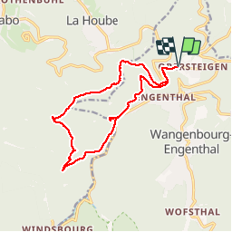
Ruta Senderismo de 14,3 km a descubrir en Gran Este, Bajo-Rin, Wangenbourg-Engenthal. Esta ruta ha sido propuesta por oscar1.
Descripción
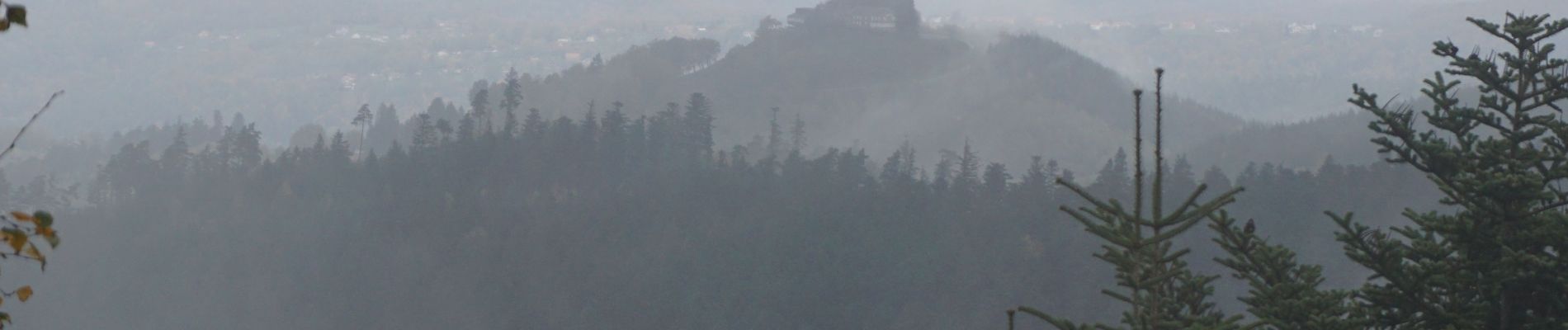
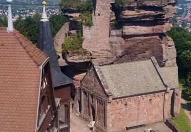
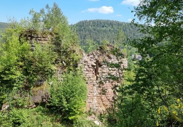
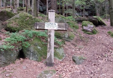
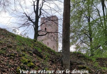
Belles ballades . A découvrir la fontaine Goldbrunnen, La Grotte du Rosskopf, divers Rochers et notamment le Backofenfelsen d'où on a une magnifique vue sur le rocher du Dabo.
Localización
País:
France
Región :
Gran Este
Departamento/provincia :
Bajo-Rin
Municipio :
Wangenbourg-Engenthal
Localidad:
Unknown
Salida:(Dec)
Salida:(UTM)
375006 ; 5389025 (32U) N.
Comentarios
Excursiones cerca
![Excursión Senderismo Reinhardsmunster - 2021-09-01 Marche Reinhardsmunster Haut Barr - Photo](https://media.geolcdn.com/t/375/260/266b2ac9-dd10-4dc7-a762-c9d36720cc88.jpg&format=jpg&maxdim=2)
![Senderismo Senderismo](https://static1.geolcdn.com/sitytour/trail-icons/101.png)
2021-09-01 Marche Reinhardsmunster Haut Barr
Senderismo
Muy difícil
Reinhardsmunster,
Gran Este,
Bajo-Rin,
France
![](/images/other/stat-length.png)
21 km | 32 km-effort
6h 39min
![](https://static1.geolcdn.com/siteimages/upload/files/16400158638029165_repeat_loop_refresh_sync_direction_icon.png)
Sí
![Excursión Senderismo Reinhardsmunster - 2020-06-13 Marche Ditschelkopf Schweizerberg - Photo](https://media.geolcdn.com/t/375/260/d6670ae9-2bf3-459d-a4b8-1c117627d287.jpg&format=jpg&maxdim=2)
![Senderismo Senderismo](https://static1.geolcdn.com/sitytour/trail-icons/101.png)
2020-06-13 Marche Ditschelkopf Schweizerberg
Senderismo
Muy fácil
Reinhardsmunster,
Gran Este,
Bajo-Rin,
France
![](/images/other/stat-length.png)
14,5 km | 22 km-effort
4h 52min
![](https://static1.geolcdn.com/siteimages/upload/files/16400158638029165_repeat_loop_refresh_sync_direction_icon.png)
Sí
![Excursión Senderismo Wangenbourg-Engenthal - 2020-03-14 Marche Engenthal le bas - Photo](https://media.geolcdn.com/t/375/260/ba70735c-7023-4458-a456-f43a6f2e7606.jpg&format=jpg&maxdim=2)
![Senderismo Senderismo](https://static1.geolcdn.com/sitytour/trail-icons/101.png)
2020-03-14 Marche Engenthal le bas
Senderismo
Muy fácil
Wangenbourg-Engenthal,
Gran Este,
Bajo-Rin,
France
![](/images/other/stat-length.png)
14,3 km | 22 km-effort
4h 27min
![](https://static1.geolcdn.com/siteimages/upload/files/16400158638029165_repeat_loop_refresh_sync_direction_icon.png)
Sí
![Excursión Senderismo Wangenbourg-Engenthal - 2019-11-16 Marche Wangenbourg Castelberg - Photo](https://media.geolcdn.com/t/375/260/5fe565fb-6e88-4bed-a889-a75a33bb061a.jpg&format=jpg&maxdim=2)
![Senderismo Senderismo](https://static1.geolcdn.com/sitytour/trail-icons/101.png)
2019-11-16 Marche Wangenbourg Castelberg
Senderismo
Muy fácil
Wangenbourg-Engenthal,
Gran Este,
Bajo-Rin,
France
![](/images/other/stat-length.png)
19,8 km | 31 km-effort
4h 51min
![](https://static1.geolcdn.com/siteimages/upload/files/16400158638029165_repeat_loop_refresh_sync_direction_icon.png)
Sí
![Excursión Senderismo Wangenbourg-Engenthal - 2017-02-24 Marche Schneeberg - Photo](https://media.geolcdn.com/t/375/260/ext.jpg?maxdim=2&url=https%3A%2F%2Fstatic1.geolcdn.com%2Fsiteimages%2Fupload%2Ffiles%2F1553511878bg_sport_marche.png)
![Senderismo Senderismo](https://static1.geolcdn.com/sitytour/trail-icons/101.png)
2017-02-24 Marche Schneeberg
Senderismo
Muy fácil
(1)
Wangenbourg-Engenthal,
Gran Este,
Bajo-Rin,
France
![](/images/other/stat-length.png)
12,8 km | 19,9 km-effort
Desconocido
![](https://static1.geolcdn.com/siteimages/upload/files/16400158638029165_repeat_loop_refresh_sync_direction_icon.png)
Sí
![Excursión Senderismo Wangenbourg-Engenthal - obersteigen - Photo](https://media.geolcdn.com/t/375/260/1627429b-7fff-427f-af0e-c37d2da3b0ec.jpg&format=jpg&maxdim=2)
![Senderismo Senderismo](https://static1.geolcdn.com/sitytour/trail-icons/101.png)
obersteigen
Senderismo
Difícil
Wangenbourg-Engenthal,
Gran Este,
Bajo-Rin,
France
![](/images/other/stat-length.png)
44 km | 59 km-effort
5h 56min
![](https://static1.geolcdn.com/siteimages/upload/files/16400158638029165_repeat_loop_refresh_sync_direction_icon.png)
No
![Excursión Senderismo Wangenbourg-Engenthal - ARCA WANGENBOURG - Photo](https://media.geolcdn.com/t/375/260/8387777e-0af4-46e8-976a-a6425ad883f8.jpg&format=jpg&maxdim=2)
![Senderismo Senderismo](https://static1.geolcdn.com/sitytour/trail-icons/101.png)
ARCA WANGENBOURG
Senderismo
Medio
Wangenbourg-Engenthal,
Gran Este,
Bajo-Rin,
France
![](/images/other/stat-length.png)
13,2 km | 19 km-effort
4h 19min
![](https://static1.geolcdn.com/siteimages/upload/files/16400158638029165_repeat_loop_refresh_sync_direction_icon.png)
Sí
![Excursión Senderismo Dabo - Windsbourg Dabo - Photo](https://media.geolcdn.com/t/375/260/849eb1af-57e5-4b6a-92a2-d1e4a3c0d38f.jpg&format=jpg&maxdim=2)
![Senderismo Senderismo](https://static1.geolcdn.com/sitytour/trail-icons/101.png)
Windsbourg Dabo
Senderismo
Fácil
Dabo,
Gran Este,
Mosela,
France
![](/images/other/stat-length.png)
14,3 km | 19,7 km-effort
3h 6min
![](https://static1.geolcdn.com/siteimages/upload/files/16400158638029165_repeat_loop_refresh_sync_direction_icon.png)
Sí
![Excursión Senderismo Wangenbourg-Engenthal - 2023-04-28_17h34m45_2023-04-26_10-35(2) - Photo](https://media.geolcdn.com/t/375/260/ee107caa-b5bb-4c13-b62b-5f4288972d90.jpg&format=jpg&maxdim=2)
![Senderismo Senderismo](https://static1.geolcdn.com/sitytour/trail-icons/101.png)
2023-04-28_17h34m45_2023-04-26_10-35(2)
Senderismo
Medio
(1)
Wangenbourg-Engenthal,
Gran Este,
Bajo-Rin,
France
![](/images/other/stat-length.png)
14,1 km | 22 km-effort
4h 56min
![](https://static1.geolcdn.com/siteimages/upload/files/16400158638029165_repeat_loop_refresh_sync_direction_icon.png)
Sí