![](/images/other/stat-length.png)
![Excursión Paseo ecuestre Notre-Dame-de-Monts - Plage et forêt de Notre Dame de Monts - Photo](https://media.geolcdn.com/t/1900/400/87aed5f8-8e67-4bc3-b768-ef861db550ce.jpg&format=pjpeg&maxdim=2)
Plage et forêt de Notre Dame de Monts
Gilles85
Usuario
![Longitud](/images/other/stat-length.png)
![Altitud máxima](https://static1.geolcdn.com/siteimages/upload/files/1508320355ic_sort_altitude_max_24dp.png)
![Desnivel positivo](https://static1.geolcdn.com/siteimages/upload/files/1508320355ic_sort_den_pos_24dp.png)
![Km-Effort](/images/other/stat-length.png)
![Altitud mínima](https://static1.geolcdn.com/siteimages/upload/files/1508320355ic_sort_altitude_min_24dp.png)
![Desnivel negativo](https://static1.geolcdn.com/siteimages/upload/files/1508320355ic_sort_den_neg_24dp.png)
![Boucle](https://static1.geolcdn.com/siteimages/upload/files/16400158638029165_repeat_loop_refresh_sync_direction_icon.png)
![Paseo ecuestre](https://static1.geolcdn.com/sitytour/trail-icons/301.png)
2h35
Dificultad : Fácil
![Escanee este código QR para abrir la excursión en la aplicación SityTrail](https://capi.geolives.com/qq0zvz2zws4bq2lad0pu/sitytour/trails/2253820/qr.png?size=200)
Aplicación GPS de excursión GRATIS
A propósito
Ruta Paseo ecuestre de 20 km a descubrir en Países del Loira, Vandea, Notre-Dame-de-Monts. Esta ruta ha sido propuesta por Gilles85.
Descripción
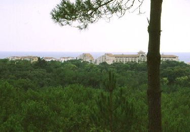
Le départ se fait à La Parée Grollier. Une aire est aménagée pour recevoir les chevaux( barres d'attache et même un paddock). A partir de là, suivre le sentier équestre bien balisé par l'ONF ( panneau avec une tête de cheval verte). Ne pas sortir de ce sentier sous peine d'amande.
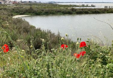
La boucle peut se faire dans les 2 sens. pour rejoindre la forêt de la plage, repérez vous avec votre sitytrail, les panneaux ONF sont peu visibles de loin, mais il y en a à l'entrée du sentier. Bonne promenade
Localización
Comentarios
Excursiones cerca
![Excursión Bici de montaña Barbâtre - Ile de Noirmoutier - Photo](https://media.geolcdn.com/t/375/260/ext.jpg?maxdim=2&url=https%3A%2F%2Fservices.sitytrail.com%2FGeolivesWS%2FDownloadMedia.ashx%3FTrailID%3D100765%26Media%3D275_6.jpg)
![Bici de montaña Bici de montaña](https://static1.geolcdn.com/sitytour/trail-icons/202.png)
Bici de montaña
![](/images/other/stat-length.png)
![](https://static1.geolcdn.com/siteimages/upload/files/16400158638029165_repeat_loop_refresh_sync_direction_icon.png)
![Excursión Bicicleta híbrida La Barre-de-Monts - La Barre-de-Monts-Boucle du Daviaud - Photo](https://media.geolcdn.com/t/375/260/f7185e7c-5ab5-482f-bfdb-40b3b1459f78.jpg&format=jpg&maxdim=2)
![Bicicleta híbrida Bicicleta híbrida](https://static1.geolcdn.com/sitytour/trail-icons/203.png)
Bicicleta híbrida
![](/images/other/stat-length.png)
![](https://static1.geolcdn.com/siteimages/upload/files/16400158638029165_repeat_loop_refresh_sync_direction_icon.png)
![Excursión Senderismo La Barre-de-Monts - ostréiculteurs - Photo](https://media.geolcdn.com/t/375/260/072a44b0-c952-4e8b-9f56-93c4ce319af4.jpg&format=jpg&maxdim=2)
![Senderismo Senderismo](https://static1.geolcdn.com/sitytour/trail-icons/101.png)
Senderismo
![](/images/other/stat-length.png)
![](https://static1.geolcdn.com/siteimages/upload/files/16400158638029165_repeat_loop_refresh_sync_direction_icon.png)
![Excursión Senderismo Barbâtre - le pont, moulin des yuccas, le gois, le pont de Noirmoutier - Photo](https://media.geolcdn.com/t/375/260/ext.jpg?maxdim=2&url=https%3A%2F%2Fservices.sitytrail.com%2FGeolivesWS%2FDownloadMedia.ashx%3FTrailID%3D153890%26Media%3D20120916132328.jpg)
![Senderismo Senderismo](https://static1.geolcdn.com/sitytour/trail-icons/101.png)
Senderismo
![](/images/other/stat-length.png)
![](https://static1.geolcdn.com/siteimages/upload/files/16400158638029165_repeat_loop_refresh_sync_direction_icon.png)
![Excursión Patinaje Barbâtre - Ile de Noirmoutier - Photo](https://media.geolcdn.com/t/375/260/ext.jpg?maxdim=2&url=https%3A%2F%2Fservices.sitytrail.com%2FGeolivesWS%2FDownloadMedia.ashx%3FTrailID%3D100766%26Media%3D275_3.jpg)
![Patinaje Patinaje](https://static1.geolcdn.com/sitytour/trail-icons/901.png)
Patinaje
![](/images/other/stat-length.png)
![](https://static1.geolcdn.com/siteimages/upload/files/16400158638029165_repeat_loop_refresh_sync_direction_icon.png)
![Excursión Senderismo Notre-Dame-de-Monts - ND HYPODROME - Photo](https://media.geolcdn.com/t/375/260/ext.jpg?maxdim=2&url=https%3A%2F%2Fstatic1.geolcdn.com%2Fsiteimages%2Fupload%2Ffiles%2F1553511878bg_sport_marche.png)
![Senderismo Senderismo](https://static1.geolcdn.com/sitytour/trail-icons/101.png)
Senderismo
![](/images/other/stat-length.png)
![](https://static1.geolcdn.com/siteimages/upload/files/16400158638029165_repeat_loop_refresh_sync_direction_icon.png)
![Excursión Senderismo La Barre-de-Monts - Fromentine - Photo](https://media.geolcdn.com/t/375/260/8e53e7f5-6db2-45d9-8c0c-82e686135ce0.jpg&format=jpg&maxdim=2)
![Senderismo Senderismo](https://static1.geolcdn.com/sitytour/trail-icons/101.png)
Senderismo
![](/images/other/stat-length.png)
![](https://static1.geolcdn.com/siteimages/upload/files/16400158638029165_repeat_loop_refresh_sync_direction_icon.png)
![Excursión Senderismo La Barre-de-Monts - Le phare - Photo](https://media.geolcdn.com/t/375/260/7a62d1a4-1739-4153-ae0a-3f1795228efe.jpg&format=jpg&maxdim=2)
![Senderismo Senderismo](https://static1.geolcdn.com/sitytour/trail-icons/101.png)
Senderismo
![](/images/other/stat-length.png)
![](https://static1.geolcdn.com/siteimages/upload/files/16400158638029165_repeat_loop_refresh_sync_direction_icon.png)
![Excursión Senderismo Notre-Dame-de-Monts - Notre-Dame-de-Monts-Découverte forêt et dunes - Photo](https://media.geolcdn.com/t/375/260/66f2e4a7-2bf0-480f-9186-d02c79d779de.jpg&format=jpg&maxdim=2)
![Senderismo Senderismo](https://static1.geolcdn.com/sitytour/trail-icons/101.png)
Senderismo
![](/images/other/stat-length.png)
![](https://static1.geolcdn.com/siteimages/upload/files/16400158638029165_repeat_loop_refresh_sync_direction_icon.png)