![](/images/other/stat-length.png)
![Excursión Senderismo Saint-Germain-d'Aunay - 2019-10-25 St Germain d'Aunay - Photo](https://media.geolcdn.com/t/1900/400/ext.pjpeg?maxdim=2&url=https%3A%2F%2Fstatic1.geolcdn.com%2Fsiteimages%2Fupload%2Ffiles%2F1553511878bg_sport_marche.png)
2019-10-25 St Germain d'Aunay
BPinglier
Usuario
![Longitud](/images/other/stat-length.png)
Longitud
9,3 km
![Altitud máxima](https://static1.geolcdn.com/siteimages/upload/files/1508320355ic_sort_altitude_max_24dp.png)
Altitud máxima
232 m
![Desnivel positivo](https://static1.geolcdn.com/siteimages/upload/files/1508320355ic_sort_den_pos_24dp.png)
Desnivel positivo
121 m
![Km-Effort](/images/other/stat-length.png)
Km-Effort
10,9 km
![Altitud mínima](https://static1.geolcdn.com/siteimages/upload/files/1508320355ic_sort_altitude_min_24dp.png)
Altitud mínima
186 m
![Desnivel negativo](https://static1.geolcdn.com/siteimages/upload/files/1508320355ic_sort_den_neg_24dp.png)
Desnivel negativo
123 m
![Boucle](https://static1.geolcdn.com/siteimages/upload/files/16400158638029165_repeat_loop_refresh_sync_direction_icon.png)
Boucle
Sí
Fecha de creación :
2019-10-25 14:28:53.796
Última modificación :
2019-10-25 17:19:55.246
![Senderismo](https://static1.geolcdn.com/sitytour/trail-icons/101.png)
2h06
Dificultad : Muy fácil
![Escanee este código QR para abrir la excursión en la aplicación SityTrail](https://capi.geolives.com/qq0zvz2zws4bq2lad0pu/sitytour/trails/2249673/qr.png?size=200)
Aplicación GPS de excursión GRATIS
A propósito
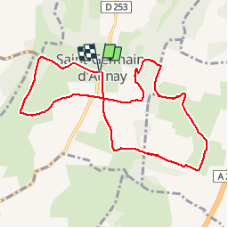
Ruta Senderismo de 9,3 km a descubrir en Normandía, Orne, Saint-Germain-d'Aunay. Esta ruta ha sido propuesta por BPinglier.
Descripción
Randonnée facile et assez ombragée sur chemins généralement non balisés. Quelques portions de route goudronnée peu fréquentée. Prévoir de bonnes chaussures.
Parking possible près du monument aux morts.
Localización
País:
France
Región :
Normandía
Departamento/provincia :
Orne
Municipio :
Saint-Germain-d'Aunay
Localidad:
Unknown
Salida:(Dec)
Salida:(UTM)
307972 ; 5422392 (31U) N.
Comentarios
Excursiones cerca
![Excursión Senderismo Sap-en-Auge - Le Sap - Photo](https://media.geolcdn.com/t/375/260/ext.jpg?maxdim=2&url=https%3A%2F%2Fstatic1.geolcdn.com%2Fsiteimages%2Fupload%2Ffiles%2F1553511878bg_sport_marche.png)
![Senderismo Senderismo](https://static1.geolcdn.com/sitytour/trail-icons/101.png)
Le Sap
Senderismo
Muy fácil
(1)
Sap-en-Auge,
Normandía,
Orne,
France
![](/images/other/stat-length.png)
13,5 km | 15,1 km-effort
3h 20min
![](https://static1.geolcdn.com/siteimages/upload/files/16400158638029165_repeat_loop_refresh_sync_direction_icon.png)
Sí
![Excursión Senderismo La Goulafrière - Circuit de la Grande Vallée - La Goulafrière - Photo](https://media.geolcdn.com/t/375/260/ext.jpg?maxdim=2&url=https%3A%2F%2Fservices.sitytrail.com%2FGeolivesWS%2FDownloadMedia.ashx%3FTrailID%3D110461%26Media%3D5968_1.jpg)
![Senderismo Senderismo](https://static1.geolcdn.com/sitytour/trail-icons/101.png)
Circuit de la Grande Vallée - La Goulafrière
Senderismo
Medio
La Goulafrière,
Normandía,
Eure,
France
![](/images/other/stat-length.png)
11,2 km | 13,1 km-effort
2h 45min
![](https://static1.geolcdn.com/siteimages/upload/files/16400158638029165_repeat_loop_refresh_sync_direction_icon.png)
Sí
![Excursión Senderismo La Goulafrière - La Goulafriere 27 - Photo](https://media.geolcdn.com/t/375/260/57bcf86c-5668-45d7-9473-13e9f837b6a9.jpg&format=jpg&maxdim=2)
![Senderismo Senderismo](https://static1.geolcdn.com/sitytour/trail-icons/101.png)
La Goulafriere 27
Senderismo
Fácil
La Goulafrière,
Normandía,
Eure,
France
![](/images/other/stat-length.png)
11,9 km | 13,9 km-effort
3h 8min
![](https://static1.geolcdn.com/siteimages/upload/files/16400158638029165_repeat_loop_refresh_sync_direction_icon.png)
Sí
![Excursión Senderismo Sap-en-Auge - Le sap - Photo](https://media.geolcdn.com/t/375/260/ext.jpg?maxdim=2&url=https%3A%2F%2Fstatic1.geolcdn.com%2Fsiteimages%2Fupload%2Ffiles%2F1553511878bg_sport_marche.png)
![Senderismo Senderismo](https://static1.geolcdn.com/sitytour/trail-icons/101.png)
![Excursión Carrera La Ferté-en-Ouche - run - Photo](https://media.geolcdn.com/t/375/260/ext.jpg?maxdim=2&url=https%3A%2F%2Fstatic1.geolcdn.com%2Fsiteimages%2Fupload%2Ffiles%2F1524743154running.jpg)
![Carrera Carrera](https://static1.geolcdn.com/sitytour/trail-icons/103.png)
![Excursión Moto La Ferté-en-Ouche - vever - Photo](https://media.geolcdn.com/t/375/260/ext.jpg?maxdim=2&url=https%3A%2F%2Fstatic1.geolcdn.com%2Fsiteimages%2Fupload%2Ffiles%2F1524743155moto.jpg)
![Moto Moto](https://static1.geolcdn.com/sitytour/trail-icons/402.png)
![Excursión Senderismo La Ferté-en-Ouche - monnai - Photo](https://media.geolcdn.com/t/375/260/ext.jpg?maxdim=2&url=https%3A%2F%2Fstatic1.geolcdn.com%2Fsiteimages%2Fupload%2Ffiles%2F1553511878bg_sport_marche.png)
![Senderismo Senderismo](https://static1.geolcdn.com/sitytour/trail-icons/101.png)
monnai
Senderismo
Difícil
La Ferté-en-Ouche,
Normandía,
Orne,
France
![](/images/other/stat-length.png)
13,2 km | 14,6 km-effort
2h 40min
![](https://static1.geolcdn.com/siteimages/upload/files/16400158638029165_repeat_loop_refresh_sync_direction_icon.png)
Sí
![Excursión Moto La Ferté-en-Ouche - Simon Yannick - Photo](https://media.geolcdn.com/t/375/260/ext.jpg?maxdim=2&url=https%3A%2F%2Fstatic1.geolcdn.com%2Fsiteimages%2Fupload%2Ffiles%2F1524743155moto.jpg)
![Moto Moto](https://static1.geolcdn.com/sitytour/trail-icons/402.png)
Simon Yannick
Moto
Muy fácil
La Ferté-en-Ouche,
Normandía,
Orne,
France
![](/images/other/stat-length.png)
18,6 km | 22 km-effort
54min
![](https://static1.geolcdn.com/siteimages/upload/files/16400158638029165_repeat_loop_refresh_sync_direction_icon.png)
No
![Excursión Moto La Ferté-en-Ouche - Le valet /vimoutiers - Photo](https://media.geolcdn.com/t/375/260/ext.jpg?maxdim=2&url=https%3A%2F%2Fstatic1.geolcdn.com%2Fsiteimages%2Fupload%2Ffiles%2F1524743155moto.jpg)
![Moto Moto](https://static1.geolcdn.com/sitytour/trail-icons/402.png)
Le valet /vimoutiers
Moto
Fácil
La Ferté-en-Ouche,
Normandía,
Orne,
France
![](/images/other/stat-length.png)
50 km | 59 km-effort
1h 55min
![](https://static1.geolcdn.com/siteimages/upload/files/16400158638029165_repeat_loop_refresh_sync_direction_icon.png)
No