![](/images/other/stat-length.png)
![Excursión Cicloturismo Lavars - RPT050 - Photo](https://media.geolcdn.com/t/1900/400/ext.pjpeg?maxdim=2&url=https%3A%2F%2Fstatic1.geolcdn.com%2Fsiteimages%2Fupload%2Ffiles%2F1524743154velo.jpg)
RPT050
biollay
Usuario
![Longitud](/images/other/stat-length.png)
Longitud
32 km
![Altitud máxima](https://static1.geolcdn.com/siteimages/upload/files/1508320355ic_sort_altitude_max_24dp.png)
Altitud máxima
895 m
![Desnivel positivo](https://static1.geolcdn.com/siteimages/upload/files/1508320355ic_sort_den_pos_24dp.png)
Desnivel positivo
651 m
![Km-Effort](/images/other/stat-length.png)
Km-Effort
40 km
![Altitud mínima](https://static1.geolcdn.com/siteimages/upload/files/1508320355ic_sort_altitude_min_24dp.png)
Altitud mínima
587 m
![Desnivel negativo](https://static1.geolcdn.com/siteimages/upload/files/1508320355ic_sort_den_neg_24dp.png)
Desnivel negativo
651 m
![Boucle](https://static1.geolcdn.com/siteimages/upload/files/16400158638029165_repeat_loop_refresh_sync_direction_icon.png)
Boucle
Sí
Fecha de creación :
2019-10-21 13:13:02.218
Última modificación :
2019-10-21 13:27:25.064
![Cicloturismo](https://static1.geolcdn.com/sitytour/trail-icons/204.png)
1h30
Dificultad : Muy fácil
![Escanee este código QR para abrir la excursión en la aplicación SityTrail](https://capi.geolives.com/qq0zvz2zws4bq2lad0pu/sitytour/trails/2243866/qr.png?size=200)
Aplicación GPS de excursión GRATIS
A propósito
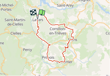
Ruta Cicloturismo de 32 km a descubrir en Auvergne-Rhône-Alpes, Isère, Lavars. Esta ruta ha sido propuesta por biollay.
Descripción
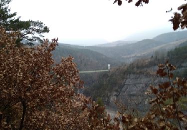
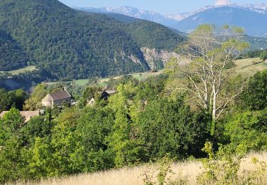
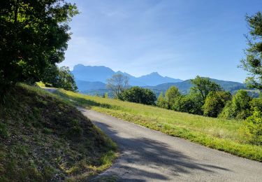
Lavars, Prébois, Col Accarias, Col de Cornillon : des points de vue splendides sur le Trièves concentrés en un circuit pour en prendre plein les yeux !
Localización
País:
France
Región :
Auvergne-Rhône-Alpes
Departamento/provincia :
Isère
Municipio :
Lavars
Localidad:
Unknown
Salida:(Dec)
Salida:(UTM)
711147 ; 4969684 (31T) N.
Comentarios
Excursiones cerca
![Excursión Senderismo Mayres-Savel - Passerelles Du Drac Et de L'Ebron - Photo](https://media.geolcdn.com/t/375/260/f4846bf3-414e-4c51-a6cb-c2da9b823649.jpg&format=jpg&maxdim=2)
![Senderismo Senderismo](https://static1.geolcdn.com/sitytour/trail-icons/101.png)
Passerelles Du Drac Et de L'Ebron
Senderismo
Fácil
Mayres-Savel,
Auvergne-Rhône-Alpes,
Isère,
France
![](/images/other/stat-length.png)
12,2 km | 18,4 km-effort
3h 13min
![](https://static1.geolcdn.com/siteimages/upload/files/16400158638029165_repeat_loop_refresh_sync_direction_icon.png)
No
![Excursión Caballo Roissard - Trieves - Devoluy - Photo](https://media.geolcdn.com/t/375/260/532091fd-ff63-40b6-9790-4b260fef3e51.jpg&format=jpg&maxdim=2)
![Caballo Caballo](https://static1.geolcdn.com/sitytour/trail-icons/300.png)
Trieves - Devoluy
Caballo
Difícil
Roissard,
Auvergne-Rhône-Alpes,
Isère,
France
![](/images/other/stat-length.png)
131 km | 200 km-effort
Desconocido
![](https://static1.geolcdn.com/siteimages/upload/files/16400158638029165_repeat_loop_refresh_sync_direction_icon.png)
Sí
![Excursión Senderismo Mayres-Savel - Passerelles Hymalayene Mayres + 250 - Photo](https://media.geolcdn.com/t/375/260/e79ec6b2-c62a-43e0-95ca-91baa034bf5d.jpg&format=jpg&maxdim=2)
![Senderismo Senderismo](https://static1.geolcdn.com/sitytour/trail-icons/101.png)
Passerelles Hymalayene Mayres + 250
Senderismo
Medio
Mayres-Savel,
Auvergne-Rhône-Alpes,
Isère,
France
![](/images/other/stat-length.png)
4,9 km | 8,2 km-effort
1h 59min
![](https://static1.geolcdn.com/siteimages/upload/files/16400158638029165_repeat_loop_refresh_sync_direction_icon.png)
Sí
![Excursión Senderismo Mayres-Savel - Randonnée des passerelles - Photo](https://media.geolcdn.com/t/375/260/f81885ad-9d99-466e-990d-175fbd3a925e.jpg&format=jpg&maxdim=2)
![Senderismo Senderismo](https://static1.geolcdn.com/sitytour/trail-icons/101.png)
Randonnée des passerelles
Senderismo
Fácil
Mayres-Savel,
Auvergne-Rhône-Alpes,
Isère,
France
![](/images/other/stat-length.png)
11,9 km | 17,9 km-effort
4h 51min
![](https://static1.geolcdn.com/siteimages/upload/files/16400158638029165_repeat_loop_refresh_sync_direction_icon.png)
No
![Excursión Senderismo Treffort - Les deux passerelles Drac et Ebron - Photo](https://media.geolcdn.com/t/375/260/3778f66d-36c2-41c5-9e06-64b09fbd2374.jpg&format=jpg&maxdim=2)
![Senderismo Senderismo](https://static1.geolcdn.com/sitytour/trail-icons/101.png)
Les deux passerelles Drac et Ebron
Senderismo
Medio
Treffort,
Auvergne-Rhône-Alpes,
Isère,
France
![](/images/other/stat-length.png)
15,8 km | 25 km-effort
3h 23min
![](https://static1.geolcdn.com/siteimages/upload/files/16400158638029165_repeat_loop_refresh_sync_direction_icon.png)
Sí
![Excursión Senderismo Lavars - Serre de la Fayolle - Photo](https://media.geolcdn.com/t/375/260/95bdaed1-9210-48db-8488-a02aafbf5b89.jpg&format=jpg&maxdim=2)
![Senderismo Senderismo](https://static1.geolcdn.com/sitytour/trail-icons/101.png)
Serre de la Fayolle
Senderismo
Medio
Lavars,
Auvergne-Rhône-Alpes,
Isère,
France
![](/images/other/stat-length.png)
13,3 km | 19,9 km-effort
5h 53min
![](https://static1.geolcdn.com/siteimages/upload/files/16400158638029165_repeat_loop_refresh_sync_direction_icon.png)
Sí
![Excursión Senderismo Treffort - passerelles hymalayennes - Photo](https://media.geolcdn.com/t/375/260/ext.jpg?maxdim=2&url=https%3A%2F%2Fservices.sitytrail.com%2FGeolivesWS%2FDownloadMedia.ashx%3FTrailID%3D912891%26Media%3Dfix__20180225112057.jpg)
![Senderismo Senderismo](https://static1.geolcdn.com/sitytour/trail-icons/101.png)
passerelles hymalayennes
Senderismo
Fácil
Treffort,
Auvergne-Rhône-Alpes,
Isère,
France
![](/images/other/stat-length.png)
15,4 km | 25 km-effort
4h 25min
![](https://static1.geolcdn.com/siteimages/upload/files/16400158638029165_repeat_loop_refresh_sync_direction_icon.png)
No
![Excursión Senderismo Mayres-Savel - Mayres..La Beauté 250 + - Photo](https://media.geolcdn.com/t/375/260/5e3a451e-b45b-433c-9f01-b5cf056dd88f.jpg&format=jpg&maxdim=2)
![Senderismo Senderismo](https://static1.geolcdn.com/sitytour/trail-icons/101.png)
Mayres..La Beauté 250 +
Senderismo
Medio
Mayres-Savel,
Auvergne-Rhône-Alpes,
Isère,
France
![](/images/other/stat-length.png)
8,3 km | 11,6 km-effort
2h 55min
![](https://static1.geolcdn.com/siteimages/upload/files/16400158638029165_repeat_loop_refresh_sync_direction_icon.png)
Sí
![Excursión Senderismo Mayres-Savel - Mayres..St Arey 70 + - Photo](https://media.geolcdn.com/t/375/260/f86ad6e4-2bf6-4563-97dd-aeb39fddb9b1.jpg&format=jpg&maxdim=2)
![Senderismo Senderismo](https://static1.geolcdn.com/sitytour/trail-icons/101.png)
Mayres..St Arey 70 +
Senderismo
Fácil
Mayres-Savel,
Auvergne-Rhône-Alpes,
Isère,
France
![](/images/other/stat-length.png)
4,2 km | 5,3 km-effort
1h 13min
![](https://static1.geolcdn.com/siteimages/upload/files/16400158638029165_repeat_loop_refresh_sync_direction_icon.png)
Sí