![](/images/other/stat-length.png)
![Excursión Otra actividad Lauterbrunnen - Isenflue-Baellenhoechst-Saxeten - Photo](https://media.geolcdn.com/t/1900/400/ext.pjpeg?maxdim=2&url=https%3A%2F%2Fstatic1.geolcdn.com%2Fsiteimages%2Fupload%2Ffiles%2F1545311037marcheuse_200dpi.jpg)
Isenflue-Baellenhoechst-Saxeten
U106659
Usuario
![Longitud](/images/other/stat-length.png)
Longitud
13,4 km
![Altitud máxima](https://static1.geolcdn.com/siteimages/upload/files/1508320355ic_sort_altitude_max_24dp.png)
Altitud máxima
2097 m
![Desnivel positivo](https://static1.geolcdn.com/siteimages/upload/files/1508320355ic_sort_den_pos_24dp.png)
Desnivel positivo
734 m
![Km-Effort](/images/other/stat-length.png)
Km-Effort
25 km
![Altitud mínima](https://static1.geolcdn.com/siteimages/upload/files/1508320355ic_sort_altitude_min_24dp.png)
Altitud mínima
1111 m
![Desnivel negativo](https://static1.geolcdn.com/siteimages/upload/files/1508320355ic_sort_den_neg_24dp.png)
Desnivel negativo
1140 m
![Boucle](https://static1.geolcdn.com/siteimages/upload/files/16400158638029165_repeat_loop_refresh_sync_direction_icon.png)
Boucle
No
Fecha de creación :
2014-12-11 00:00:00.0
Última modificación :
2014-12-11 00:00:00.0
![Otra actividad](https://static1.geolcdn.com/sitytour/trail-icons/900.png)
--
Dificultad : Desconocido
![Escanee este código QR para abrir la excursión en la aplicación SityTrail](https://capi.geolives.com/qq0zvz2zws4bq2lad0pu/sitytour/trails/22424/qr.png?size=200)
Aplicación GPS de excursión GRATIS
A propósito
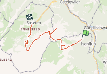
Ruta Otra actividad de 13,4 km a descubrir en Berna, Verwaltungskreis Interlaken-Oberhasli, Lauterbrunnen. Esta ruta ha sido propuesta por U106659.
Descripción
Herbstliche Wanderung mit einem moderaten Aufstieg und einem wunderschönen Aussichtspunkt auf dem Bällenhöchst
Localización
País:
Switzerland
Región :
Berna
Departamento/provincia :
Verwaltungskreis Interlaken-Oberhasli
Municipio :
Lauterbrunnen
Localidad:
Unknown
Salida:(Dec)
Salida:(UTM)
414897 ; 5163908 (32T) N.
Comentarios
Excursiones cerca
![Excursión A pie Lauterbrunnen - CH-Grütschalp - Isenfluh - Photo](https://media.geolcdn.com/t/375/260/28be3b43-f3ac-42df-9f0c-340c3e14dd2e.jpeg&format=jpg&maxdim=2)
![A pie A pie](https://static1.geolcdn.com/sitytour/trail-icons/100.png)
CH-Grütschalp - Isenfluh
A pie
Fácil
Lauterbrunnen,
Berna,
Verwaltungskreis Interlaken-Oberhasli,
Switzerland
![](/images/other/stat-length.png)
4,2 km | 6 km-effort
1h 21min
![](https://static1.geolcdn.com/siteimages/upload/files/16400158638029165_repeat_loop_refresh_sync_direction_icon.png)
No
![Excursión A pie Lauterbrunnen - CH-Isenfluh - Alpweg - Photo](https://media.geolcdn.com/t/375/260/47546b31-1560-4321-a252-3e6f8645f75e.jpeg&format=jpg&maxdim=2)
![A pie A pie](https://static1.geolcdn.com/sitytour/trail-icons/100.png)
CH-Isenfluh - Alpweg
A pie
Fácil
Lauterbrunnen,
Berna,
Verwaltungskreis Interlaken-Oberhasli,
Switzerland
![](/images/other/stat-length.png)
4,5 km | 7,5 km-effort
1h 42min
![](https://static1.geolcdn.com/siteimages/upload/files/16400158638029165_repeat_loop_refresh_sync_direction_icon.png)
No
![Excursión A pie Lauterbrunnen - Sousegg - Sattel - Photo](https://media.geolcdn.com/t/375/260/5a3fcfc2-bf24-445e-abb4-4eb6a5887c5e.jpeg&format=jpg&maxdim=2)
![A pie A pie](https://static1.geolcdn.com/sitytour/trail-icons/100.png)
Sousegg - Sattel
A pie
Fácil
Lauterbrunnen,
Berna,
Verwaltungskreis Interlaken-Oberhasli,
Switzerland
![](/images/other/stat-length.png)
4,2 km | 10,9 km-effort
2h 29min
![](https://static1.geolcdn.com/siteimages/upload/files/16400158638029165_repeat_loop_refresh_sync_direction_icon.png)
No
![Excursión A pie Lauterbrunnen - CH-Pletschenalp-Höhlücke - Photo](https://media.geolcdn.com/t/375/260/28be3b43-f3ac-42df-9f0c-340c3e14dd2e.jpeg&format=jpg&maxdim=2)
![A pie A pie](https://static1.geolcdn.com/sitytour/trail-icons/100.png)
CH-Pletschenalp-Höhlücke
A pie
Fácil
Lauterbrunnen,
Berna,
Verwaltungskreis Interlaken-Oberhasli,
Switzerland
![](/images/other/stat-length.png)
3,4 km | 5,2 km-effort
1h 10min
![](https://static1.geolcdn.com/siteimages/upload/files/16400158638029165_repeat_loop_refresh_sync_direction_icon.png)
No
![Excursión Senderismo Gündlischwand - Schynige Platte chemin panoramique 06.07.15 - Photo](https://media.geolcdn.com/t/375/260/ext.jpg?maxdim=2&url=https%3A%2F%2Fservices.sitytrail.com%2FGeolivesWS%2FDownloadMedia.ashx%3FTrailID%3D441975%26Media%3Da208e773-71ba-44ed-a8d6-0cbc898752b8.jpg)
![Senderismo Senderismo](https://static1.geolcdn.com/sitytour/trail-icons/101.png)
Schynige Platte chemin panoramique 06.07.15
Senderismo
Medio
Gündlischwand,
Berna,
Verwaltungskreis Interlaken-Oberhasli,
Switzerland
![](/images/other/stat-length.png)
7,4 km | 11,7 km-effort
3h 0min
![](https://static1.geolcdn.com/siteimages/upload/files/16400158638029165_repeat_loop_refresh_sync_direction_icon.png)
Sí
![Excursión Otra actividad Lauterbrunnen - ViaRegio_Jungfrau_5 - Photo](https://media.geolcdn.com/t/375/260/ext.jpg?maxdim=2&url=https%3A%2F%2Fstatic1.geolcdn.com%2Fsiteimages%2Fupload%2Ffiles%2F1545311037marcheuse_200dpi.jpg)
![Otra actividad Otra actividad](https://static1.geolcdn.com/sitytour/trail-icons/900.png)
ViaRegio_Jungfrau_5
Otra actividad
Muy fácil
Lauterbrunnen,
Berna,
Verwaltungskreis Interlaken-Oberhasli,
Switzerland
![](/images/other/stat-length.png)
14,7 km | 34 km-effort
8h 53min
![](https://static1.geolcdn.com/siteimages/upload/files/16400158638029165_repeat_loop_refresh_sync_direction_icon.png)
No
![Excursión Otra actividad Grindelwald - y10_kleine_scheidegg - Photo](https://media.geolcdn.com/t/375/260/ext.jpg?maxdim=2&url=https%3A%2F%2Fstatic1.geolcdn.com%2Fsiteimages%2Fupload%2Ffiles%2F1545311037marcheuse_200dpi.jpg)
![Otra actividad Otra actividad](https://static1.geolcdn.com/sitytour/trail-icons/900.png)
y10_kleine_scheidegg
Otra actividad
Muy fácil
Grindelwald,
Berna,
Verwaltungskreis Interlaken-Oberhasli,
Switzerland
![](/images/other/stat-length.png)
11,5 km | 15,6 km-effort
3h 21min
![](https://static1.geolcdn.com/siteimages/upload/files/16400158638029165_repeat_loop_refresh_sync_direction_icon.png)
No
![Excursión Senderismo Lauterbrunnen - hike02 - Photo](https://media.geolcdn.com/t/375/260/ext.jpg?maxdim=2&url=https%3A%2F%2Fstatic1.geolcdn.com%2Fsiteimages%2Fupload%2Ffiles%2F1553511878bg_sport_marche.png)
![Senderismo Senderismo](https://static1.geolcdn.com/sitytour/trail-icons/101.png)
hike02
Senderismo
Muy fácil
Lauterbrunnen,
Berna,
Verwaltungskreis Interlaken-Oberhasli,
Switzerland
![](/images/other/stat-length.png)
6,6 km | 14,5 km-effort
Desconocido
![](https://static1.geolcdn.com/siteimages/upload/files/16400158638029165_repeat_loop_refresh_sync_direction_icon.png)
No
![Excursión Bici de montaña Lauterbrunnen - Bike32891 - Photo](https://media.geolcdn.com/t/375/260/ext.jpg?maxdim=2&url=https%3A%2F%2Fstatic1.geolcdn.com%2Fsiteimages%2Fupload%2Ffiles%2F1524743154velo.jpg)
![Bici de montaña Bici de montaña](https://static1.geolcdn.com/sitytour/trail-icons/202.png)
Bike32891
Bici de montaña
Muy fácil
Lauterbrunnen,
Berna,
Verwaltungskreis Interlaken-Oberhasli,
Switzerland
![](/images/other/stat-length.png)
27 km | 42 km-effort
Desconocido
![](https://static1.geolcdn.com/siteimages/upload/files/16400158638029165_repeat_loop_refresh_sync_direction_icon.png)
Sí