![](/images/other/stat-length.png)
![Excursión Otra actividad Meiringen - Brünig - Interlaken - Photo](https://media.geolcdn.com/t/1900/400/ext.pjpeg?maxdim=2&url=https%3A%2F%2Fstatic1.geolcdn.com%2Fsiteimages%2Fupload%2Ffiles%2F1545311037marcheuse_200dpi.jpg)
Brünig - Interlaken
hallauer
Usuario
![Longitud](/images/other/stat-length.png)
Longitud
17,4 km
![Altitud máxima](https://static1.geolcdn.com/siteimages/upload/files/1508320355ic_sort_altitude_max_24dp.png)
Altitud máxima
1102 m
![Desnivel positivo](https://static1.geolcdn.com/siteimages/upload/files/1508320355ic_sort_den_pos_24dp.png)
Desnivel positivo
530 m
![Km-Effort](/images/other/stat-length.png)
Km-Effort
26 km
![Altitud mínima](https://static1.geolcdn.com/siteimages/upload/files/1508320355ic_sort_altitude_min_24dp.png)
Altitud mínima
548 m
![Desnivel negativo](https://static1.geolcdn.com/siteimages/upload/files/1508320355ic_sort_den_neg_24dp.png)
Desnivel negativo
973 m
![Boucle](https://static1.geolcdn.com/siteimages/upload/files/16400158638029165_repeat_loop_refresh_sync_direction_icon.png)
Boucle
No
Fecha de creación :
2014-12-11 00:00:00.0
Última modificación :
2014-12-11 00:00:00.0
![Otra actividad](https://static1.geolcdn.com/sitytour/trail-icons/900.png)
5h51
Dificultad : Desconocido
![Escanee este código QR para abrir la excursión en la aplicación SityTrail](https://capi.geolives.com/qq0zvz2zws4bq2lad0pu/sitytour/trails/22273/qr.png?size=200)
Aplicación GPS de excursión GRATIS
A propósito
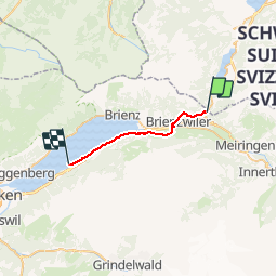
Ruta Otra actividad de 17,4 km a descubrir en Berna, Verwaltungskreis Interlaken-Oberhasli, Meiringen. Esta ruta ha sido propuesta por hallauer.
Descripción
Pilgerwanderung vom Brünig nach Interlaken über die Giessbachfälle nach Iseltwald. Mit dem Schiff nach Interlaken
Localización
País:
Switzerland
Región :
Berna
Departamento/provincia :
Verwaltungskreis Interlaken-Oberhasli
Municipio :
Meiringen
Localidad:
Unknown
Salida:(Dec)
Salida:(UTM)
434205 ; 5178596 (32T) N.
Comentarios
Excursiones cerca
![Excursión A pie Lungern - Dundelegg - Turren - Photo](https://media.geolcdn.com/t/375/260/ext.jpg?maxdim=2&url=https%3A%2F%2Fmedia.geolcdn.com%2Ff%2Fac579432-b8a5-41b8-882b-271764c02474.jpeg)
![A pie A pie](https://static1.geolcdn.com/sitytour/trail-icons/100.png)
Dundelegg - Turren
A pie
Fácil
Lungern,
Obwalden,
Desconocido,
Switzerland
![](/images/other/stat-length.png)
3,1 km | 4,6 km-effort
1h 2min
![](https://static1.geolcdn.com/siteimages/upload/files/16400158638029165_repeat_loop_refresh_sync_direction_icon.png)
No
![Excursión A pie Lungern - Schmetterlingspfad Lungern - Photo](https://media.geolcdn.com/t/375/260/ext.jpg?maxdim=2&url=https%3A%2F%2Fmedia.geolcdn.com%2Ff%2Fac579432-b8a5-41b8-882b-271764c02474.jpeg)
![A pie A pie](https://static1.geolcdn.com/sitytour/trail-icons/100.png)
Schmetterlingspfad Lungern
A pie
Fácil
Lungern,
Obwalden,
Desconocido,
Switzerland
![](/images/other/stat-length.png)
4,1 km | 7,3 km-effort
1h 39min
![](https://static1.geolcdn.com/siteimages/upload/files/16400158638029165_repeat_loop_refresh_sync_direction_icon.png)
No
![Excursión A pie Giswil - Mittlist Arni - Arnihaaggen - Photo](https://media.geolcdn.com/t/375/260/ext.jpg?maxdim=2&url=https%3A%2F%2Fmedia.geolcdn.com%2Ff%2F88098cf0-8aa1-47bb-95dd-ff8e70c75dca.jpeg)
![A pie A pie](https://static1.geolcdn.com/sitytour/trail-icons/100.png)
Mittlist Arni - Arnihaaggen
A pie
Fácil
Giswil,
Obwalden,
Desconocido,
Switzerland
![](/images/other/stat-length.png)
3,4 km | 9,3 km-effort
2h 6min
![](https://static1.geolcdn.com/siteimages/upload/files/16400158638029165_repeat_loop_refresh_sync_direction_icon.png)
No
![Excursión Otra actividad Meiringen - ViaRegio_Jungfrau_2 - Photo](https://media.geolcdn.com/t/375/260/ext.jpg?maxdim=2&url=https%3A%2F%2Fstatic1.geolcdn.com%2Fsiteimages%2Fupload%2Ffiles%2F1545311037marcheuse_200dpi.jpg)
![Otra actividad Otra actividad](https://static1.geolcdn.com/sitytour/trail-icons/900.png)
ViaRegio_Jungfrau_2
Otra actividad
Muy fácil
Meiringen,
Berna,
Verwaltungskreis Interlaken-Oberhasli,
Switzerland
![](/images/other/stat-length.png)
13,8 km | 28 km-effort
6h 57min
![](https://static1.geolcdn.com/siteimages/upload/files/16400158638029165_repeat_loop_refresh_sync_direction_icon.png)
No
![Excursión Senderismo Lungern - Schmetterlingspfad - Photo](https://media.geolcdn.com/t/375/260/ext.jpg?maxdim=2&url=https%3A%2F%2Fstatic1.geolcdn.com%2Fsiteimages%2Fupload%2Ffiles%2F1553511878bg_sport_marche.png)
![Senderismo Senderismo](https://static1.geolcdn.com/sitytour/trail-icons/101.png)
Schmetterlingspfad
Senderismo
Muy fácil
Lungern,
Obwalden,
Desconocido,
Switzerland
![](/images/other/stat-length.png)
16,7 km | 34 km-effort
Desconocido
![](https://static1.geolcdn.com/siteimages/upload/files/16400158638029165_repeat_loop_refresh_sync_direction_icon.png)
Sí
![Excursión Bicicleta Hofstetten bei Brienz - st_ral_09_04 - Photo](https://media.geolcdn.com/t/375/260/ext.jpg?maxdim=2&url=https%3A%2F%2Fstatic1.geolcdn.com%2Fsiteimages%2Fupload%2Ffiles%2F1524743154velo.jpg)
![Bicicleta Bicicleta](https://static1.geolcdn.com/sitytour/trail-icons/200.png)
st_ral_09_04
Bicicleta
Muy fácil
Hofstetten bei Brienz,
Berna,
Verwaltungskreis Interlaken-Oberhasli,
Switzerland
![](/images/other/stat-length.png)
20 km | 26 km-effort
4h 46min
![](https://static1.geolcdn.com/siteimages/upload/files/16400158638029165_repeat_loop_refresh_sync_direction_icon.png)
No
![Excursión Senderismo Meiringen - sf_e9b - Photo](https://media.geolcdn.com/t/375/260/ext.jpg?maxdim=2&url=https%3A%2F%2Fstatic1.geolcdn.com%2Fsiteimages%2Fupload%2Ffiles%2F1553511878bg_sport_marche.png)
![Senderismo Senderismo](https://static1.geolcdn.com/sitytour/trail-icons/101.png)
sf_e9b
Senderismo
Muy fácil
Meiringen,
Berna,
Verwaltungskreis Interlaken-Oberhasli,
Switzerland
![](/images/other/stat-length.png)
21 km | 38 km-effort
6h 44min
![](https://static1.geolcdn.com/siteimages/upload/files/16400158638029165_repeat_loop_refresh_sync_direction_icon.png)
No
![Excursión Otra actividad Meiringen - Axalp - Meiringen /2 - Photo](https://media.geolcdn.com/t/375/260/ext.jpg?maxdim=2&url=https%3A%2F%2Fstatic1.geolcdn.com%2Fsiteimages%2Fupload%2Ffiles%2F1545311037marcheuse_200dpi.jpg)
![Otra actividad Otra actividad](https://static1.geolcdn.com/sitytour/trail-icons/900.png)
Axalp - Meiringen /2
Otra actividad
Muy fácil
Meiringen,
Berna,
Verwaltungskreis Interlaken-Oberhasli,
Switzerland
![](/images/other/stat-length.png)
6,5 km | 8,6 km-effort
Desconocido
![](https://static1.geolcdn.com/siteimages/upload/files/16400158638029165_repeat_loop_refresh_sync_direction_icon.png)
No
![Excursión Otra actividad Brienzwiler - JW Brünig Iseltwald Teil 3 - Photo](https://media.geolcdn.com/t/375/260/ext.jpg?maxdim=2&url=https%3A%2F%2Fstatic1.geolcdn.com%2Fsiteimages%2Fupload%2Ffiles%2F1545311037marcheuse_200dpi.jpg)
![Otra actividad Otra actividad](https://static1.geolcdn.com/sitytour/trail-icons/900.png)
JW Brünig Iseltwald Teil 3
Otra actividad
Muy fácil
Brienzwiler,
Berna,
Verwaltungskreis Interlaken-Oberhasli,
Switzerland
![](/images/other/stat-length.png)
5,9 km | 7,5 km-effort
Desconocido
![](https://static1.geolcdn.com/siteimages/upload/files/16400158638029165_repeat_loop_refresh_sync_direction_icon.png)
No