![](/images/other/stat-length.png)
![Excursión Senderismo Saint-Raphaël - Autour du pic de l'Ours - Photo](https://media.geolcdn.com/t/1900/400/e57892d6-e8f3-4ab5-8dfe-0a5f3531a9c7.jpg&format=pjpeg&maxdim=2)
Autour du pic de l'Ours
ETMU5496
Usuario
![Longitud](/images/other/stat-length.png)
![Altitud máxima](https://static1.geolcdn.com/siteimages/upload/files/1508320355ic_sort_altitude_max_24dp.png)
![Desnivel positivo](https://static1.geolcdn.com/siteimages/upload/files/1508320355ic_sort_den_pos_24dp.png)
![Km-Effort](/images/other/stat-length.png)
![Altitud mínima](https://static1.geolcdn.com/siteimages/upload/files/1508320355ic_sort_altitude_min_24dp.png)
![Desnivel negativo](https://static1.geolcdn.com/siteimages/upload/files/1508320355ic_sort_den_neg_24dp.png)
![Boucle](https://static1.geolcdn.com/siteimages/upload/files/16400158638029165_repeat_loop_refresh_sync_direction_icon.png)
![Senderismo](https://static1.geolcdn.com/sitytour/trail-icons/101.png)
6h00
Dificultad : Medio
![Escanee este código QR para abrir la excursión en la aplicación SityTrail](https://capi.geolives.com/qq0zvz2zws4bq2lad0pu/sitytour/trails/2221940/qr.png?size=200)
Aplicación GPS de excursión GRATIS
A propósito
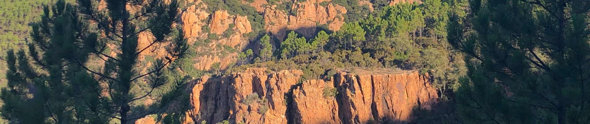
Ruta Senderismo de 20 km a descubrir en Provenza-Alpes-Costa Azul, Var, Saint-Raphaël. Esta ruta ha sido propuesta por ETMU5496.
Descripción
Belle randonnée au départ du col de Belle Barbe.
On longe le lac du Grenouillet en direction de celui de l'écureuil.
On bifurque peu après le gué vers le ravin du Grenouillet. On monte jusqu'à la baisse orientale (beau point de vue), puis jusqu'à la baisse des sangliers. On prend le sentier en direction du pic d'Orelle mais on bifurque vers le col des lentisques. On monte ensuite au Pic de l'Ours puis on redescend vers le col Notre Dame via la dent de l'Ours.
Après la pause repas, on redescend par la piste goudronnée vers le col de Cadière. On poursuit jusqu'à une bifurcation indiquant le lac de l'écureuil que l'on rejoint après une longue descente caillouteuse.
On poursuit par le vallon du Mal Infernet et à mi chemin, on bifurque sur la passerelle en empruntant le GR qui monte au col d'Aubert. Retour au parking de Belle Barbe ensuite.
Localización
Comentarios
Excursiones cerca
![Excursión Senderismo Saint-Raphaël - Sommet du Bonnet de Capelan - Photo](https://media.geolcdn.com/t/375/260/05863c9a-49da-4f41-9bfb-5d37c8a1781d.jpg&format=jpg&maxdim=2)
![Senderismo Senderismo](https://static1.geolcdn.com/sitytour/trail-icons/101.png)
Senderismo
![](/images/other/stat-length.png)
![](https://static1.geolcdn.com/siteimages/upload/files/16400158638029165_repeat_loop_refresh_sync_direction_icon.png)
![Excursión Senderismo Saint-Raphaël - Massif d'ésterel-grande boucle pic cap roux - Photo](https://media.geolcdn.com/t/375/260/75f5531d-898d-4f51-8086-6652c6aad722.jpg&format=jpg&maxdim=2)
![Senderismo Senderismo](https://static1.geolcdn.com/sitytour/trail-icons/101.png)
Senderismo
![](/images/other/stat-length.png)
![](https://static1.geolcdn.com/siteimages/upload/files/16400158638029165_repeat_loop_refresh_sync_direction_icon.png)
![Excursión Senderismo Saint-Raphaël - Les lacs par les rochers du Caneiret - Photo](https://media.geolcdn.com/t/375/260/cddead80-47f3-4091-93b3-1398b473dc08.jpg&format=jpg&maxdim=2)
![Senderismo Senderismo](https://static1.geolcdn.com/sitytour/trail-icons/101.png)
Senderismo
![](/images/other/stat-length.png)
![](https://static1.geolcdn.com/siteimages/upload/files/16400158638029165_repeat_loop_refresh_sync_direction_icon.png)
![Excursión Senderismo Saint-Raphaël - le Dramont - Photo](https://media.geolcdn.com/t/375/260/83d1f287-d047-452c-844a-302c6891c476.jpg&format=jpg&maxdim=2)
![Senderismo Senderismo](https://static1.geolcdn.com/sitytour/trail-icons/101.png)
Senderismo
![](/images/other/stat-length.png)
![](https://static1.geolcdn.com/siteimages/upload/files/16400158638029165_repeat_loop_refresh_sync_direction_icon.png)
![Excursión Senderismo Saint-Raphaël - Le tour du Pic du Cap Roux - St Raphaël (Agay) - Photo](https://media.geolcdn.com/t/375/260/ext.jpg?maxdim=2&url=https%3A%2F%2Fservices.sitytrail.com%2FGeolivesWS%2FDownloadMedia.ashx%3FTrailID%3D317929%26Media%3D17353_6.jpg)
![Senderismo Senderismo](https://static1.geolcdn.com/sitytour/trail-icons/101.png)
Senderismo
![](/images/other/stat-length.png)
![](https://static1.geolcdn.com/siteimages/upload/files/16400158638029165_repeat_loop_refresh_sync_direction_icon.png)
![Excursión Senderismo Saint-Raphaël - Pic du Cap Roux - Photo](https://media.geolcdn.com/t/375/260/ext.jpg?maxdim=2&url=https%3A%2F%2Fservices.sitytrail.com%2FGeolivesWS%2FDownloadMedia.ashx%3FTrailID%3D230669%26Media%3Dfix__20131103111411.jpg)
![Senderismo Senderismo](https://static1.geolcdn.com/sitytour/trail-icons/101.png)
Senderismo
![](/images/other/stat-length.png)
![](https://static1.geolcdn.com/siteimages/upload/files/16400158638029165_repeat_loop_refresh_sync_direction_icon.png)
![Excursión Senderismo Saint-Raphaël - SityTrail - ND - Aiguille - Photo](https://media.geolcdn.com/t/375/260/ext.jpg?maxdim=2&url=https%3A%2F%2Fstatic1.geolcdn.com%2Fsiteimages%2Fupload%2Ffiles%2F1553511878bg_sport_marche.png)
![Senderismo Senderismo](https://static1.geolcdn.com/sitytour/trail-icons/101.png)
Senderismo
![](/images/other/stat-length.png)
![](https://static1.geolcdn.com/siteimages/upload/files/16400158638029165_repeat_loop_refresh_sync_direction_icon.png)
![Excursión Senderismo Saint-Raphaël - Agay - Sainte-Barbe - Étang des Nénuphares - Photo](https://media.geolcdn.com/t/375/260/dfb7073a-02d4-4811-84ba-99dc2878a0d2.jpg&format=jpg&maxdim=2)
![Senderismo Senderismo](https://static1.geolcdn.com/sitytour/trail-icons/101.png)
Senderismo
![](/images/other/stat-length.png)
![](https://static1.geolcdn.com/siteimages/upload/files/16400158638029165_repeat_loop_refresh_sync_direction_icon.png)
![Excursión Senderismo Saint-Raphaël - Tour du Pic de l'Ours - Le Trayas - Photo](https://media.geolcdn.com/t/375/260/ext.jpg?maxdim=2&url=https%3A%2F%2Fservices.sitytrail.com%2FGeolivesWS%2FDownloadMedia.ashx%3FTrailID%3D191486%26Media%3D15078_2.jpg)
![Senderismo Senderismo](https://static1.geolcdn.com/sitytour/trail-icons/101.png)
Senderismo
![](/images/other/stat-length.png)
![](https://static1.geolcdn.com/siteimages/upload/files/16400158638029165_repeat_loop_refresh_sync_direction_icon.png)