![](/images/other/stat-length.png)
![Excursión Senderismo Revel - Col du Loup - Col de la Sitre en boucle - Photo](https://media.geolcdn.com/t/1900/400/3b3fd5f2-a552-4482-81db-93310043ddd9.jpg&format=pjpeg&maxdim=2)
Col du Loup - Col de la Sitre en boucle
patjobou
Usuario
![Longitud](/images/other/stat-length.png)
Longitud
15,8 km
![Altitud máxima](https://static1.geolcdn.com/siteimages/upload/files/1508320355ic_sort_altitude_max_24dp.png)
Altitud máxima
2372 m
![Desnivel positivo](https://static1.geolcdn.com/siteimages/upload/files/1508320355ic_sort_den_pos_24dp.png)
Desnivel positivo
1167 m
![Km-Effort](/images/other/stat-length.png)
Km-Effort
31 km
![Altitud mínima](https://static1.geolcdn.com/siteimages/upload/files/1508320355ic_sort_altitude_min_24dp.png)
Altitud mínima
1381 m
![Desnivel negativo](https://static1.geolcdn.com/siteimages/upload/files/1508320355ic_sort_den_neg_24dp.png)
Desnivel negativo
1168 m
![Boucle](https://static1.geolcdn.com/siteimages/upload/files/16400158638029165_repeat_loop_refresh_sync_direction_icon.png)
Boucle
Sí
Fecha de creación :
2019-10-03 07:05:52.271
Última modificación :
2019-10-06 17:30:37.425
![Senderismo](https://static1.geolcdn.com/sitytour/trail-icons/101.png)
7h26
Dificultad : Difícil
![Escanee este código QR para abrir la excursión en la aplicación SityTrail](https://capi.geolives.com/qq0zvz2zws4bq2lad0pu/sitytour/trails/2221056/qr.png?size=200)
Aplicación GPS de excursión GRATIS
A propósito
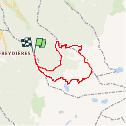
Ruta Senderismo de 15,8 km a descubrir en Auvergne-Rhône-Alpes, Isère, Revel. Esta ruta ha sido propuesta por patjobou.
Descripción
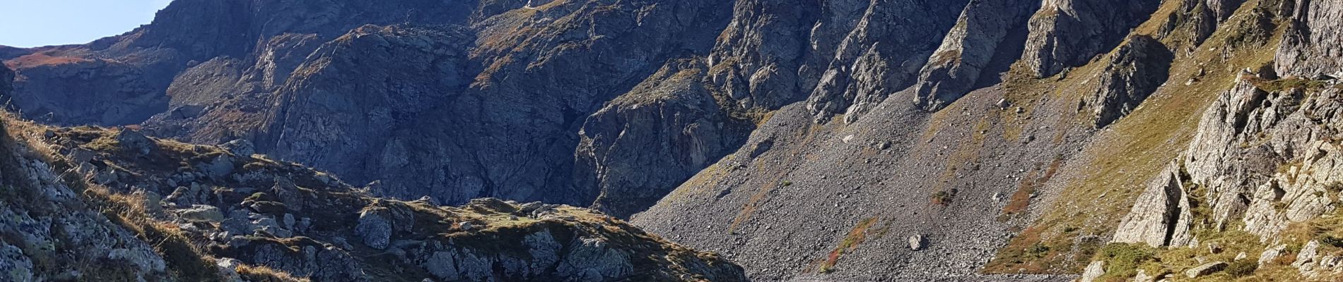
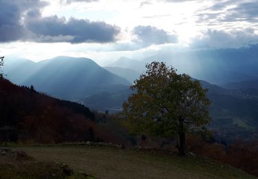
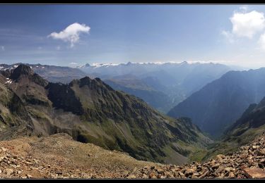
Une très belle boucle avec des paysages très variés. Belle traversée sauvage entre le col du Loup et le col de La Sitre. A faire par beau temps sec. Du col du Loup, il est possible l'aller justqu'à la Petite Lance du Crozet par la crete.
Localización
País:
France
Región :
Auvergne-Rhône-Alpes
Departamento/provincia :
Isère
Municipio :
Revel
Localidad:
Unknown
Salida:(Dec)
Salida:(UTM)
728845 ; 5007813 (31T) N.
Comentarios
Excursiones cerca
![Excursión A pie La Combe-de-Lancey - Chemin de Découverte (boucle Haute) - Photo](https://media.geolcdn.com/t/375/260/6a0cb0d1-93da-4068-99ad-9a549161cacf.jpeg&format=jpg&maxdim=2)
![A pie A pie](https://static1.geolcdn.com/sitytour/trail-icons/100.png)
Chemin de Découverte (boucle Haute)
A pie
Fácil
La Combe-de-Lancey,
Auvergne-Rhône-Alpes,
Isère,
France
![](/images/other/stat-length.png)
3,5 km | 5,4 km-effort
1h 13min
![](https://static1.geolcdn.com/siteimages/upload/files/16400158638029165_repeat_loop_refresh_sync_direction_icon.png)
Sí
![Excursión A pie Saint-Jean-le-Vieux - La Tour de Revel (par le Mollard) - Photo](https://media.geolcdn.com/t/375/260/9b2599de-7f79-405c-8210-bdfecfa7c849.jpeg&format=jpg&maxdim=2)
![A pie A pie](https://static1.geolcdn.com/sitytour/trail-icons/100.png)
La Tour de Revel (par le Mollard)
A pie
Fácil
Saint-Jean-le-Vieux,
Auvergne-Rhône-Alpes,
Isère,
France
![](/images/other/stat-length.png)
7,9 km | 13,4 km-effort
3h 2min
![](https://static1.geolcdn.com/siteimages/upload/files/16400158638029165_repeat_loop_refresh_sync_direction_icon.png)
No
![Excursión Senderismo Saint-Martin-d'Uriage - Les Seiglières. Circuit des Gardes n°9 raccourci à 8 km - Photo](https://media.geolcdn.com/t/375/260/e86aee80-f13d-4d4a-be38-285e5f19658e.jpg&format=jpg&maxdim=2)
![Senderismo Senderismo](https://static1.geolcdn.com/sitytour/trail-icons/101.png)
Les Seiglières. Circuit des Gardes n°9 raccourci à 8 km
Senderismo
Medio
Saint-Martin-d'Uriage,
Auvergne-Rhône-Alpes,
Isère,
France
![](/images/other/stat-length.png)
8,1 km | 12,6 km-effort
2h 51min
![](https://static1.geolcdn.com/siteimages/upload/files/16400158638029165_repeat_loop_refresh_sync_direction_icon.png)
Sí
![Excursión Senderismo La Combe-de-Lancey - Col du Pré du Molard - Photo](https://media.geolcdn.com/t/375/260/29dc783a-080e-448f-b06b-b4c5ed8fc906.jpg&format=jpg&maxdim=2)
![Senderismo Senderismo](https://static1.geolcdn.com/sitytour/trail-icons/101.png)
Col du Pré du Molard
Senderismo
Difícil
La Combe-de-Lancey,
Auvergne-Rhône-Alpes,
Isère,
France
![](/images/other/stat-length.png)
17,8 km | 33 km-effort
5h 19min
![](https://static1.geolcdn.com/siteimages/upload/files/16400158638029165_repeat_loop_refresh_sync_direction_icon.png)
Sí
![Excursión Senderismo Saint-Mury-Monteymond - Lac Blanc au pied de Belledonne - Photo](https://media.geolcdn.com/t/375/260/be8bcf54-d056-4226-93e0-f27b8cc25845.jpg&format=jpg&maxdim=2)
![Senderismo Senderismo](https://static1.geolcdn.com/sitytour/trail-icons/101.png)
Lac Blanc au pied de Belledonne
Senderismo
Muy difícil
Saint-Mury-Monteymond,
Auvergne-Rhône-Alpes,
Isère,
France
![](/images/other/stat-length.png)
12,2 km | 26 km-effort
5h 49min
![](https://static1.geolcdn.com/siteimages/upload/files/16400158638029165_repeat_loop_refresh_sync_direction_icon.png)
Sí
![Excursión Senderismo Revel - Montagne 15/08/2023 - Photo](https://media.geolcdn.com/t/375/260/ca509cb3-3847-45e2-a337-c41964fdee08.jpg&format=jpg&maxdim=2)
![Senderismo Senderismo](https://static1.geolcdn.com/sitytour/trail-icons/101.png)
Montagne 15/08/2023
Senderismo
Difícil
Revel,
Auvergne-Rhône-Alpes,
Isère,
France
![](/images/other/stat-length.png)
16,2 km | 32 km-effort
6h 36min
![](https://static1.geolcdn.com/siteimages/upload/files/16400158638029165_repeat_loop_refresh_sync_direction_icon.png)
Sí
![Excursión Senderismo Saint-Mury-Monteymond - Col et Pointe de la Sitre - Photo](https://media.geolcdn.com/t/375/260/12aa835d-a61b-4dc5-8899-8748a81192a8.jpg&format=jpg&maxdim=2)
![Senderismo Senderismo](https://static1.geolcdn.com/sitytour/trail-icons/101.png)
Col et Pointe de la Sitre
Senderismo
Muy difícil
Saint-Mury-Monteymond,
Auvergne-Rhône-Alpes,
Isère,
France
![](/images/other/stat-length.png)
11,2 km | 23 km-effort
5h 14min
![](https://static1.geolcdn.com/siteimages/upload/files/16400158638029165_repeat_loop_refresh_sync_direction_icon.png)
Sí
![Excursión Senderismo Saint-Martin-d'Uriage - Circuit des Gardes - Photo](https://media.geolcdn.com/t/375/260/5aace18d-b6a8-46a3-a2a8-ee9515f27ad2.jpg&format=jpg&maxdim=2)
![Senderismo Senderismo](https://static1.geolcdn.com/sitytour/trail-icons/101.png)
Circuit des Gardes
Senderismo
Fácil
Saint-Martin-d'Uriage,
Auvergne-Rhône-Alpes,
Isère,
France
![](/images/other/stat-length.png)
15,6 km | 23 km-effort
5h 49min
![](https://static1.geolcdn.com/siteimages/upload/files/16400158638029165_repeat_loop_refresh_sync_direction_icon.png)
Sí
![Excursión Senderismo Revel - Grande Lauziere - Photo](https://media.geolcdn.com/t/375/260/6ecc9c2a-cff5-4a21-8446-c2fd0ace6af6.jpg&format=jpg&maxdim=2)
![Senderismo Senderismo](https://static1.geolcdn.com/sitytour/trail-icons/101.png)
Grande Lauziere
Senderismo
Difícil
Revel,
Auvergne-Rhône-Alpes,
Isère,
France
![](/images/other/stat-length.png)
22 km | 42 km-effort
8h 18min
![](https://static1.geolcdn.com/siteimages/upload/files/16400158638029165_repeat_loop_refresh_sync_direction_icon.png)
Sí