![](/images/other/stat-length.png)
![Excursión Senderismo Unknown - becici de Iberostar à St Stéphane A)R - Photo](https://media.geolcdn.com/t/1900/400/ext.pjpeg?maxdim=2&url=https%3A%2F%2Fstatic1.geolcdn.com%2Fsiteimages%2Fupload%2Ffiles%2F1553511878bg_sport_marche.png)
becici de Iberostar à St Stéphane A)R
papiou
Usuario
![Longitud](/images/other/stat-length.png)
Longitud
7,6 km
![Altitud máxima](https://static1.geolcdn.com/siteimages/upload/files/1508320355ic_sort_altitude_max_24dp.png)
Altitud máxima
56 m
![Desnivel positivo](https://static1.geolcdn.com/siteimages/upload/files/1508320355ic_sort_den_pos_24dp.png)
Desnivel positivo
154 m
![Km-Effort](/images/other/stat-length.png)
Km-Effort
9,7 km
![Altitud mínima](https://static1.geolcdn.com/siteimages/upload/files/1508320355ic_sort_altitude_min_24dp.png)
Altitud mínima
-1 m
![Desnivel negativo](https://static1.geolcdn.com/siteimages/upload/files/1508320355ic_sort_den_neg_24dp.png)
Desnivel negativo
155 m
![Boucle](https://static1.geolcdn.com/siteimages/upload/files/16400158638029165_repeat_loop_refresh_sync_direction_icon.png)
Boucle
Sí
Fecha de creación :
2019-09-29 05:20:24.649
Última modificación :
2019-09-29 09:45:24.944
![Senderismo](https://static1.geolcdn.com/sitytour/trail-icons/101.png)
1h23
Dificultad : Medio
![Escanee este código QR para abrir la excursión en la aplicación SityTrail](https://capi.geolives.com/qq0zvz2zws4bq2lad0pu/sitytour/trails/2216883/qr.png?size=200)
Aplicación GPS de excursión GRATIS
A propósito
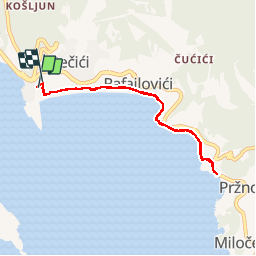
Ruta Senderismo de 7,6 km a descubrir en Desconocido, Municipio de Budva. Esta ruta ha sido propuesta por papiou.
Descripción
Départ scène de l'hôtel, rejoindre la plage et prendre à gauche jusque la plage privée de St Stéphane. possibilité de rejoindre l'entrée de l'île par la route
Localización
País:
Montenegro
Región :
Desconocido
Departamento/provincia :
Municipio de Budva
Municipio :
Unknown
Localidad:
Unknown
Salida:(Dec)
Salida:(UTM)
323587 ; 4683246 (34T) N.
Comentarios
Excursiones cerca
![Excursión Senderismo - becici découverte bord de mer - Photo](https://media.geolcdn.com/t/375/260/fe5844ca-da47-41c0-a3ce-7c32fd744a1b.jpg&format=jpg&maxdim=2)
![Senderismo Senderismo](https://static1.geolcdn.com/sitytour/trail-icons/101.png)
becici découverte bord de mer
Senderismo
Fácil
,
Desconocido,
Municipio de Budva,
Montenegro
![](/images/other/stat-length.png)
3,7 km | 4,8 km-effort
1h 1min
![](https://static1.geolcdn.com/siteimages/upload/files/16400158638029165_repeat_loop_refresh_sync_direction_icon.png)
Sí
![Excursión Senderismo - MNE_Becici_Pm_190424 - Photo](https://media.geolcdn.com/t/375/260/ext.jpg?maxdim=2&url=https%3A%2F%2Fstatic1.geolcdn.com%2Fsiteimages%2Fupload%2Ffiles%2F1553511878bg_sport_marche.png)
![Senderismo Senderismo](https://static1.geolcdn.com/sitytour/trail-icons/101.png)
MNE_Becici_Pm_190424
Senderismo
Muy fácil
,
Desconocido,
Municipio de Budva,
Montenegro
![](/images/other/stat-length.png)
8,8 km | 10,5 km-effort
3h 28min
![](https://static1.geolcdn.com/siteimages/upload/files/16400158638029165_repeat_loop_refresh_sync_direction_icon.png)
Sí
![Excursión Senderismo - MNE_Becici_A,M_190424 - Photo](https://media.geolcdn.com/t/375/260/ext.jpg?maxdim=2&url=https%3A%2F%2Fstatic1.geolcdn.com%2Fsiteimages%2Fupload%2Ffiles%2F1553511878bg_sport_marche.png)
![Senderismo Senderismo](https://static1.geolcdn.com/sitytour/trail-icons/101.png)
MNE_Becici_A,M_190424
Senderismo
Muy fácil
,
Desconocido,
Municipio de Budva,
Montenegro
![](/images/other/stat-length.png)
5,4 km | 6,1 km-effort
2h 25min
![](https://static1.geolcdn.com/siteimages/upload/files/16400158638029165_repeat_loop_refresh_sync_direction_icon.png)
Sí
![Excursión Senderismo - MNE_Becici_180424 - Photo](https://media.geolcdn.com/t/375/260/ext.jpg?maxdim=2&url=https%3A%2F%2Fstatic1.geolcdn.com%2Fsiteimages%2Fupload%2Ffiles%2F1553511878bg_sport_marche.png)
![Senderismo Senderismo](https://static1.geolcdn.com/sitytour/trail-icons/101.png)
MNE_Becici_180424
Senderismo
Muy fácil
,
Desconocido,
Municipio de Budva,
Montenegro
![](/images/other/stat-length.png)
4,3 km | 5,3 km-effort
2h 6min
![](https://static1.geolcdn.com/siteimages/upload/files/16400158638029165_repeat_loop_refresh_sync_direction_icon.png)
Sí
![Excursión Coche - MNE_170424_Lac_ Skadar - Photo](https://media.geolcdn.com/t/375/260/ext.jpg?maxdim=2&url=https%3A%2F%2Fstatic1.geolcdn.com%2Fsiteimages%2Fupload%2Ffiles%2F15247431544x4.jpg)
![Coche Coche](https://static1.geolcdn.com/sitytour/trail-icons/401.png)
MNE_170424_Lac_ Skadar
Coche
Muy fácil
,
Desconocido,
Municipio de Budva,
Montenegro
![](/images/other/stat-length.png)
127 km | 174 km-effort
9h 7min
![](https://static1.geolcdn.com/siteimages/upload/files/16400158638029165_repeat_loop_refresh_sync_direction_icon.png)
Sí
![Excursión Senderismo - MNE_Budva_160424 - Photo](https://media.geolcdn.com/t/375/260/ext.jpg?maxdim=2&url=https%3A%2F%2Fstatic1.geolcdn.com%2Fsiteimages%2Fupload%2Ffiles%2F1553511878bg_sport_marche.png)
![Senderismo Senderismo](https://static1.geolcdn.com/sitytour/trail-icons/101.png)
MNE_Budva_160424
Senderismo
Muy fácil
,
Desconocido,
Municipio de Budva,
Montenegro
![](/images/other/stat-length.png)
7,6 km | 8,8 km-effort
3h 16min
![](https://static1.geolcdn.com/siteimages/upload/files/16400158638029165_repeat_loop_refresh_sync_direction_icon.png)
Sí
![Excursión Coche - MNE_150424_KOTOR - Photo](https://media.geolcdn.com/t/375/260/ext.jpg?maxdim=2&url=https%3A%2F%2Fstatic1.geolcdn.com%2Fsiteimages%2Fupload%2Ffiles%2F15247431544x4.jpg)
![Coche Coche](https://static1.geolcdn.com/sitytour/trail-icons/401.png)
MNE_150424_KOTOR
Coche
Muy fácil
,
Desconocido,
Municipio de Budva,
Montenegro
![](/images/other/stat-length.png)
40 km | 49 km-effort
3h 31min
![](https://static1.geolcdn.com/siteimages/upload/files/16400158638029165_repeat_loop_refresh_sync_direction_icon.png)
No
![Excursión Senderismo - Mne_140424_5_4 - Photo](https://media.geolcdn.com/t/375/260/ext.jpg?maxdim=2&url=https%3A%2F%2Fstatic1.geolcdn.com%2Fsiteimages%2Fupload%2Ffiles%2F1553511878bg_sport_marche.png)
![Senderismo Senderismo](https://static1.geolcdn.com/sitytour/trail-icons/101.png)
Mne_140424_5_4
Senderismo
Muy fácil
,
Desconocido,
Municipio de Budva,
Montenegro
![](/images/other/stat-length.png)
5,9 km | 7,2 km-effort
2h 59min
![](https://static1.geolcdn.com/siteimages/upload/files/16400158638029165_repeat_loop_refresh_sync_direction_icon.png)
No
![Excursión Senderismo - MNE_180424 - Photo](https://media.geolcdn.com/t/375/260/ext.jpg?maxdim=2&url=https%3A%2F%2Fstatic1.geolcdn.com%2Fsiteimages%2Fupload%2Ffiles%2F1553511878bg_sport_marche.png)
![Senderismo Senderismo](https://static1.geolcdn.com/sitytour/trail-icons/101.png)
MNE_180424
Senderismo
Muy fácil
,
Desconocido,
Municipio de Budva,
Montenegro
![](/images/other/stat-length.png)
2,6 km | 3,5 km-effort
2h 29min
![](https://static1.geolcdn.com/siteimages/upload/files/16400158638029165_repeat_loop_refresh_sync_direction_icon.png)
Sí