![](/images/other/stat-length.png)
![Excursión Senderismo El Havre - Le Havre de la plage aux jardins suspendus - Photo](https://media.geolcdn.com/t/1900/400/3ab9b6bb-ea38-47b7-8889-9537493f2269.jpg&format=pjpeg&maxdim=2)
Le Havre de la plage aux jardins suspendus
zazie
Usuario
![Longitud](/images/other/stat-length.png)
Longitud
22 km
![Altitud máxima](https://static1.geolcdn.com/siteimages/upload/files/1508320355ic_sort_altitude_max_24dp.png)
Altitud máxima
98 m
![Desnivel positivo](https://static1.geolcdn.com/siteimages/upload/files/1508320355ic_sort_den_pos_24dp.png)
Desnivel positivo
333 m
![Km-Effort](/images/other/stat-length.png)
Km-Effort
27 km
![Altitud mínima](https://static1.geolcdn.com/siteimages/upload/files/1508320355ic_sort_altitude_min_24dp.png)
Altitud mínima
-2 m
![Desnivel negativo](https://static1.geolcdn.com/siteimages/upload/files/1508320355ic_sort_den_neg_24dp.png)
Desnivel negativo
333 m
![Boucle](https://static1.geolcdn.com/siteimages/upload/files/16400158638029165_repeat_loop_refresh_sync_direction_icon.png)
Boucle
Sí
Fecha de creación :
2019-09-25 13:27:30.712
Última modificación :
2019-09-25 16:52:15.849
![Senderismo](https://static1.geolcdn.com/sitytour/trail-icons/101.png)
5h00
Dificultad : Medio
![Carrera](https://static1.geolcdn.com/sitytour/trail-icons/103.png)
3h00
Dificultad : Medio
![Escanee este código QR para abrir la excursión en la aplicación SityTrail](https://capi.geolives.com/qq0zvz2zws4bq2lad0pu/sitytour/trails/2213935/qr.png?size=200)
Aplicación GPS de excursión GRATIS
A propósito
Ruta Senderismo de 22 km a descubrir en Normandía, Sena-Marítimo, El Havre. Esta ruta ha sido propuesta por zazie.
Descripción
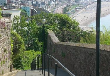
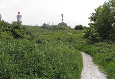
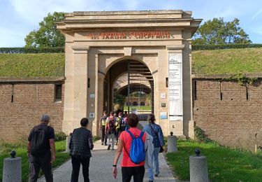
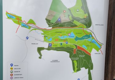
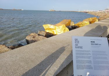
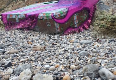
Promenade à travers quelques éléments clés de la ville du Havre en passant par les ports, la plage, les anciennes fortifications de l'estuaire, les jardins suspendus, de nombreuses marches pour de belles petites ruelles. Prévoir casse croûte et boissons.
Localización
País:
France
Región :
Normandía
Departamento/provincia :
Sena-Marítimo
Municipio :
El Havre
Localidad:
Unknown
Salida:(Dec)
Salida:(UTM)
291836 ; 5486272 (31U) N.
Comentarios
Excursiones cerca
![Excursión Senderismo El Havre - Découvrir Le Havre - Photo](https://media.geolcdn.com/t/375/260/ext.jpg?maxdim=2&url=https%3A%2F%2Fservices.sitytrail.com%2FGeolivesWS%2FDownloadMedia.ashx%3FTrailID%3D173067%26Media%3D14597_6.jpg)
![Senderismo Senderismo](https://static1.geolcdn.com/sitytour/trail-icons/101.png)
Découvrir Le Havre
Senderismo
Difícil
(1)
El Havre,
Normandía,
Sena-Marítimo,
France
![](/images/other/stat-length.png)
14,2 km | 17 km-effort
3h 30min
![](https://static1.geolcdn.com/siteimages/upload/files/16400158638029165_repeat_loop_refresh_sync_direction_icon.png)
Sí
![Excursión A pie Fontaine-la-Mallet - Les Bassins des Vallées - Photo](https://media.geolcdn.com/t/375/260/ce57ffe6-f4ea-486c-bc79-47861158f9a7.jpeg&format=jpg&maxdim=2)
![A pie A pie](https://static1.geolcdn.com/sitytour/trail-icons/100.png)
Les Bassins des Vallées
A pie
Fácil
Fontaine-la-Mallet,
Normandía,
Sena-Marítimo,
France
![](/images/other/stat-length.png)
5,1 km | 6 km-effort
1h 21min
![](https://static1.geolcdn.com/siteimages/upload/files/16400158638029165_repeat_loop_refresh_sync_direction_icon.png)
No
![Excursión A pie El Havre - Autour du Cap - Photo](https://media.geolcdn.com/t/375/260/5d7ac9de-0a46-49c7-8cfc-4f8d63e71135.jpeg&format=jpg&maxdim=2)
![A pie A pie](https://static1.geolcdn.com/sitytour/trail-icons/100.png)
Autour du Cap
A pie
Fácil
El Havre,
Normandía,
Sena-Marítimo,
France
![](/images/other/stat-length.png)
4,8 km | 5,9 km-effort
1h 20min
![](https://static1.geolcdn.com/siteimages/upload/files/16400158638029165_repeat_loop_refresh_sync_direction_icon.png)
No
![Excursión Senderismo El Havre - 076-05-Le Havre A-Midi 9km - Photo](https://media.geolcdn.com/t/375/260/d02b20a6-0462-4a95-b9ff-2029e3ab179d.jpg&format=jpg&maxdim=2)
![Senderismo Senderismo](https://static1.geolcdn.com/sitytour/trail-icons/101.png)
076-05-Le Havre A-Midi 9km
Senderismo
Fácil
(1)
El Havre,
Normandía,
Sena-Marítimo,
France
![](/images/other/stat-length.png)
8,8 km | 11,5 km-effort
2h 49min
![](https://static1.geolcdn.com/siteimages/upload/files/16400158638029165_repeat_loop_refresh_sync_direction_icon.png)
Sí
![Excursión A pie El Havre - Parc de Rouelles - GR - 16-09-2024 - Photo](https://media.geolcdn.com/t/375/260/ext.jpg?maxdim=2&url=https%3A%2F%2Fstatic1.geolcdn.com%2Fsiteimages%2Fupload%2Ffiles%2F1545311037marcheuse_200dpi.jpg)
![A pie A pie](https://static1.geolcdn.com/sitytour/trail-icons/100.png)
Parc de Rouelles - GR - 16-09-2024
A pie
Fácil
(1)
El Havre,
Normandía,
Sena-Marítimo,
France
![](/images/other/stat-length.png)
9,4 km | 11,6 km-effort
2h 37min
![](https://static1.geolcdn.com/siteimages/upload/files/16400158638029165_repeat_loop_refresh_sync_direction_icon.png)
Sí
![Excursión Senderismo El Havre - le havre parcs - Photo](https://media.geolcdn.com/t/375/260/96da9185-4728-4bbd-baaf-9500c4363780.jpg&format=jpg&maxdim=2)
![Senderismo Senderismo](https://static1.geolcdn.com/sitytour/trail-icons/101.png)
le havre parcs
Senderismo
Difícil
El Havre,
Normandía,
Sena-Marítimo,
France
![](/images/other/stat-length.png)
12,1 km | 14,5 km-effort
3h 25min
![](https://static1.geolcdn.com/siteimages/upload/files/16400158638029165_repeat_loop_refresh_sync_direction_icon.png)
Sí
![Excursión Senderismo El Havre - parc rouelles mini pas - Photo](https://media.geolcdn.com/t/375/260/4828ec3b-0ba5-48a6-a7b6-2d96d2df242a.jpg&format=jpg&maxdim=2)
![Senderismo Senderismo](https://static1.geolcdn.com/sitytour/trail-icons/101.png)
parc rouelles mini pas
Senderismo
Fácil
El Havre,
Normandía,
Sena-Marítimo,
France
![](/images/other/stat-length.png)
3,1 km | 3,6 km-effort
49min
![](https://static1.geolcdn.com/siteimages/upload/files/16400158638029165_repeat_loop_refresh_sync_direction_icon.png)
Sí
![Excursión Senderismo El Havre - Le havre front de mer - Photo](https://media.geolcdn.com/t/375/260/3dca226e-3bee-4d91-903b-81db7c6a4339.jpg&format=jpg&maxdim=2)
![Senderismo Senderismo](https://static1.geolcdn.com/sitytour/trail-icons/101.png)
Le havre front de mer
Senderismo
Medio
El Havre,
Normandía,
Sena-Marítimo,
France
![](/images/other/stat-length.png)
8,2 km | 9,7 km-effort
3h 14min
![](https://static1.geolcdn.com/siteimages/upload/files/16400158638029165_repeat_loop_refresh_sync_direction_icon.png)
Sí
![Excursión Marcha nórdica Sainte-Adresse - Le Havre plage - Photo](https://media.geolcdn.com/t/375/260/74f6e575-20b6-423b-8e0f-ed4b954898f3.jpg&format=jpg&maxdim=2)
![Marcha nórdica Marcha nórdica](https://static1.geolcdn.com/sitytour/trail-icons/102.png)
Le Havre plage
Marcha nórdica
Muy fácil
Sainte-Adresse,
Normandía,
Sena-Marítimo,
France
![](/images/other/stat-length.png)
7,2 km | 7,8 km-effort
2h 0min
![](https://static1.geolcdn.com/siteimages/upload/files/16400158638029165_repeat_loop_refresh_sync_direction_icon.png)
No