![](/images/other/stat-length.png)
![Excursión Bici de carretera Ostwald - Sortie - mixte VTT- Velo route - Photo](https://media.geolcdn.com/t/1900/400/d77a7775-63eb-4fbc-ba5d-041751c35a66.jpg&format=pjpeg&maxdim=2)
Sortie - mixte VTT- Velo route
26051010
Usuario
![Longitud](/images/other/stat-length.png)
![Altitud máxima](https://static1.geolcdn.com/siteimages/upload/files/1508320355ic_sort_altitude_max_24dp.png)
![Desnivel positivo](https://static1.geolcdn.com/siteimages/upload/files/1508320355ic_sort_den_pos_24dp.png)
![Km-Effort](/images/other/stat-length.png)
![Altitud mínima](https://static1.geolcdn.com/siteimages/upload/files/1508320355ic_sort_altitude_min_24dp.png)
![Desnivel negativo](https://static1.geolcdn.com/siteimages/upload/files/1508320355ic_sort_den_neg_24dp.png)
![Boucle](https://static1.geolcdn.com/siteimages/upload/files/16400158638029165_repeat_loop_refresh_sync_direction_icon.png)
![Bici de carretera](https://static1.geolcdn.com/sitytour/trail-icons/201.png)
4h00
Dificultad : Medio
![Bici de montaña](https://static1.geolcdn.com/sitytour/trail-icons/202.png)
4h50
Dificultad : Medio
![Escanee este código QR para abrir la excursión en la aplicación SityTrail](https://capi.geolives.com/qq0zvz2zws4bq2lad0pu/sitytour/trails/2210452/qr.png?size=200)
Aplicación GPS de excursión GRATIS
A propósito
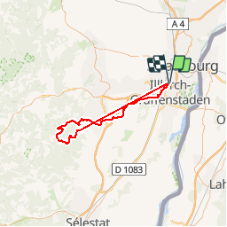
Ruta Bici de carretera de 74 km a descubrir en Gran Este, Bajo-Rin, Ostwald. Esta ruta ha sido propuesta por 26051010.
Descripción
Sortie - mixte VTT- Velo route
Ostwald - Sainte-Odile
Départ Ostwald - Geispolsheim - Blaesheim-
Obernai- Ottrott- D 426 vorbruck
A maison forestière Vorbruck
Les VTT prennent à droite et les
Vélo route à gauche sur la DP 426
Au Sainte-Odile ont se retrouvent
Pour ST Jacques - direction Ottrott ST Nabor
Piste sur Rosheim- Innenheim - Blaesheim
Geispolsheim- Ostwald
Localización
Comentarios
Excursiones cerca
![Excursión Senderismo Estrasburgo - Strasbourg - Centre historique - Photo](https://media.geolcdn.com/t/375/260/ext.jpg?maxdim=2&url=https%3A%2F%2Fservices.sitytrail.com%2FGeolivesWS%2FDownloadMedia.ashx%3FTrailID%3D714530%26Media%3Dfix__20170315162311.jpg)
![Senderismo Senderismo](https://static1.geolcdn.com/sitytour/trail-icons/101.png)
Senderismo
![](/images/other/stat-length.png)
![](https://static1.geolcdn.com/siteimages/upload/files/16400158638029165_repeat_loop_refresh_sync_direction_icon.png)
![Excursión Senderismo Estrasburgo - Untitled - Photo](https://media.geolcdn.com/t/375/260/ext.jpg?maxdim=2&url=https%3A%2F%2Fservices.sitytrail.com%2FGeolivesWS%2FDownloadMedia.ashx%3FTrailID%3D378325%26Media%3D20150118104613.jpg)
![Senderismo Senderismo](https://static1.geolcdn.com/sitytour/trail-icons/101.png)
Senderismo
![](/images/other/stat-length.png)
![](https://static1.geolcdn.com/siteimages/upload/files/16400158638029165_repeat_loop_refresh_sync_direction_icon.png)
![Excursión Senderismo Estrasburgo - Strasbourg Krutenau Université - Photo](https://media.geolcdn.com/t/375/260/8cbb56df-c20b-4a21-8b38-d84143e8ba5e.jpg&format=jpg&maxdim=2)
![Senderismo Senderismo](https://static1.geolcdn.com/sitytour/trail-icons/101.png)
Senderismo
![](/images/other/stat-length.png)
![](https://static1.geolcdn.com/siteimages/upload/files/16400158638029165_repeat_loop_refresh_sync_direction_icon.png)
![Excursión sport Wolfisheim - 20241213 Wolfisheim - Photo](https://media.geolcdn.com/t/375/260/b82d77db-7d71-4ee9-aaab-c2a4d356d4d1.jpg&format=jpg&maxdim=2)
sport
![](/images/other/stat-length.png)
![](https://static1.geolcdn.com/siteimages/upload/files/16400158638029165_repeat_loop_refresh_sync_direction_icon.png)
![Excursión Senderismo Ostwald - Tayla - Photo](https://media.geolcdn.com/t/375/260/236e4d72-747b-45d2-ae4f-84e3c8bc8c57.jpg&format=jpg&maxdim=2)
![Senderismo Senderismo](https://static1.geolcdn.com/sitytour/trail-icons/101.png)
![Excursión Senderismo Ostwald - Lundi - Photo](https://media.geolcdn.com/t/375/260/7f259d80-50fa-422a-96ef-cd2ae8fbda1c.jpg&format=jpg&maxdim=2)
![Senderismo Senderismo](https://static1.geolcdn.com/sitytour/trail-icons/101.png)
![Excursión Bici eléctrica Ostwald - Promenade Vosges - Photo](https://media.geolcdn.com/t/375/260/f9c256ef-dfcd-431d-8977-ca099c8aa398.jpg&format=jpg&maxdim=2)
![Bici eléctrica Bici eléctrica](https://static1.geolcdn.com/sitytour/trail-icons/205.png)
Bici eléctrica
![](/images/other/stat-length.png)
![](https://static1.geolcdn.com/siteimages/upload/files/16400158638029165_repeat_loop_refresh_sync_direction_icon.png)
![Excursión Bici eléctrica Ostwald - Nideck carrefour des Pandours - Photo](https://media.geolcdn.com/t/375/260/e2ea2c89-1b62-4f65-a986-fc596c752bcf.jpg&format=jpg&maxdim=2)
![Bici eléctrica Bici eléctrica](https://static1.geolcdn.com/sitytour/trail-icons/205.png)
Bici eléctrica
![](/images/other/stat-length.png)
![](https://static1.geolcdn.com/siteimages/upload/files/16400158638029165_repeat_loop_refresh_sync_direction_icon.png)
![Excursión Bici de montaña Ostwald - Ostwald Etang du loup - Photo](https://media.geolcdn.com/t/375/260/b25b355f-15e8-48e3-8757-005d4424f736.jpg&format=jpg&maxdim=2)
![Bici de montaña Bici de montaña](https://static1.geolcdn.com/sitytour/trail-icons/202.png)
Bici de montaña
![](/images/other/stat-length.png)
![](https://static1.geolcdn.com/siteimages/upload/files/16400158638029165_repeat_loop_refresh_sync_direction_icon.png)