![](/images/other/stat-length.png)
![Excursión Senderismo Lavaldens - Le Lac de Rif Bruyant - Photo](https://media.geolcdn.com/t/1900/400/43400b67-7253-4e6a-b9f6-12e2b4ba8b46.jpg&format=pjpeg&maxdim=2)
Le Lac de Rif Bruyant
patjobou
Usuario
![Longitud](/images/other/stat-length.png)
Longitud
14 km
![Altitud máxima](https://static1.geolcdn.com/siteimages/upload/files/1508320355ic_sort_altitude_max_24dp.png)
Altitud máxima
2037 m
![Desnivel positivo](https://static1.geolcdn.com/siteimages/upload/files/1508320355ic_sort_den_pos_24dp.png)
Desnivel positivo
1054 m
![Km-Effort](/images/other/stat-length.png)
Km-Effort
28 km
![Altitud mínima](https://static1.geolcdn.com/siteimages/upload/files/1508320355ic_sort_altitude_min_24dp.png)
Altitud mínima
979 m
![Desnivel negativo](https://static1.geolcdn.com/siteimages/upload/files/1508320355ic_sort_den_neg_24dp.png)
Desnivel negativo
1054 m
![Boucle](https://static1.geolcdn.com/siteimages/upload/files/16400158638029165_repeat_loop_refresh_sync_direction_icon.png)
Boucle
Sí
Fecha de creación :
2019-09-19 07:03:38.77
Última modificación :
2019-09-19 19:16:33.576
![Senderismo](https://static1.geolcdn.com/sitytour/trail-icons/101.png)
6h22
Dificultad : Difícil
![Escanee este código QR para abrir la excursión en la aplicación SityTrail](https://capi.geolives.com/qq0zvz2zws4bq2lad0pu/sitytour/trails/2208912/qr.png?size=200)
Aplicación GPS de excursión GRATIS
A propósito
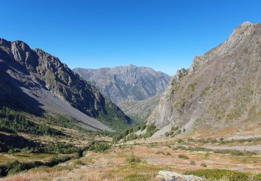
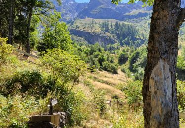
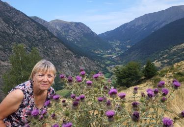
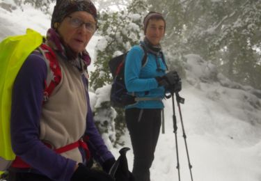
Ruta Senderismo de 14 km a descubrir en Auvergne-Rhône-Alpes, Isère, Lavaldens. Esta ruta ha sido propuesta por patjobou.
Descripción
Belle boucle partielle dans des paysages très variés et sauvages. Peut se faire dans les deux sens, mais dans ce sens on profite de bons lacets pour la montée.
Localización
País:
France
Región :
Auvergne-Rhône-Alpes
Departamento/provincia :
Isère
Municipio :
Lavaldens
Localidad:
Unknown
Salida:(Dec)
Salida:(UTM)
726635 ; 4982675 (31T) N.
Comentarios
Excursiones cerca
![Excursión Senderismo Lavaldens - Le Mollard - Lac Rif Bruyant 01/10/2023 - Photo](https://media.geolcdn.com/t/375/260/19c40cca-c1c5-4cd2-837c-cfeae0558b05.jpg&format=jpg&maxdim=2)
![Senderismo Senderismo](https://static1.geolcdn.com/sitytour/trail-icons/101.png)
Le Mollard - Lac Rif Bruyant 01/10/2023
Senderismo
Muy difícil
Lavaldens,
Auvergne-Rhône-Alpes,
Isère,
France
![](/images/other/stat-length.png)
13,1 km | 27 km-effort
6h 5min
![](https://static1.geolcdn.com/siteimages/upload/files/16400158638029165_repeat_loop_refresh_sync_direction_icon.png)
Sí
![Excursión Senderismo Lavaldens - 2022-07-20_17h08m14_Rif Bruyant - Photo](https://media.geolcdn.com/t/375/260/ext.jpg?maxdim=2&url=https%3A%2F%2Fstatic1.geolcdn.com%2Fsiteimages%2Fupload%2Ffiles%2F1553511878bg_sport_marche.png)
![Senderismo Senderismo](https://static1.geolcdn.com/sitytour/trail-icons/101.png)
2022-07-20_17h08m14_Rif Bruyant
Senderismo
Difícil
(1)
Lavaldens,
Auvergne-Rhône-Alpes,
Isère,
France
![](/images/other/stat-length.png)
13,6 km | 27 km-effort
6h 14min
![](https://static1.geolcdn.com/siteimages/upload/files/16400158638029165_repeat_loop_refresh_sync_direction_icon.png)
Sí
![Excursión Esquí de fondo Saint-Honoré - Le perollier, le Grand Serre - Photo](https://media.geolcdn.com/t/375/260/8f028379-4012-403e-a754-1ba5ea0046bf.jpg&format=jpg&maxdim=2)
![Esquí de fondo Esquí de fondo](https://static1.geolcdn.com/sitytour/trail-icons/503.png)
Le perollier, le Grand Serre
Esquí de fondo
Medio
Saint-Honoré,
Auvergne-Rhône-Alpes,
Isère,
France
![](/images/other/stat-length.png)
15,4 km | 33 km-effort
6h 29min
![](https://static1.geolcdn.com/siteimages/upload/files/16400158638029165_repeat_loop_refresh_sync_direction_icon.png)
Sí
![Excursión Esquí de fondo Saint-Honoré - Tabor de la Mûre - Photo](https://media.geolcdn.com/t/375/260/20d14802-7ff5-4d88-956a-7b9a995b765e.jpg&format=jpg&maxdim=2)
![Esquí de fondo Esquí de fondo](https://static1.geolcdn.com/sitytour/trail-icons/503.png)
Tabor de la Mûre
Esquí de fondo
Fácil
Saint-Honoré,
Auvergne-Rhône-Alpes,
Isère,
France
![](/images/other/stat-length.png)
10,7 km | 24 km-effort
5h 8min
![](https://static1.geolcdn.com/siteimages/upload/files/16400158638029165_repeat_loop_refresh_sync_direction_icon.png)
Sí
![Excursión Senderismo Lavaldens - Rif Bruyant - Photo](https://media.geolcdn.com/t/375/260/8dcecefd-d7fb-4568-9f12-c9e9cddea53d.jpg&format=jpg&maxdim=2)
![Senderismo Senderismo](https://static1.geolcdn.com/sitytour/trail-icons/101.png)
Rif Bruyant
Senderismo
Difícil
Lavaldens,
Auvergne-Rhône-Alpes,
Isère,
France
![](/images/other/stat-length.png)
8,1 km | 16,2 km-effort
4h 21min
![](https://static1.geolcdn.com/siteimages/upload/files/16400158638029165_repeat_loop_refresh_sync_direction_icon.png)
No
![Excursión Senderismo Lavaldens - Lavaldens 400 + - Photo](https://media.geolcdn.com/t/375/260/45b87e76-5e2f-44a8-8782-86a98ed8c427.jpg&format=jpg&maxdim=2)
![Senderismo Senderismo](https://static1.geolcdn.com/sitytour/trail-icons/101.png)
Lavaldens 400 +
Senderismo
Muy difícil
Lavaldens,
Auvergne-Rhône-Alpes,
Isère,
France
![](/images/other/stat-length.png)
23 km | 51 km-effort
2h 25min
![](https://static1.geolcdn.com/siteimages/upload/files/16400158638029165_repeat_loop_refresh_sync_direction_icon.png)
No
![Excursión Senderismo Saint-Honoré - Le Grand Serre - Photo](https://media.geolcdn.com/t/375/260/ea564edc-db3e-467a-9f34-8236705096bb.jpg&format=jpg&maxdim=2)
![Senderismo Senderismo](https://static1.geolcdn.com/sitytour/trail-icons/101.png)
Le Grand Serre
Senderismo
Difícil
Saint-Honoré,
Auvergne-Rhône-Alpes,
Isère,
France
![](/images/other/stat-length.png)
13,1 km | 23 km-effort
6h 0min
![](https://static1.geolcdn.com/siteimages/upload/files/16400158638029165_repeat_loop_refresh_sync_direction_icon.png)
Sí
![Excursión Senderismo La Valette - La cabane de Poyet en circuit - Photo](https://media.geolcdn.com/t/375/260/5619e671-6185-4bcc-8e40-810ed807016c.jpg&format=jpg&maxdim=2)
![Senderismo Senderismo](https://static1.geolcdn.com/sitytour/trail-icons/101.png)
La cabane de Poyet en circuit
Senderismo
Medio
La Valette,
Auvergne-Rhône-Alpes,
Isère,
France
![](/images/other/stat-length.png)
9,1 km | 17,8 km-effort
4h 17min
![](https://static1.geolcdn.com/siteimages/upload/files/16400158638029165_repeat_loop_refresh_sync_direction_icon.png)
Sí
![Excursión Senderismo La Valette - Cabane ONF du Poyet, depuis la Valette - Photo](https://media.geolcdn.com/t/375/260/93222bd8-8947-41da-825b-3739799a19df.jpg&format=jpg&maxdim=2)
![Senderismo Senderismo](https://static1.geolcdn.com/sitytour/trail-icons/101.png)
Cabane ONF du Poyet, depuis la Valette
Senderismo
Medio
La Valette,
Auvergne-Rhône-Alpes,
Isère,
France
![](/images/other/stat-length.png)
10,1 km | 19,5 km-effort
2h 40min
![](https://static1.geolcdn.com/siteimages/upload/files/16400158638029165_repeat_loop_refresh_sync_direction_icon.png)
Sí