![](/images/other/stat-length.png)
![Excursión Senderismo Ligerz - Gléresse - Les moulins - Gorges de Twann - Photo](https://media.geolcdn.com/t/1900/400/ext.pjpeg?maxdim=2&url=https%3A%2F%2Fstatic1.geolcdn.com%2Fsiteimages%2Fupload%2Ffiles%2F1553511878bg_sport_marche.png)
Gléresse - Les moulins - Gorges de Twann
duamerg
Usuario
![Longitud](/images/other/stat-length.png)
![Altitud máxima](https://static1.geolcdn.com/siteimages/upload/files/1508320355ic_sort_altitude_max_24dp.png)
![Desnivel positivo](https://static1.geolcdn.com/siteimages/upload/files/1508320355ic_sort_den_pos_24dp.png)
![Km-Effort](/images/other/stat-length.png)
![Altitud mínima](https://static1.geolcdn.com/siteimages/upload/files/1508320355ic_sort_altitude_min_24dp.png)
![Desnivel negativo](https://static1.geolcdn.com/siteimages/upload/files/1508320355ic_sort_den_neg_24dp.png)
![Boucle](https://static1.geolcdn.com/siteimages/upload/files/16400158638029165_repeat_loop_refresh_sync_direction_icon.png)
![Senderismo](https://static1.geolcdn.com/sitytour/trail-icons/101.png)
4h09
Dificultad : Medio
![Escanee este código QR para abrir la excursión en la aplicación SityTrail](https://capi.geolives.com/qq0zvz2zws4bq2lad0pu/sitytour/trails/22048/qr.png?size=200)
Aplicación GPS de excursión GRATIS
A propósito
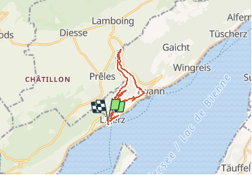
Ruta Senderismo de 11,5 km a descubrir en Berna, Verwaltungskreis Biel/Bienne, Ligerz. Esta ruta ha sido propuesta por duamerg.
Descripción
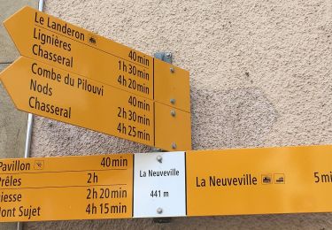
Laisser la voiture au parking couvert (1fr. l'heure). Partir à droite en sortant du parking et monter à l'église (superbe vue). Suivre le parcours mais à la croisée suivante ne pas suivre les marques et continuer tout droit pour arriver à Schernetz. Prendre à gauche à la route et suivre le chemin pédestre. Avant le restaurant partir à droite, après une courte montée on retrouve un chemin fléché. Prendre à gauche et suivre les indications Prêles. Lorsqu'on rejoint la route, ne pas suivre les indications en jaune mais prendre à gauche après une baraque. A la hauteur d'un banc, prendre la route à droite et ne plus la quitter (ne pas prendre une bifurcation à gauche. Belle ballade à l'ombre jusqu'aux Moulins (restaurant). Des Moulins prendre les gorges et suivre les indications pour Gléresse (raccourci - 15mn.)ou continuer jusqu'à la sortie des gorges. Suivre à nouveau Gléresse puis Schernetz (beau banc avec table et vue sur Douanne). Prendre la route qui monte au hameau pour retrouver la route du départ. Cette fois continuer après le restaurant. A la croisée suivante prendre la route qui descend vers l''église. Un peu après l'église se trouve un chemin en escaliers qui mène au charmant village (à visiter). Retour à la voiture.
Localización
Comentarios
Excursiones cerca
![Excursión A pie Twann-Tüscherz - Bielersee Heidenweg - Photo](https://media.geolcdn.com/t/375/260/d073d6a0-d3fc-4691-8384-c343898e7cf3.jpeg&format=jpg&maxdim=2)
![A pie A pie](https://static1.geolcdn.com/sitytour/trail-icons/100.png)
A pie
![](/images/other/stat-length.png)
![](https://static1.geolcdn.com/siteimages/upload/files/16400158638029165_repeat_loop_refresh_sync_direction_icon.png)
![Excursión A pie La Neuveville - La Neuveville - Lignières - Photo](https://media.geolcdn.com/t/375/260/8efce415-6640-430b-a3ed-8ab0638b4b45.jpeg&format=jpg&maxdim=2)
![A pie A pie](https://static1.geolcdn.com/sitytour/trail-icons/100.png)
A pie
![](/images/other/stat-length.png)
![](https://static1.geolcdn.com/siteimages/upload/files/16400158638029165_repeat_loop_refresh_sync_direction_icon.png)
![Excursión A pie Nods - Nods Pierre Grise - Chasseral Hôtel - Photo](https://media.geolcdn.com/t/375/260/d0e46239-22d1-4c02-a179-de1da09817b4.jpeg&format=jpg&maxdim=2)
![A pie A pie](https://static1.geolcdn.com/sitytour/trail-icons/100.png)
A pie
![](/images/other/stat-length.png)
![](https://static1.geolcdn.com/siteimages/upload/files/16400158638029165_repeat_loop_refresh_sync_direction_icon.png)
![Excursión A pie Nods - Nods - Prés Vaillons - Photo](https://media.geolcdn.com/t/375/260/d0e46239-22d1-4c02-a179-de1da09817b4.jpeg&format=jpg&maxdim=2)
![A pie A pie](https://static1.geolcdn.com/sitytour/trail-icons/100.png)
A pie
![](/images/other/stat-length.png)
![](https://static1.geolcdn.com/siteimages/upload/files/16400158638029165_repeat_loop_refresh_sync_direction_icon.png)
![Excursión A pie La Neuveville - Festi - fixme - Photo](https://media.geolcdn.com/t/375/260/1ec500ec-828b-4769-bcce-fdfd731779b5.jpeg&format=jpg&maxdim=2)
![A pie A pie](https://static1.geolcdn.com/sitytour/trail-icons/100.png)
A pie
![](/images/other/stat-length.png)
![](https://static1.geolcdn.com/siteimages/upload/files/16400158638029165_repeat_loop_refresh_sync_direction_icon.png)
![Excursión Senderismo La Neuveville - La Neuveville-Ile de St-Pierre - Photo](https://media.geolcdn.com/t/375/260/ext.jpg?maxdim=2&url=https%3A%2F%2Fstatic1.geolcdn.com%2Fsiteimages%2Fupload%2Ffiles%2F1553511878bg_sport_marche.png)
![Senderismo Senderismo](https://static1.geolcdn.com/sitytour/trail-icons/101.png)
Senderismo
![](/images/other/stat-length.png)
![](https://static1.geolcdn.com/siteimages/upload/files/16400158638029165_repeat_loop_refresh_sync_direction_icon.png)
![Excursión A pie Plateau de Diesse - Lamboing - Pt 1290 - Photo](https://media.geolcdn.com/t/375/260/ec5bef30-d885-47d1-b61b-5de7c329435c.jpeg&format=jpg&maxdim=2)
![A pie A pie](https://static1.geolcdn.com/sitytour/trail-icons/100.png)
A pie
![](/images/other/stat-length.png)
![](https://static1.geolcdn.com/siteimages/upload/files/16400158638029165_repeat_loop_refresh_sync_direction_icon.png)
![Excursión A pie La Neuveville - La Praye - La Neuveville - Photo](https://media.geolcdn.com/t/375/260/ext.jpg?maxdim=2&url=https%3A%2F%2Fstatic1.geolcdn.com%2Fsiteimages%2Fupload%2Ffiles%2F1545311037marcheuse_200dpi.jpg)
![A pie A pie](https://static1.geolcdn.com/sitytour/trail-icons/100.png)
A pie
![](/images/other/stat-length.png)
![](https://static1.geolcdn.com/siteimages/upload/files/16400158638029165_repeat_loop_refresh_sync_direction_icon.png)