![](/images/other/stat-length.png)
![Excursión Senderismo Gex - La Faucille Le Mailly Colomby de Gex - Photo](https://media.geolcdn.com/t/1900/400/ext.pjpeg?maxdim=2&url=https%3A%2F%2Fstatic1.geolcdn.com%2Fsiteimages%2Fupload%2Ffiles%2F1553511878bg_sport_marche.png)
La Faucille Le Mailly Colomby de Gex
HB01
Usuario
![Longitud](/images/other/stat-length.png)
Longitud
18,9 km
![Altitud máxima](https://static1.geolcdn.com/siteimages/upload/files/1508320355ic_sort_altitude_max_24dp.png)
Altitud máxima
1681 m
![Desnivel positivo](https://static1.geolcdn.com/siteimages/upload/files/1508320355ic_sort_den_pos_24dp.png)
Desnivel positivo
940 m
![Km-Effort](/images/other/stat-length.png)
Km-Effort
31 km
![Altitud mínima](https://static1.geolcdn.com/siteimages/upload/files/1508320355ic_sort_altitude_min_24dp.png)
Altitud mínima
1150 m
![Desnivel negativo](https://static1.geolcdn.com/siteimages/upload/files/1508320355ic_sort_den_neg_24dp.png)
Desnivel negativo
940 m
![Boucle](https://static1.geolcdn.com/siteimages/upload/files/16400158638029165_repeat_loop_refresh_sync_direction_icon.png)
Boucle
Sí
Fecha de creación :
2019-09-14 08:04:04.316
Última modificación :
2019-09-14 16:40:48.569
![Senderismo](https://static1.geolcdn.com/sitytour/trail-icons/101.png)
6h25
Dificultad : Medio
![Escanee este código QR para abrir la excursión en la aplicación SityTrail](https://capi.geolives.com/qq0zvz2zws4bq2lad0pu/sitytour/trails/2202240/qr.png?size=200)
Aplicación GPS de excursión GRATIS
A propósito
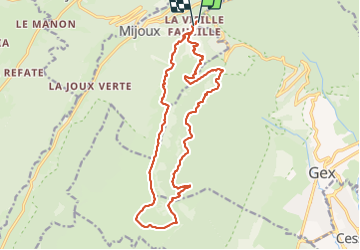
Ruta Senderismo de 18,9 km a descubrir en Auvergne-Rhône-Alpes, Ain, Gex. Esta ruta ha sido propuesta por HB01.
Descripción
Départ La Faucille Petit Mont Rond Le Pailly Comby de Gex Crêtes La Faucille
du 15 Mai au 1er Décembre. fortes pentes
Localización
País:
France
Región :
Auvergne-Rhône-Alpes
Departamento/provincia :
Ain
Municipio :
Gex
Localidad:
Unknown
Salida:(Dec)
Salida:(UTM)
270529 ; 5139304 (32T) N.
Comentarios
Excursiones cerca
![Excursión Senderismo Lamoura - Tresberruy - Lamoura - Photo](https://media.geolcdn.com/t/375/260/ext.jpg?maxdim=2&url=https%3A%2F%2Fservices.sitytrail.com%2FGeolivesWS%2FDownloadMedia.ashx%3FTrailID%3D191503%26Media%3D15097_5.jpg)
![Senderismo Senderismo](https://static1.geolcdn.com/sitytour/trail-icons/101.png)
Tresberruy - Lamoura
Senderismo
Difícil
(1)
Lamoura,
Borgoña-Franco Condado,
Jura,
France
![](/images/other/stat-length.png)
14,5 km | 20 km-effort
4h 0min
![](https://static1.geolcdn.com/siteimages/upload/files/16400158638029165_repeat_loop_refresh_sync_direction_icon.png)
Sí
![Excursión Bicicleta Lajoux - 2023-08-18_15h23m20_lamoura - Photo](https://media.geolcdn.com/t/375/260/ext.jpg?maxdim=2&url=https%3A%2F%2Fstatic1.geolcdn.com%2Fsiteimages%2Fupload%2Ffiles%2F1524743154velo.jpg)
![Bicicleta Bicicleta](https://static1.geolcdn.com/sitytour/trail-icons/200.png)
2023-08-18_15h23m20_lamoura
Bicicleta
Muy fácil
(1)
Lajoux,
Borgoña-Franco Condado,
Jura,
France
![](/images/other/stat-length.png)
21 km | 26 km-effort
Desconocido
![](https://static1.geolcdn.com/siteimages/upload/files/16400158638029165_repeat_loop_refresh_sync_direction_icon.png)
Sí
![Excursión Carrera Mijoux - UTTJ 2015-2 - Photo](https://media.geolcdn.com/t/375/260/ext.jpg?maxdim=2&url=https%3A%2F%2Fstatic1.geolcdn.com%2Fsiteimages%2Fupload%2Ffiles%2F1524743154running.jpg)
![Carrera Carrera](https://static1.geolcdn.com/sitytour/trail-icons/103.png)
UTTJ 2015-2
Carrera
Muy difícil
(1)
Mijoux,
Auvergne-Rhône-Alpes,
Ain,
France
![](/images/other/stat-length.png)
57 km | 92 km-effort
18h 13min
![](https://static1.geolcdn.com/siteimages/upload/files/16400158638029165_repeat_loop_refresh_sync_direction_icon.png)
No
![Excursión Senderismo Lamoura - lamoura neige et plein air - Photo](https://media.geolcdn.com/t/375/260/79eb4e53-0429-41e7-9bcb-cf15e9d8ead1.jpg&format=jpg&maxdim=2)
![Senderismo Senderismo](https://static1.geolcdn.com/sitytour/trail-icons/101.png)
lamoura neige et plein air
Senderismo
Difícil
Lamoura,
Borgoña-Franco Condado,
Jura,
France
![](/images/other/stat-length.png)
6,8 km | 9,5 km-effort
2h 25min
![](https://static1.geolcdn.com/siteimages/upload/files/16400158638029165_repeat_loop_refresh_sync_direction_icon.png)
Sí
![Excursión Senderismo Lamoura - neige et plein air lamoura - Photo](https://media.geolcdn.com/t/375/260/0b5e943d-bb9b-41cd-9490-d26e61edcd49.jpg&format=jpg&maxdim=2)
![Senderismo Senderismo](https://static1.geolcdn.com/sitytour/trail-icons/101.png)
neige et plein air lamoura
Senderismo
Medio
Lamoura,
Borgoña-Franco Condado,
Jura,
France
![](/images/other/stat-length.png)
6,8 km | 9,3 km-effort
2h 54min
![](https://static1.geolcdn.com/siteimages/upload/files/16400158638029165_repeat_loop_refresh_sync_direction_icon.png)
Sí
![Excursión Senderismo Lajoux - Le crêt de la vigoureuse (le vrai) - Photo](https://media.geolcdn.com/t/375/260/5ee095a6-7dfc-4756-a886-0e730cf92336.jpg&format=jpg&maxdim=2)
![Senderismo Senderismo](https://static1.geolcdn.com/sitytour/trail-icons/101.png)
Le crêt de la vigoureuse (le vrai)
Senderismo
Fácil
Lajoux,
Borgoña-Franco Condado,
Jura,
France
![](/images/other/stat-length.png)
10,4 km | 13,4 km-effort
4h 9min
![](https://static1.geolcdn.com/siteimages/upload/files/16400158638029165_repeat_loop_refresh_sync_direction_icon.png)
Sí
![Excursión Senderismo Lajoux - crêt vigoureuse - Photo](https://media.geolcdn.com/t/375/260/621ceada-b70a-4736-ab71-b2ed77e63872.jpg&format=jpg&maxdim=2)
![Senderismo Senderismo](https://static1.geolcdn.com/sitytour/trail-icons/101.png)
crêt vigoureuse
Senderismo
Medio
Lajoux,
Borgoña-Franco Condado,
Jura,
France
![](/images/other/stat-length.png)
12,3 km | 16,8 km-effort
5h 0min
![](https://static1.geolcdn.com/siteimages/upload/files/16400158638029165_repeat_loop_refresh_sync_direction_icon.png)
Sí
![Excursión Senderismo Gex - Balade à Col de la Faucille, Gex - Photo](https://media.geolcdn.com/t/375/260/2f44fa08-e5b7-4e3a-aeb8-a26203de0478.jpg&format=jpg&maxdim=2)
![Senderismo Senderismo](https://static1.geolcdn.com/sitytour/trail-icons/101.png)
Balade à Col de la Faucille, Gex
Senderismo
Muy difícil
Gex,
Auvergne-Rhône-Alpes,
Ain,
France
![](/images/other/stat-length.png)
86 km | 135 km-effort
9h 23min
![](https://static1.geolcdn.com/siteimages/upload/files/16400158638029165_repeat_loop_refresh_sync_direction_icon.png)
No
![Excursión Cicloturismo Mijoux - LES ROUSSES - COL DE LA FAUCILLE - Photo](https://media.geolcdn.com/t/375/260/8bcbda14-9a90-4870-91bc-b4b02ae26659.jpg&format=jpg&maxdim=2)
![Cicloturismo Cicloturismo](https://static1.geolcdn.com/sitytour/trail-icons/204.png)
LES ROUSSES - COL DE LA FAUCILLE
Cicloturismo
Muy difícil
Mijoux,
Auvergne-Rhône-Alpes,
Ain,
France
![](/images/other/stat-length.png)
54 km | 68 km-effort
4h 57min
![](https://static1.geolcdn.com/siteimages/upload/files/16400158638029165_repeat_loop_refresh_sync_direction_icon.png)
No