![](/images/other/stat-length.png)
![Excursión Senderismo Masevaux-Niederbruck - Source de la Doller - Photo](https://media.geolcdn.com/t/1900/400/ext.pjpeg?maxdim=2&url=https%3A%2F%2Fstatic1.geolcdn.com%2Fsiteimages%2Fupload%2Ffiles%2F1553511878bg_sport_marche.png)
Source de la Doller
regisbodilis
Usuario
![Longitud](/images/other/stat-length.png)
Longitud
8,6 km
![Altitud máxima](https://static1.geolcdn.com/siteimages/upload/files/1508320355ic_sort_altitude_max_24dp.png)
Altitud máxima
902 m
![Desnivel positivo](https://static1.geolcdn.com/siteimages/upload/files/1508320355ic_sort_den_pos_24dp.png)
Desnivel positivo
602 m
![Km-Effort](/images/other/stat-length.png)
Km-Effort
15,1 km
![Altitud mínima](https://static1.geolcdn.com/siteimages/upload/files/1508320355ic_sort_altitude_min_24dp.png)
Altitud mínima
452 m
![Desnivel negativo](https://static1.geolcdn.com/siteimages/upload/files/1508320355ic_sort_den_neg_24dp.png)
Desnivel negativo
159 m
![Boucle](https://static1.geolcdn.com/siteimages/upload/files/16400158638029165_repeat_loop_refresh_sync_direction_icon.png)
Boucle
No
Fecha de creación :
2014-12-10 00:00:00.0
Última modificación :
2014-12-10 00:00:00.0
![Senderismo](https://static1.geolcdn.com/sitytour/trail-icons/101.png)
3h27
Dificultad : Medio
![Escanee este código QR para abrir la excursión en la aplicación SityTrail](https://capi.geolives.com/qq0zvz2zws4bq2lad0pu/sitytour/trails/219467/qr.png?size=200)
Aplicación GPS de excursión GRATIS
A propósito
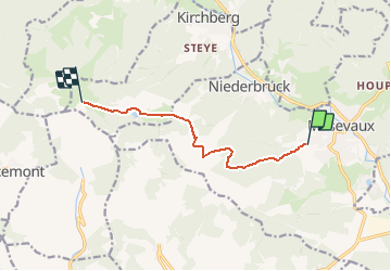
Ruta Senderismo de 8,6 km a descubrir en Gran Este, Alto Rin, Masevaux-Niederbruck. Esta ruta ha sido propuesta por regisbodilis.
Descripción
Stoeckeim - GR531 (rect. bleu ciel) - FA Bruckenwald - Lac Lachtehweiler - FA Lochberg - Retour à Stoecken
Localización
País:
France
Región :
Gran Este
Departamento/provincia :
Alto Rin
Municipio :
Masevaux-Niederbruck
Localidad:
Masevaux
Salida:(Dec)
Salida:(UTM)
349037 ; 5292795 (32T) N.
Comentarios
Excursiones cerca
![Excursión Senderismo Masevaux-Niederbruck - Masevaux - Rossberg par le belvédère du Fuchsfelsen - Photo](https://media.geolcdn.com/t/375/260/d9cc765c-1250-4953-9d9f-fb8b88eb82a7.jpg&format=jpg&maxdim=2)
![Senderismo Senderismo](https://static1.geolcdn.com/sitytour/trail-icons/101.png)
Masevaux - Rossberg par le belvédère du Fuchsfelsen
Senderismo
Medio
(1)
Masevaux-Niederbruck,
Gran Este,
Alto Rin,
France
![](/images/other/stat-length.png)
19,9 km | 34 km-effort
4h 44min
![](https://static1.geolcdn.com/siteimages/upload/files/16400158638029165_repeat_loop_refresh_sync_direction_icon.png)
Sí
![Excursión Senderismo Sentheim - Sentheim Rossberg - Photo](https://media.geolcdn.com/t/375/260/a036ff16-f534-44a4-ad7d-39598edf8c1e.jpg&format=jpg&maxdim=2)
![Senderismo Senderismo](https://static1.geolcdn.com/sitytour/trail-icons/101.png)
Sentheim Rossberg
Senderismo
Medio
(1)
Sentheim,
Gran Este,
Alto Rin,
France
![](/images/other/stat-length.png)
27 km | 40 km-effort
6h 11min
![](https://static1.geolcdn.com/siteimages/upload/files/16400158638029165_repeat_loop_refresh_sync_direction_icon.png)
Sí
![Excursión Senderismo Dolleren - suuntoapp-Hiking-2025-01-02T19-20-24Z - Photo](https://media.geolcdn.com/t/375/260/98b6c1e4-75f0-464a-86a1-edc427e75210.jpg&format=jpg&maxdim=2)
![Senderismo Senderismo](https://static1.geolcdn.com/sitytour/trail-icons/101.png)
suuntoapp-Hiking-2025-01-02T19-20-24Z
Senderismo
Medio
Dolleren,
Gran Este,
Alto Rin,
France
![](/images/other/stat-length.png)
4,3 km | 8,1 km-effort
1h 50min
![](https://static1.geolcdn.com/siteimages/upload/files/16400158638029165_repeat_loop_refresh_sync_direction_icon.png)
No
![Excursión Senderismo Bourbach-le-Haut - 2024-01-12_14h17m14_239006910 - Photo](https://media.geolcdn.com/t/375/260/d4089ace-97e6-4d95-86a3-a999ece263d3.jpg&format=jpg&maxdim=2)
![Senderismo Senderismo](https://static1.geolcdn.com/sitytour/trail-icons/101.png)
2024-01-12_14h17m14_239006910
Senderismo
Difícil
Bourbach-le-Haut,
Gran Este,
Alto Rin,
France
![](/images/other/stat-length.png)
11,4 km | 18,5 km-effort
4h 12min
![](https://static1.geolcdn.com/siteimages/upload/files/16400158638029165_repeat_loop_refresh_sync_direction_icon.png)
Sí
![Excursión Senderismo Kirchberg - 2022-07-15 Marche Refuge Baerenkopf Auberge Gazon Vert - Photo](https://media.geolcdn.com/t/375/260/d5c191fc-95a3-4bb1-8368-e694339cee76.jpg&format=jpg&maxdim=2)
![Senderismo Senderismo](https://static1.geolcdn.com/sitytour/trail-icons/101.png)
2022-07-15 Marche Refuge Baerenkopf Auberge Gazon Vert
Senderismo
Muy difícil
Kirchberg,
Gran Este,
Alto Rin,
France
![](/images/other/stat-length.png)
23 km | 38 km-effort
8h 21min
![](https://static1.geolcdn.com/siteimages/upload/files/16400158638029165_repeat_loop_refresh_sync_direction_icon.png)
No
![Excursión Senderismo Lauw - 2022-07-14 Marche Lauw Refuge CAF Baerenkopf - Photo](https://media.geolcdn.com/t/375/260/e2209d17-65ac-46f6-a404-5274e10a843e.jpg&format=jpg&maxdim=2)
![Senderismo Senderismo](https://static1.geolcdn.com/sitytour/trail-icons/101.png)
2022-07-14 Marche Lauw Refuge CAF Baerenkopf
Senderismo
Muy difícil
Lauw,
Gran Este,
Alto Rin,
France
![](/images/other/stat-length.png)
18,4 km | 31 km-effort
5h 35min
![](https://static1.geolcdn.com/siteimages/upload/files/16400158638029165_repeat_loop_refresh_sync_direction_icon.png)
No
![Excursión A pie Sentheim - Sentier géologique du Wolfloch - Photo](https://media.geolcdn.com/t/375/260/3b31644e-e98b-4e9b-958d-a3c4208c2bbd.jpeg&format=jpg&maxdim=2)
![A pie A pie](https://static1.geolcdn.com/sitytour/trail-icons/100.png)
Sentier géologique du Wolfloch
A pie
Fácil
Sentheim,
Gran Este,
Alto Rin,
France
![](/images/other/stat-length.png)
3,8 km | 4,8 km-effort
1h 5min
![](https://static1.geolcdn.com/siteimages/upload/files/16400158638029165_repeat_loop_refresh_sync_direction_icon.png)
No
![Excursión A pie Sentheim - Sentheim - Bergwald - Eichwald - Guevenheim - Sentheim - Photo](https://media.geolcdn.com/t/375/260/ext.jpg?maxdim=2&url=https%3A%2F%2Fstatic1.geolcdn.com%2Fsiteimages%2Fupload%2Ffiles%2F1545311037marcheuse_200dpi.jpg)
![A pie A pie](https://static1.geolcdn.com/sitytour/trail-icons/100.png)
Sentheim - Bergwald - Eichwald - Guevenheim - Sentheim
A pie
Fácil
(1)
Sentheim,
Gran Este,
Alto Rin,
France
![](/images/other/stat-length.png)
13,4 km | 16,6 km-effort
Desconocido
![](https://static1.geolcdn.com/siteimages/upload/files/16400158638029165_repeat_loop_refresh_sync_direction_icon.png)
Sí
![Excursión Senderismo Bitschwiller-lès-Thann - 68 Col du Hundsrück - FA Gsang - retour ThannerHubel - Photo](https://media.geolcdn.com/t/375/260/ext.jpg?maxdim=2&url=https%3A%2F%2Fstatic1.geolcdn.com%2Fsiteimages%2Fupload%2Ffiles%2F1553511878bg_sport_marche.png)
![Senderismo Senderismo](https://static1.geolcdn.com/sitytour/trail-icons/101.png)
68 Col du Hundsrück - FA Gsang - retour ThannerHubel
Senderismo
Medio
(1)
Bitschwiller-lès-Thann,
Gran Este,
Alto Rin,
France
![](/images/other/stat-length.png)
11,2 km | 18,4 km-effort
3h 48min
![](https://static1.geolcdn.com/siteimages/upload/files/16400158638029165_repeat_loop_refresh_sync_direction_icon.png)
Sí