![](/images/other/stat-length.png)
![Excursión Senderismo Mont-Élie - Mont des Morios - Photo](https://media.geolcdn.com/t/1900/400/ext.pjpeg?maxdim=2&url=https%3A%2F%2Fstatic1.geolcdn.com%2Fsiteimages%2Fupload%2Ffiles%2F1553511878bg_sport_marche.png)
Mont des Morios
Alizée.pee
Usuario GUIDE
![Longitud](/images/other/stat-length.png)
Longitud
12 km
![Altitud máxima](https://static1.geolcdn.com/siteimages/upload/files/1508320355ic_sort_altitude_max_24dp.png)
Altitud máxima
935 m
![Desnivel positivo](https://static1.geolcdn.com/siteimages/upload/files/1508320355ic_sort_den_pos_24dp.png)
Desnivel positivo
655 m
![Km-Effort](/images/other/stat-length.png)
Km-Effort
21 km
![Altitud mínima](https://static1.geolcdn.com/siteimages/upload/files/1508320355ic_sort_altitude_min_24dp.png)
Altitud mínima
352 m
![Desnivel negativo](https://static1.geolcdn.com/siteimages/upload/files/1508320355ic_sort_den_neg_24dp.png)
Desnivel negativo
655 m
![Boucle](https://static1.geolcdn.com/siteimages/upload/files/16400158638029165_repeat_loop_refresh_sync_direction_icon.png)
Boucle
Sí
Fecha de creación :
2019-09-06 13:15:26.063
Última modificación :
2019-09-06 13:16:18.47
![Senderismo](https://static1.geolcdn.com/sitytour/trail-icons/101.png)
4h12
Dificultad : Difícil
![Escanee este código QR para abrir la excursión en la aplicación SityTrail](https://capi.geolives.com/qq0zvz2zws4bq2lad0pu/sitytour/trails/2193343/qr.png?size=200)
Aplicación GPS de excursión GRATIS
A propósito
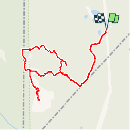
Ruta Senderismo de 12 km a descubrir en Quebec, Charlevoix-Est, Mont-Élie. Esta ruta ha sido propuesta por Alizée.pee.
Descripción
Randonnée difficile, pour expert. Il faut avoir un minimum de technique. La vue est incroyable avec des panoramas à couper le souffle. Le sentier est bien marqué et pratique à suivre. Difficile mais il en vaut la peine.
Localización
País:
Canada
Región :
Quebec
Departamento/provincia :
Charlevoix-Est
Municipio :
Mont-Élie
Localidad:
Unknown
Salida:(Dec)
Salida:(UTM)
387467 ; 5288775 (19T) N.
Comentarios
Excursiones cerca
![Excursión Senderismo Mont-Élie - Trail Planner Map - Photo](https://media.geolcdn.com/t/375/260/ext.jpg?maxdim=2&url=https%3A%2F%2Fstatic1.geolcdn.com%2Fsiteimages%2Fupload%2Ffiles%2F1553511878bg_sport_marche.png)
![Senderismo Senderismo](https://static1.geolcdn.com/sitytour/trail-icons/101.png)
Trail Planner Map
Senderismo
Difícil
Mont-Élie,
Quebec,
Charlevoix-Est,
Canada
![](/images/other/stat-length.png)
21 km | 28 km-effort
5h 57min
![](https://static1.geolcdn.com/siteimages/upload/files/16400158638029165_repeat_loop_refresh_sync_direction_icon.png)
Sí
![Excursión Senderismo Lac-Pikauba - Trail Planner Map - Photo](https://media.geolcdn.com/t/375/260/ext.jpg?maxdim=2&url=https%3A%2F%2Fstatic1.geolcdn.com%2Fsiteimages%2Fupload%2Ffiles%2F1553511878bg_sport_marche.png)
![Senderismo Senderismo](https://static1.geolcdn.com/sitytour/trail-icons/101.png)
Trail Planner Map
Senderismo
Fácil
(1)
Lac-Pikauba,
Quebec,
Charlevoix,
Canada
![](/images/other/stat-length.png)
4,7 km | 7,6 km-effort
1h 33min
![](https://static1.geolcdn.com/siteimages/upload/files/16400158638029165_repeat_loop_refresh_sync_direction_icon.png)
Sí
![Excursión Bicicleta Lac-Pikauba - Mont du lac a L'Empeche - Photo](https://media.geolcdn.com/t/375/260/ext.jpg?maxdim=2&url=https%3A%2F%2Fstatic1.geolcdn.com%2Fsiteimages%2Fupload%2Ffiles%2F1524743154velo.jpg)
![Bicicleta Bicicleta](https://static1.geolcdn.com/sitytour/trail-icons/200.png)
Mont du lac a L'Empeche
Bicicleta
Medio
Lac-Pikauba,
Quebec,
Charlevoix,
Canada
![](/images/other/stat-length.png)
13,1 km | 21 km-effort
2h 0min
![](https://static1.geolcdn.com/siteimages/upload/files/16400158638029165_repeat_loop_refresh_sync_direction_icon.png)
Sí
![Excursión Senderismo Lac-Pikauba - 2014-10-11 13:54:29 - Photo](https://media.geolcdn.com/t/375/260/ext.jpg?maxdim=2&url=https%3A%2F%2Fstatic1.geolcdn.com%2Fsiteimages%2Fupload%2Ffiles%2F1553511878bg_sport_marche.png)
![Senderismo Senderismo](https://static1.geolcdn.com/sitytour/trail-icons/101.png)
2014-10-11 13:54:29
Senderismo
Fácil
Lac-Pikauba,
Quebec,
Charlevoix,
Canada
![](/images/other/stat-length.png)
7,7 km | 13,1 km-effort
3h 30min
![](https://static1.geolcdn.com/siteimages/upload/files/16400158638029165_repeat_loop_refresh_sync_direction_icon.png)
Sí
![Excursión Senderismo Lac-Pikauba - 10-AUG-13 - Photo](https://media.geolcdn.com/t/375/260/ext.jpg?maxdim=2&url=https%3A%2F%2Fstatic1.geolcdn.com%2Fsiteimages%2Fupload%2Ffiles%2F1553511878bg_sport_marche.png)
![Senderismo Senderismo](https://static1.geolcdn.com/sitytour/trail-icons/101.png)
10-AUG-13
Senderismo
Medio
(1)
Lac-Pikauba,
Quebec,
Charlevoix,
Canada
![](/images/other/stat-length.png)
13,5 km | 22 km-effort
6h 0min
![](https://static1.geolcdn.com/siteimages/upload/files/16400158638029165_repeat_loop_refresh_sync_direction_icon.png)
Sí
![Excursión Senderismo Lac-Pikauba - 12-AUG-13 - Photo](https://media.geolcdn.com/t/375/260/ext.jpg?maxdim=2&url=https%3A%2F%2Fstatic1.geolcdn.com%2Fsiteimages%2Fupload%2Ffiles%2F1553511878bg_sport_marche.png)
![Senderismo Senderismo](https://static1.geolcdn.com/sitytour/trail-icons/101.png)
12-AUG-13
Senderismo
Medio
Lac-Pikauba,
Quebec,
Charlevoix,
Canada
![](/images/other/stat-length.png)
11,4 km | 19,4 km-effort
5h 0min
![](https://static1.geolcdn.com/siteimages/upload/files/16400158638029165_repeat_loop_refresh_sync_direction_icon.png)
Sí
![Excursión Senderismo Mont-Élie - ACTIVE LOG091154 - Photo](https://media.geolcdn.com/t/375/260/ext.jpg?maxdim=2&url=https%3A%2F%2Fstatic1.geolcdn.com%2Fsiteimages%2Fupload%2Ffiles%2F1553511878bg_sport_marche.png)
![Senderismo Senderismo](https://static1.geolcdn.com/sitytour/trail-icons/101.png)
ACTIVE LOG091154
Senderismo
Muy difícil
Mont-Élie,
Quebec,
Charlevoix-Est,
Canada
![](/images/other/stat-length.png)
10,5 km | 22 km-effort
5h 0min
![](https://static1.geolcdn.com/siteimages/upload/files/16400158638029165_repeat_loop_refresh_sync_direction_icon.png)
Sí
![Excursión Senderismo Lac-Pikauba - Wikiloc - Sentier la Chouenne - Parc national des grands jardins - Photo](https://media.geolcdn.com/t/375/260/ext.jpg?maxdim=2&url=https%3A%2F%2Fstatic1.geolcdn.com%2Fsiteimages%2Fupload%2Ffiles%2F1553511878bg_sport_marche.png)
![Senderismo Senderismo](https://static1.geolcdn.com/sitytour/trail-icons/101.png)
Wikiloc - Sentier la Chouenne - Parc national des grands jardins
Senderismo
Medio
(1)
Lac-Pikauba,
Quebec,
Charlevoix,
Canada
![](/images/other/stat-length.png)
4,6 km | 7,5 km-effort
1h 32min
![](https://static1.geolcdn.com/siteimages/upload/files/16400158638029165_repeat_loop_refresh_sync_direction_icon.png)
Sí
![Excursión Senderismo Lac-Pikauba - Wikiloc - Parc National des Grands-Jardins - Sentier Le Pioui. - Photo](https://media.geolcdn.com/t/375/260/ext.jpg?maxdim=2&url=https%3A%2F%2Fstatic1.geolcdn.com%2Fsiteimages%2Fupload%2Ffiles%2F1553511878bg_sport_marche.png)
![Senderismo Senderismo](https://static1.geolcdn.com/sitytour/trail-icons/101.png)
Wikiloc - Parc National des Grands-Jardins - Sentier Le Pioui.
Senderismo
Difícil
(1)
Lac-Pikauba,
Quebec,
Charlevoix,
Canada
![](/images/other/stat-length.png)
10,8 km | 18,7 km-effort
3h 48min
![](https://static1.geolcdn.com/siteimages/upload/files/16400158638029165_repeat_loop_refresh_sync_direction_icon.png)
Sí