![](/images/other/stat-length.png)
![Excursión Senderismo Saint-Étienne-de-Lugdarès - 8- Le sommet des trois seigneurs - Photo](https://media.geolcdn.com/t/1900/400/ext.pjpeg?maxdim=2&url=https%3A%2F%2Fstatic1.geolcdn.com%2Fsiteimages%2Fupload%2Ffiles%2F1553511878bg_sport_marche.png)
8- Le sommet des trois seigneurs
MORLE
Usuario
![Longitud](/images/other/stat-length.png)
![Altitud máxima](https://static1.geolcdn.com/siteimages/upload/files/1508320355ic_sort_altitude_max_24dp.png)
![Desnivel positivo](https://static1.geolcdn.com/siteimages/upload/files/1508320355ic_sort_den_pos_24dp.png)
![Km-Effort](/images/other/stat-length.png)
![Altitud mínima](https://static1.geolcdn.com/siteimages/upload/files/1508320355ic_sort_altitude_min_24dp.png)
![Desnivel negativo](https://static1.geolcdn.com/siteimages/upload/files/1508320355ic_sort_den_neg_24dp.png)
![Boucle](https://static1.geolcdn.com/siteimages/upload/files/16400158638029165_repeat_loop_refresh_sync_direction_icon.png)
![Senderismo](https://static1.geolcdn.com/sitytour/trail-icons/101.png)
4h16
Dificultad : Difícil
![Escanee este código QR para abrir la excursión en la aplicación SityTrail](https://capi.geolives.com/qq0zvz2zws4bq2lad0pu/sitytour/trails/2190770/qr.png?size=200)
Aplicación GPS de excursión GRATIS
A propósito
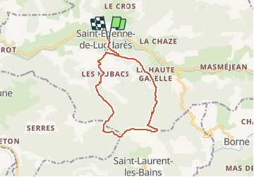
Ruta Senderismo de 13,1 km a descubrir en Auvergne-Rhône-Alpes, Ardecha, Saint-Étienne-de-Lugdarès. Esta ruta ha sido propuesta por MORLE.
Descripción
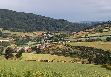
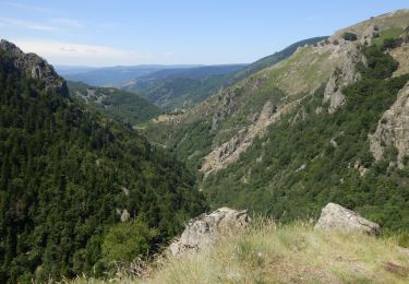
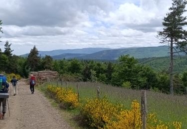
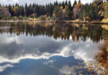
Du village de Saint-Etienne-de-Lugdarès, il est difficile d’imaginer qu’au détour d’un petit col se cachent des vallons cachés, des hameaux reculés, des paysages sauvages à perte de vue. C’est pourtant ce que réserve cette petite virée à la journée.
Au XIV ème siècle, les 3 Seigneurs de la régions, après avoir vaincu les envahisseurs anglais, ont souhaité perpétuer le souvenir de cette éclatante victoire en faisant graver leurs armes sur 3 grandes pierres de granite au sommet des rochers auxquels ils ont donné leurs noms. Des recherches ont été entreprises pour retrouver ces 3 tables perdues, en vain. Aussi, le mystère reste entier quant à la véritable localisation du sommet des 3 Seigneurs.
Certains prétendent qu’il est celui qui culmine à 1363m d’autres celui à 1270m, d’autres encore celui à 1391m... à chacun son sommet !
Localización
Comentarios
Excursiones cerca
![Excursión Senderismo Laveyrune - chemin de Stevenson étape 6 - Photo](https://media.geolcdn.com/t/375/260/03091446-e0a3-452d-a9a6-0e5da8b0e881.jpg&format=jpg&maxdim=2)
![Senderismo Senderismo](https://static1.geolcdn.com/sitytour/trail-icons/101.png)
Senderismo
![](/images/other/stat-length.png)
![](https://static1.geolcdn.com/siteimages/upload/files/16400158638029165_repeat_loop_refresh_sync_direction_icon.png)
![Excursión Senderismo Saint-Laurent-les-Bains-Laval-d'Aurelle - Etape3 Cévenne ardéchoise 17km - Photo](https://media.geolcdn.com/t/375/260/890192a2-9a08-4bfd-b925-e69779af9b69.jpg&format=jpg&maxdim=2)
![Senderismo Senderismo](https://static1.geolcdn.com/sitytour/trail-icons/101.png)
Senderismo
![](/images/other/stat-length.png)
![](https://static1.geolcdn.com/siteimages/upload/files/16400158638029165_repeat_loop_refresh_sync_direction_icon.png)
![Excursión Bici de carretera Saint-Laurent-les-Bains-Laval-d'Aurelle - 07 st Laurent les bains sanilhac largentiere - Photo](https://media.geolcdn.com/t/375/260/4d4a0f3e-2b3e-41e6-8fc5-098ab488c631.jpg&format=jpg&maxdim=2)
![Bici de carretera Bici de carretera](https://static1.geolcdn.com/sitytour/trail-icons/201.png)
Bici de carretera
![](/images/other/stat-length.png)
![](https://static1.geolcdn.com/siteimages/upload/files/16400158638029165_repeat_loop_refresh_sync_direction_icon.png)
![Excursión Senderismo Luc - 5 étape Stevenson - Photo](https://media.geolcdn.com/t/375/260/bce1fbca-ee7b-470a-85b4-41c8101bc81d.jpg&format=jpg&maxdim=2)
![Senderismo Senderismo](https://static1.geolcdn.com/sitytour/trail-icons/101.png)
Senderismo
![](/images/other/stat-length.png)
![](https://static1.geolcdn.com/siteimages/upload/files/16400158638029165_repeat_loop_refresh_sync_direction_icon.png)
![Excursión Senderismo Luc - Une partie du sentier de Stevenson - Photo](https://media.geolcdn.com/t/375/260/bfb9d05e-ae3e-460a-ba5c-c5037b124f03.jpg&format=jpg&maxdim=2)
![Senderismo Senderismo](https://static1.geolcdn.com/sitytour/trail-icons/101.png)
Senderismo
![](/images/other/stat-length.png)
![](https://static1.geolcdn.com/siteimages/upload/files/16400158638029165_repeat_loop_refresh_sync_direction_icon.png)
![Excursión Senderismo Saint-Laurent-les-Bains-Laval-d'Aurelle - 07-TMA-St-Laurent-les-Bains - Montselgues - Photo](https://media.geolcdn.com/t/375/260/6509ff98-7ef9-4350-a2c4-f44027086c22.jpg&format=jpg&maxdim=2)
![Senderismo Senderismo](https://static1.geolcdn.com/sitytour/trail-icons/101.png)
Senderismo
![](/images/other/stat-length.png)
![](https://static1.geolcdn.com/siteimages/upload/files/16400158638029165_repeat_loop_refresh_sync_direction_icon.png)
![Excursión Senderismo Laveyrune - Régordane 3 - Laveyrune-Albespeyre - Photo](https://media.geolcdn.com/t/375/260/759b5a3a-489f-4e3e-9330-e37bebde61d8.jpg&format=jpg&maxdim=2)
![Senderismo Senderismo](https://static1.geolcdn.com/sitytour/trail-icons/101.png)
Senderismo
![](/images/other/stat-length.png)
![](https://static1.geolcdn.com/siteimages/upload/files/16400158638029165_repeat_loop_refresh_sync_direction_icon.png)
![Excursión Senderismo Luc - E5 Luc - La Bastide Puylaurent GR70 - Photo](https://media.geolcdn.com/t/375/260/4c2135f1-c322-41ad-ab46-9046fce45dc1.jpg&format=jpg&maxdim=2)
![Senderismo Senderismo](https://static1.geolcdn.com/sitytour/trail-icons/101.png)
Senderismo
![](/images/other/stat-length.png)
![](https://static1.geolcdn.com/siteimages/upload/files/16400158638029165_repeat_loop_refresh_sync_direction_icon.png)
![Excursión Senderismo Saint-Étienne-de-Lugdarès - Labrot-Bertail-L'Auradou-Luc - Photo](https://media.geolcdn.com/t/375/260/67c66b77-ebb2-4d24-a21b-b39b56d5861f.jpg&format=jpg&maxdim=2)
![Senderismo Senderismo](https://static1.geolcdn.com/sitytour/trail-icons/101.png)
Senderismo
![](/images/other/stat-length.png)
![](https://static1.geolcdn.com/siteimages/upload/files/16400158638029165_repeat_loop_refresh_sync_direction_icon.png)