![](/images/other/stat-length.png)
activity_4015917654
solisolo
Usuario
![Longitud](/images/other/stat-length.png)
Longitud
33 km
![Altitud máxima](https://static1.geolcdn.com/siteimages/upload/files/1508320355ic_sort_altitude_max_24dp.png)
Altitud máxima
1140 m
![Desnivel positivo](https://static1.geolcdn.com/siteimages/upload/files/1508320355ic_sort_den_pos_24dp.png)
Desnivel positivo
1108 m
![Km-Effort](/images/other/stat-length.png)
Km-Effort
48 km
![Altitud mínima](https://static1.geolcdn.com/siteimages/upload/files/1508320355ic_sort_altitude_min_24dp.png)
Altitud mínima
575 m
![Desnivel negativo](https://static1.geolcdn.com/siteimages/upload/files/1508320355ic_sort_den_neg_24dp.png)
Desnivel negativo
1138 m
![Boucle](https://static1.geolcdn.com/siteimages/upload/files/16400158638029165_repeat_loop_refresh_sync_direction_icon.png)
Boucle
Sí
Fecha de creación :
2019-09-02 13:50:45.84
Última modificación :
2019-09-02 13:58:56.554
![Bici de montaña](https://static1.geolcdn.com/sitytour/trail-icons/202.png)
3h02
Dificultad : Medio
![Escanee este código QR para abrir la excursión en la aplicación SityTrail](https://capi.geolives.com/qq0zvz2zws4bq2lad0pu/sitytour/trails/2189559/qr.png?size=200)
Aplicación GPS de excursión GRATIS
A propósito
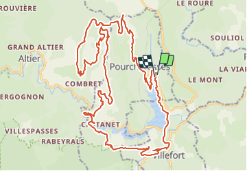
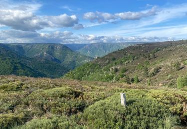
Ruta Bici de montaña de 33 km a descubrir en Occitania, Lozère, Pourcharesses. Esta ruta ha sido propuesta por solisolo.
Descripción
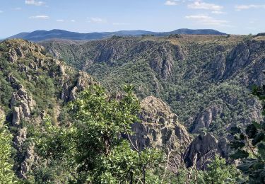
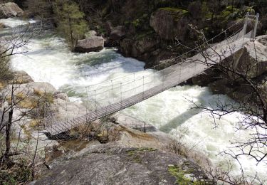
Quelques passages techniques, mais vites oubliés par les magnifiques paysages, il faut quand même être en bonne condition physique.
Localización
País:
France
Región :
Occitania
Departamento/provincia :
Lozère
Municipio :
Pourcharesses
Localidad:
Unknown
Salida:(Dec)
Salida:(UTM)
573718 ; 4924371 (31T) N.
Comentarios
Excursiones cerca
![Excursión Senderismo Pied-de-Borne - GRP Tour du Chassezac en 2 jours - Photo](https://media.geolcdn.com/t/375/260/4939cb41-dd3b-4cb9-aebc-74687e919567.jpg&format=jpg&maxdim=2)
![Senderismo Senderismo](https://static1.geolcdn.com/sitytour/trail-icons/101.png)
GRP Tour du Chassezac en 2 jours
Senderismo
Difícil
Pied-de-Borne,
Occitania,
Lozère,
France
![](/images/other/stat-length.png)
25 km | 36 km-effort
6h 50min
![](https://static1.geolcdn.com/siteimages/upload/files/16400158638029165_repeat_loop_refresh_sync_direction_icon.png)
No
![Excursión A pie Malons-et-Elze - GR 44 - Photo](https://media.geolcdn.com/t/375/260/f0c265fe-7de1-43be-8da0-90c630caf3a2.jpeg&format=jpg&maxdim=2)
![A pie A pie](https://static1.geolcdn.com/sitytour/trail-icons/100.png)
![Excursión Senderismo Pourcharesses - au coeur des gorges du chassezac au départ de Villefort - Photo](https://media.geolcdn.com/t/375/260/648a2635-721c-411c-9b65-d15697fb8c14.jpg&format=jpg&maxdim=2)
![Senderismo Senderismo](https://static1.geolcdn.com/sitytour/trail-icons/101.png)
au coeur des gorges du chassezac au départ de Villefort
Senderismo
Difícil
Pourcharesses,
Occitania,
Lozère,
France
![](/images/other/stat-length.png)
17,6 km | 28 km-effort
7h 12min
![](https://static1.geolcdn.com/siteimages/upload/files/16400158638029165_repeat_loop_refresh_sync_direction_icon.png)
Sí
![Excursión Senderismo Prévenchères - Gorges de Chassezac - Photo](https://media.geolcdn.com/t/375/260/49ddc4e4-e66c-491b-9c51-4f66b0d6413a.jpg&format=jpg&maxdim=2)
![Senderismo Senderismo](https://static1.geolcdn.com/sitytour/trail-icons/101.png)
Gorges de Chassezac
Senderismo
Difícil
Prévenchères,
Occitania,
Lozère,
France
![](/images/other/stat-length.png)
19 km | 30 km-effort
7h 33min
![](https://static1.geolcdn.com/siteimages/upload/files/16400158638029165_repeat_loop_refresh_sync_direction_icon.png)
Sí
![Excursión Senderismo Pied-de-Borne - Le tour du Chassezac - Photo](https://media.geolcdn.com/t/375/260/befb1c71-a310-40db-8e8f-df4d5ec91bd5.jpg&format=jpg&maxdim=2)
![Senderismo Senderismo](https://static1.geolcdn.com/sitytour/trail-icons/101.png)
Le tour du Chassezac
Senderismo
Muy difícil
Pied-de-Borne,
Occitania,
Lozère,
France
![](/images/other/stat-length.png)
49 km | 72 km-effort
37h 28min
![](https://static1.geolcdn.com/siteimages/upload/files/16400158638029165_repeat_loop_refresh_sync_direction_icon.png)
Sí
![Excursión Senderismo Pied-de-Borne - Le tour du chassezac - Photo](https://media.geolcdn.com/t/375/260/34d1863b-5946-4591-908e-d59df5d48945.jpg&format=jpg&maxdim=2)
![Senderismo Senderismo](https://static1.geolcdn.com/sitytour/trail-icons/101.png)
Le tour du chassezac
Senderismo
Muy difícil
Pied-de-Borne,
Occitania,
Lozère,
France
![](/images/other/stat-length.png)
49 km | 72 km-effort
16h 34min
![](https://static1.geolcdn.com/siteimages/upload/files/16400158638029165_repeat_loop_refresh_sync_direction_icon.png)
Sí
![Excursión Senderismo Prévenchères - La garde guerin - Photo](https://media.geolcdn.com/t/375/260/f4d5d102-7541-4721-bc49-35572d8c8339.jpg&format=jpg&maxdim=2)
![Senderismo Senderismo](https://static1.geolcdn.com/sitytour/trail-icons/101.png)
La garde guerin
Senderismo
Muy fácil
Prévenchères,
Occitania,
Lozère,
France
![](/images/other/stat-length.png)
6,1 km | 7,4 km-effort
1h 39min
![](https://static1.geolcdn.com/siteimages/upload/files/16400158638029165_repeat_loop_refresh_sync_direction_icon.png)
Sí
![Excursión Senderismo Prévenchères - Gorges du Chassezac au départ de la Garde guérin - Photo](https://media.geolcdn.com/t/375/260/1d0812e0-004d-45c5-80f3-cf534f71bab6.jpg&format=jpg&maxdim=2)
![Senderismo Senderismo](https://static1.geolcdn.com/sitytour/trail-icons/101.png)
Gorges du Chassezac au départ de la Garde guérin
Senderismo
Difícil
Prévenchères,
Occitania,
Lozère,
France
![](/images/other/stat-length.png)
10 km | 17,2 km-effort
4h 3min
![](https://static1.geolcdn.com/siteimages/upload/files/16400158638029165_repeat_loop_refresh_sync_direction_icon.png)
Sí
![Excursión Senderismo Prévenchères - La Garde Guerin - Photo](https://media.geolcdn.com/t/375/260/d0963631-787c-4221-b6f7-68f04bbfe444.jpg&format=jpg&maxdim=2)
![Senderismo Senderismo](https://static1.geolcdn.com/sitytour/trail-icons/101.png)
La Garde Guerin
Senderismo
Muy difícil
Prévenchères,
Occitania,
Lozère,
France
![](/images/other/stat-length.png)
12,4 km | 21 km-effort
5h 5min
![](https://static1.geolcdn.com/siteimages/upload/files/16400158638029165_repeat_loop_refresh_sync_direction_icon.png)
Sí