![](/images/other/stat-length.png)
![Excursión Senderismo Theux - La Charmille - Les Cours - Photo](https://media.geolcdn.com/t/1900/400/589d8d38-05ed-42d0-9c48-7a8ffbef0466.jpg&format=pjpeg&maxdim=2)
La Charmille - Les Cours
alfreson
Usuario
![Longitud](/images/other/stat-length.png)
Longitud
9,6 km
![Boucle](https://static1.geolcdn.com/siteimages/upload/files/16400158638029165_repeat_loop_refresh_sync_direction_icon.png)
Boucle
No
Fecha de creación :
2019-08-29 12:56:32.0
Última modificación :
2019-08-29 15:28:42.146
![Senderismo](https://static1.geolcdn.com/sitytour/trail-icons/101.png)
2h25
Dificultad : Desconocido
![Paseo ecuestre](https://static1.geolcdn.com/sitytour/trail-icons/301.png)
--
Dificultad : Desconocido
![Escanee este código QR para abrir la excursión en la aplicación SityTrail](https://capi.geolives.com/qq0zvz2zws4bq2lad0pu/sitytour/trails/2185878/qr.png?size=200)
Aplicación GPS de excursión GRATIS
A propósito
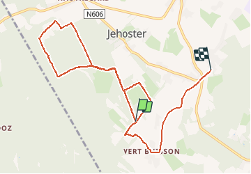
Ruta Senderismo de 9,6 km a descubrir en Valonia, Lieja, Theux. Esta ruta ha sido propuesta por alfreson.
Descripción
On commence par la magnifique Charmille, puis on boucle dans les bois et petits chemins de campagne pour rejoindre l’écurie de mon amie Chri
Localización
País:
Belgium
Región :
Valonia
Departamento/provincia :
Lieja
Municipio :
Theux
Localidad:
La Reid
Salida:(Dec)
Salida:(UTM)
697203 ; 5594426 (31U) N.
Comentarios
Excursiones cerca
![Excursión Senderismo Theux - RB-Lg-24_La-Reid_via-racc-1 - Photo](https://media.geolcdn.com/t/375/260/ext.jpg?maxdim=2&url=https%3A%2F%2Fservices.sitytrail.com%2FGeolivesWS%2FDownloadMedia.ashx%3FTrailID%3D400924%26Media%3De46f0d15-4872-47d2-9c6f-9e812d51cefb.jpg)
![Senderismo Senderismo](https://static1.geolcdn.com/sitytour/trail-icons/101.png)
RB-Lg-24_La-Reid_via-racc-1
Senderismo
(11)
Theux,
Valonia,
Lieja,
Belgium
![](/images/other/stat-length.png)
15,9 km | 21 km-effort
4h 50min
![](https://static1.geolcdn.com/siteimages/upload/files/16400158638029165_repeat_loop_refresh_sync_direction_icon.png)
Sí
![Excursión Senderismo Theux - RB-Lg-24_La-Reid - Photo](https://media.geolcdn.com/t/375/260/ext.jpg?maxdim=2&url=https%3A%2F%2Fservices.sitytrail.com%2FGeolivesWS%2FDownloadMedia.ashx%3FTrailID%3D400922%26Media%3De46f0d15-4872-47d2-9c6f-9e812d51cefb.jpg)
![Senderismo Senderismo](https://static1.geolcdn.com/sitytour/trail-icons/101.png)
![Excursión Senderismo Aywaille - RB-Lg-12 - De Sougné-Remouchamps à Deigné et retour - Photo](https://media.geolcdn.com/t/375/260/ext.jpg?maxdim=2&url=https%3A%2F%2Fservices.sitytrail.com%2FGeolivesWS%2FDownloadMedia.ashx%3FTrailID%3D179570%26Media%3D1074d230-2da3-49cf-8210-a5f6b46fd870.jpg)
![Senderismo Senderismo](https://static1.geolcdn.com/sitytour/trail-icons/101.png)
RB-Lg-12 - De Sougné-Remouchamps à Deigné et retour
Senderismo
Difícil
(9)
Aywaille,
Valonia,
Lieja,
Belgium
![](/images/other/stat-length.png)
24 km | 34 km-effort
7h 39min
![](https://static1.geolcdn.com/siteimages/upload/files/16400158638029165_repeat_loop_refresh_sync_direction_icon.png)
Sí
![Excursión Senderismo Aywaille - Petite remontée du Ninglispo - Photo](https://media.geolcdn.com/t/375/260/ext.jpg?maxdim=2&url=https%3A%2F%2Fservices.sitytrail.com%2FGeolivesWS%2FDownloadMedia.ashx%3FTrailID%3D536482%26Media%3D20160311161707.jpg)
![Senderismo Senderismo](https://static1.geolcdn.com/sitytour/trail-icons/101.png)
Petite remontée du Ninglispo
Senderismo
Medio
(9)
Aywaille,
Valonia,
Lieja,
Belgium
![](/images/other/stat-length.png)
6,7 km | 9,7 km-effort
2h 11min
![](https://static1.geolcdn.com/siteimages/upload/files/16400158638029165_repeat_loop_refresh_sync_direction_icon.png)
Sí
![Excursión Senderismo Aywaille - RB-LG-12 - Raccourci 2 - Photo](https://media.geolcdn.com/t/375/260/ext.jpg?maxdim=2&url=https%3A%2F%2Fservices.sitytrail.com%2FGeolivesWS%2FDownloadMedia.ashx%3FTrailID%3D209433%26Media%3D1f1ef83d-c0c7-4521-b15a-02c5e9e7c1f1.jpg)
![Senderismo Senderismo](https://static1.geolcdn.com/sitytour/trail-icons/101.png)
RB-LG-12 - Raccourci 2
Senderismo
Difícil
(6)
Aywaille,
Valonia,
Lieja,
Belgium
![](/images/other/stat-length.png)
17 km | 25 km-effort
5h 46min
![](https://static1.geolcdn.com/siteimages/upload/files/16400158638029165_repeat_loop_refresh_sync_direction_icon.png)
Sí
![Senderismo Senderismo](https://static1.geolcdn.com/sitytour/trail-icons/101.png)
20220717 - HUWAO La Reid - 7 Km
Senderismo
Medio
(2)
Theux,
Valonia,
Lieja,
Belgium
![](/images/other/stat-length.png)
7 km | 9,5 km-effort
2h 34min
![](https://static1.geolcdn.com/siteimages/upload/files/16400158638029165_repeat_loop_refresh_sync_direction_icon.png)
Sí
![Excursión Senderismo Theux - vertbuisson . chefna . porallee . éolienne bronrome . vertbuisson - Photo](https://media.geolcdn.com/t/375/260/909f6ba2-ca5e-4f73-8360-60c62378ed9c.jpg&format=jpg&maxdim=2)
![Senderismo Senderismo](https://static1.geolcdn.com/sitytour/trail-icons/101.png)
vertbuisson . chefna . porallee . éolienne bronrome . vertbuisson
Senderismo
Muy fácil
(1)
Theux,
Valonia,
Lieja,
Belgium
![](/images/other/stat-length.png)
8,8 km | 10,4 km-effort
2h 10min
![](https://static1.geolcdn.com/siteimages/upload/files/16400158638029165_repeat_loop_refresh_sync_direction_icon.png)
No
![Excursión Senderismo Aywaille - RB-Lg-12 - Raccourci 1 - Photo](https://media.geolcdn.com/t/375/260/ext.jpg?maxdim=2&url=https%3A%2F%2Fservices.sitytrail.com%2FGeolivesWS%2FDownloadMedia.ashx%3FTrailID%3D209432%26Media%3D1074d230-2da3-49cf-8210-a5f6b46fd870.jpg)
![Senderismo Senderismo](https://static1.geolcdn.com/sitytour/trail-icons/101.png)
RB-Lg-12 - Raccourci 1
Senderismo
Difícil
(1)
Aywaille,
Valonia,
Lieja,
Belgium
![](/images/other/stat-length.png)
21 km | 31 km-effort
6h 42min
![](https://static1.geolcdn.com/siteimages/upload/files/16400158638029165_repeat_loop_refresh_sync_direction_icon.png)
Sí
![Excursión Senderismo Theux - CHEMIN_DES_SOURCES_Etape_9 - Photo](https://media.geolcdn.com/t/375/260/787ff85b-7dc6-41bf-a4d4-e52e973994d3.jpg&format=jpg&maxdim=2)
![Senderismo Senderismo](https://static1.geolcdn.com/sitytour/trail-icons/101.png)
CHEMIN_DES_SOURCES_Etape_9
Senderismo
Muy difícil
(1)
Theux,
Valonia,
Lieja,
Belgium
![](/images/other/stat-length.png)
15,7 km | 21 km-effort
4h 46min
![](https://static1.geolcdn.com/siteimages/upload/files/16400158638029165_repeat_loop_refresh_sync_direction_icon.png)
No