![](/images/other/stat-length.png)
![Excursión Senderismo Mont-Albert - Wikiloc - Mont Olivine - Photo](https://media.geolcdn.com/t/1900/400/ext.pjpeg?maxdim=2&url=https%3A%2F%2Fstatic1.geolcdn.com%2Fsiteimages%2Fupload%2Ffiles%2F1553511878bg_sport_marche.png)
Wikiloc - Mont Olivine
Alizée.pee
Usuario GUIDE
![Longitud](/images/other/stat-length.png)
Longitud
8 km
![Altitud máxima](https://static1.geolcdn.com/siteimages/upload/files/1508320355ic_sort_altitude_max_24dp.png)
Altitud máxima
668 m
![Desnivel positivo](https://static1.geolcdn.com/siteimages/upload/files/1508320355ic_sort_den_pos_24dp.png)
Desnivel positivo
283 m
![Km-Effort](/images/other/stat-length.png)
Km-Effort
12,1 km
![Altitud mínima](https://static1.geolcdn.com/siteimages/upload/files/1508320355ic_sort_altitude_min_24dp.png)
Altitud mínima
304 m
![Desnivel negativo](https://static1.geolcdn.com/siteimages/upload/files/1508320355ic_sort_den_neg_24dp.png)
Desnivel negativo
389 m
![Boucle](https://static1.geolcdn.com/siteimages/upload/files/16400158638029165_repeat_loop_refresh_sync_direction_icon.png)
Boucle
No
Fecha de creación :
2019-08-22 12:30:29.249
Última modificación :
2019-08-22 12:32:10.589
![Senderismo](https://static1.geolcdn.com/sitytour/trail-icons/101.png)
2h27
Dificultad : Medio
![Escanee este código QR para abrir la excursión en la aplicación SityTrail](https://capi.geolives.com/qq0zvz2zws4bq2lad0pu/sitytour/trails/2179171/qr.png?size=200)
Aplicación GPS de excursión GRATIS
A propósito
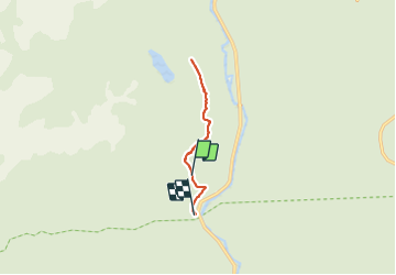
Ruta Senderismo de 8 km a descubrir en Quebec, La Haute-Gaspésie, Mont-Albert. Esta ruta ha sido propuesta por Alizée.pee.
Descripción
Le sommet dénudé du Mont Olivine permet une vue imprenable sur les monts Albert et Richardson. Très belle randonnée !
Localización
País:
Canada
Región :
Quebec
Departamento/provincia :
La Haute-Gaspésie
Municipio :
Mont-Albert
Localidad:
Unknown
Salida:(Dec)
Salida:(UTM)
711503 ; 5419138 (19U) N.
Comentarios
Excursiones cerca
![Excursión Senderismo Mont-Albert - 2014-08-10 18:36:31 - Photo](https://media.geolcdn.com/t/375/260/ext.jpg?maxdim=2&url=https%3A%2F%2Fstatic1.geolcdn.com%2Fsiteimages%2Fupload%2Ffiles%2F1553511878bg_sport_marche.png)
![Senderismo Senderismo](https://static1.geolcdn.com/sitytour/trail-icons/101.png)
2014-08-10 18:36:31
Senderismo
Fácil
(1)
Mont-Albert,
Quebec,
La Haute-Gaspésie,
Canada
![](/images/other/stat-length.png)
4,5 km | 7 km-effort
1h 50min
![](https://static1.geolcdn.com/siteimages/upload/files/16400158638029165_repeat_loop_refresh_sync_direction_icon.png)
Sí
![Excursión Senderismo Mont-Albert - Wikiloc - Parc National de la Gaspésie - Mont Ernest Laforce - Photo](https://media.geolcdn.com/t/375/260/ext.jpg?maxdim=2&url=https%3A%2F%2Fstatic1.geolcdn.com%2Fsiteimages%2Fupload%2Ffiles%2F1553511878bg_sport_marche.png)
![Senderismo Senderismo](https://static1.geolcdn.com/sitytour/trail-icons/101.png)
Wikiloc - Parc National de la Gaspésie - Mont Ernest Laforce
Senderismo
Medio
Mont-Albert,
Quebec,
La Haute-Gaspésie,
Canada
![](/images/other/stat-length.png)
5,5 km | 8,6 km-effort
1h 46min
![](https://static1.geolcdn.com/siteimages/upload/files/16400158638029165_repeat_loop_refresh_sync_direction_icon.png)
Sí
![Excursión Senderismo Mont-Albert - Tour du mont Ernest Laforce - Photo](https://media.geolcdn.com/t/375/260/ext.jpg?maxdim=2&url=https%3A%2F%2Fstatic1.geolcdn.com%2Fsiteimages%2Fupload%2Ffiles%2F1553511878bg_sport_marche.png)
![Senderismo Senderismo](https://static1.geolcdn.com/sitytour/trail-icons/101.png)
Tour du mont Ernest Laforce
Senderismo
Muy fácil
Mont-Albert,
Quebec,
La Haute-Gaspésie,
Canada
![](/images/other/stat-length.png)
7,8 km | 11,1 km-effort
1h 15min
![](https://static1.geolcdn.com/siteimages/upload/files/16400158638029165_repeat_loop_refresh_sync_direction_icon.png)
No
![Excursión Senderismo Mont-Albert - mont Ernest Laforce - Photo](https://media.geolcdn.com/t/375/260/ext.jpg?maxdim=2&url=https%3A%2F%2Fstatic1.geolcdn.com%2Fsiteimages%2Fupload%2Ffiles%2F1553511878bg_sport_marche.png)
![Senderismo Senderismo](https://static1.geolcdn.com/sitytour/trail-icons/101.png)
mont Ernest Laforce
Senderismo
Fácil
Mont-Albert,
Quebec,
La Haute-Gaspésie,
Canada
![](/images/other/stat-length.png)
4,8 km | 7,3 km-effort
1h 30min
![](https://static1.geolcdn.com/siteimages/upload/files/16400158638029165_repeat_loop_refresh_sync_direction_icon.png)
Sí
![Excursión Senderismo Mont-Albert - mont ernest laforce - Photo](https://media.geolcdn.com/t/375/260/ext.jpg?maxdim=2&url=https%3A%2F%2Fstatic1.geolcdn.com%2Fsiteimages%2Fupload%2Ffiles%2F1553511878bg_sport_marche.png)
![Senderismo Senderismo](https://static1.geolcdn.com/sitytour/trail-icons/101.png)
mont ernest laforce
Senderismo
Fácil
Mont-Albert,
Quebec,
La Haute-Gaspésie,
Canada
![](/images/other/stat-length.png)
4,7 km | 7,1 km-effort
1h 46min
![](https://static1.geolcdn.com/siteimages/upload/files/16400158638029165_repeat_loop_refresh_sync_direction_icon.png)
Sí
![Excursión Senderismo Mont-Albert - Mt Ernest Laforce Parc de Gaspésie - Photo](https://media.geolcdn.com/t/375/260/ext.jpg?maxdim=2&url=https%3A%2F%2Fstatic1.geolcdn.com%2Fsiteimages%2Fupload%2Ffiles%2F1553511878bg_sport_marche.png)
![Senderismo Senderismo](https://static1.geolcdn.com/sitytour/trail-icons/101.png)
Mt Ernest Laforce Parc de Gaspésie
Senderismo
Fácil
Mont-Albert,
Quebec,
La Haute-Gaspésie,
Canada
![](/images/other/stat-length.png)
5 km | 7,5 km-effort
1h 33min
![](https://static1.geolcdn.com/siteimages/upload/files/16400158638029165_repeat_loop_refresh_sync_direction_icon.png)
Sí
![Excursión Senderismo Mont-Albert - CANADA PARK GASPESIE Mont Ernest_2018_10_02 - Photo](https://media.geolcdn.com/t/375/260/ext.jpg?maxdim=2&url=https%3A%2F%2Fstatic1.geolcdn.com%2Fsiteimages%2Fupload%2Ffiles%2F1553511878bg_sport_marche.png)
![Senderismo Senderismo](https://static1.geolcdn.com/sitytour/trail-icons/101.png)
CANADA PARK GASPESIE Mont Ernest_2018_10_02
Senderismo
Muy fácil
Mont-Albert,
Quebec,
La Haute-Gaspésie,
Canada
![](/images/other/stat-length.png)
4,3 km | 6,8 km-effort
Desconocido
![](https://static1.geolcdn.com/siteimages/upload/files/16400158638029165_repeat_loop_refresh_sync_direction_icon.png)
Sí
![Excursión Senderismo Mont-Albert - boucle Laporte - Photo](https://media.geolcdn.com/t/375/260/ext.jpg?maxdim=2&url=https%3A%2F%2Fstatic1.geolcdn.com%2Fsiteimages%2Fupload%2Ffiles%2F1553511878bg_sport_marche.png)
![Senderismo Senderismo](https://static1.geolcdn.com/sitytour/trail-icons/101.png)
boucle Laporte
Senderismo
Muy fácil
Mont-Albert,
Quebec,
La Haute-Gaspésie,
Canada
![](/images/other/stat-length.png)
5,6 km | 8,2 km-effort
1h 47min
![](https://static1.geolcdn.com/siteimages/upload/files/16400158638029165_repeat_loop_refresh_sync_direction_icon.png)
Sí