![](/images/other/stat-length.png)
![Excursión Senderismo Les Avanchers-Valmorel - Valmorel / Doucy Station / Doucy village / Raclaz / Valmorel - Photo](https://media.geolcdn.com/t/1900/400/6c426625-477d-4c72-b56f-426b9e89155a.jpg&format=pjpeg&maxdim=2)
Valmorel / Doucy Station / Doucy village / Raclaz / Valmorel
zazie
Usuario
![Longitud](/images/other/stat-length.png)
![Altitud máxima](https://static1.geolcdn.com/siteimages/upload/files/1508320355ic_sort_altitude_max_24dp.png)
![Desnivel positivo](https://static1.geolcdn.com/siteimages/upload/files/1508320355ic_sort_den_pos_24dp.png)
![Km-Effort](/images/other/stat-length.png)
![Altitud mínima](https://static1.geolcdn.com/siteimages/upload/files/1508320355ic_sort_altitude_min_24dp.png)
![Desnivel negativo](https://static1.geolcdn.com/siteimages/upload/files/1508320355ic_sort_den_neg_24dp.png)
![Boucle](https://static1.geolcdn.com/siteimages/upload/files/16400158638029165_repeat_loop_refresh_sync_direction_icon.png)
![Senderismo](https://static1.geolcdn.com/sitytour/trail-icons/101.png)
3h38
Dificultad : Fácil
![Escanee este código QR para abrir la excursión en la aplicación SityTrail](https://capi.geolives.com/qq0zvz2zws4bq2lad0pu/sitytour/trails/2155404/qr.png?size=200)
Aplicación GPS de excursión GRATIS
A propósito
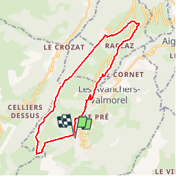
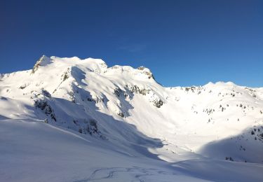
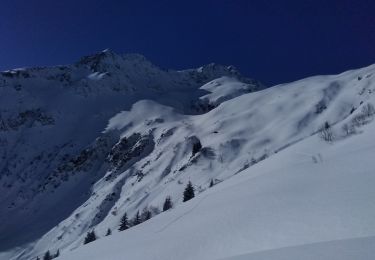
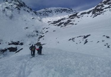
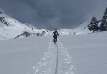
Ruta Senderismo de 16,4 km a descubrir en Auvergne-Rhône-Alpes, Saboya, Les Avanchers-Valmorel. Esta ruta ha sido propuesta por zazie.
Descripción
Boucle au départ de Valmorel par le télésiège des Planchettes, liaison à pieds jusqu'au télésiège de Combelouvière pour rejoindre directement Doucy Station. Retour par les villages de Raclaz (et son musée d'antan), le Regnier, le Villaret, le Meiller (coupé au plus court pour éviter la route), Lancheverne et Fontaine. Profitez des fontaines placées dans chaque village pour mieux absorber le dénivelé.
Localización
Comentarios
Excursiones cerca
![Excursión Senderismo Les Belleville - Tour de Creve Tete - Photo](https://media.geolcdn.com/t/375/260/775f7fbd-61fe-4dac-aa88-5ad251aeb72f.jpg&format=jpg&maxdim=2)
![Senderismo Senderismo](https://static1.geolcdn.com/sitytour/trail-icons/101.png)
Senderismo
![](/images/other/stat-length.png)
![](https://static1.geolcdn.com/siteimages/upload/files/16400158638029165_repeat_loop_refresh_sync_direction_icon.png)
![Excursión Esquí de fondo La Léchère - grand pic - Photo](https://media.geolcdn.com/t/375/260/9cfac439-c6a9-45dc-854a-66e0fdb870fb.jpg&format=jpg&maxdim=2)
![Esquí de fondo Esquí de fondo](https://static1.geolcdn.com/sitytour/trail-icons/503.png)
Esquí de fondo
![](/images/other/stat-length.png)
![](https://static1.geolcdn.com/siteimages/upload/files/16400158638029165_repeat_loop_refresh_sync_direction_icon.png)
![Excursión Esquí de fondo La Léchère - Aiguille de la Balme - Photo](https://media.geolcdn.com/t/375/260/a3d2e41a-1caa-427e-9d80-b714bd5aac52.jpg&format=jpg&maxdim=2)
![Esquí de fondo Esquí de fondo](https://static1.geolcdn.com/sitytour/trail-icons/503.png)
Esquí de fondo
![](/images/other/stat-length.png)
![](https://static1.geolcdn.com/siteimages/upload/files/16400158638029165_repeat_loop_refresh_sync_direction_icon.png)
![Excursión Esquí de fondo La Léchère - tricotage vers Les Teurs. - Photo](https://media.geolcdn.com/t/375/260/00642df7-11bb-44cc-a75b-471b0d819f21.jpg&format=jpg&maxdim=2)
![Esquí de fondo Esquí de fondo](https://static1.geolcdn.com/sitytour/trail-icons/503.png)
Esquí de fondo
![](/images/other/stat-length.png)
![](https://static1.geolcdn.com/siteimages/upload/files/16400158638029165_repeat_loop_refresh_sync_direction_icon.png)
![Excursión Esquí de fondo La Léchère - Les marmottes noires - Photo](https://media.geolcdn.com/t/375/260/b231a722-c719-4ca9-8520-60ac6ec172da.jpg&format=jpg&maxdim=2)
![Esquí de fondo Esquí de fondo](https://static1.geolcdn.com/sitytour/trail-icons/503.png)
Esquí de fondo
![](/images/other/stat-length.png)
![](https://static1.geolcdn.com/siteimages/upload/files/16400158638029165_repeat_loop_refresh_sync_direction_icon.png)
![Excursión Esquí de fondo La Léchère - le. chalet de Colomban - Photo](https://media.geolcdn.com/t/375/260/8594f6fb-22c5-4295-85ac-3463a33ec2ed.jpg&format=jpg&maxdim=2)
![Esquí de fondo Esquí de fondo](https://static1.geolcdn.com/sitytour/trail-icons/503.png)
Esquí de fondo
![](/images/other/stat-length.png)
![](https://static1.geolcdn.com/siteimages/upload/files/16400158638029165_repeat_loop_refresh_sync_direction_icon.png)
![Excursión Esquí de fondo La Léchère - la pointe de la combe bronsin - Photo](https://media.geolcdn.com/t/375/260/15964385-eb75-4e54-ab69-efa3a84c15ec.jpg&format=jpg&maxdim=2)
![Esquí de fondo Esquí de fondo](https://static1.geolcdn.com/sitytour/trail-icons/503.png)
Esquí de fondo
![](/images/other/stat-length.png)
![](https://static1.geolcdn.com/siteimages/upload/files/16400158638029165_repeat_loop_refresh_sync_direction_icon.png)
![Excursión Esquí de fondo La Léchère - Roche noire - Photo](https://media.geolcdn.com/t/375/260/9b9401f9-2d0c-481a-8b4d-bcf0642761c5.jpg&format=jpg&maxdim=2)
![Esquí de fondo Esquí de fondo](https://static1.geolcdn.com/sitytour/trail-icons/503.png)
Esquí de fondo
![](/images/other/stat-length.png)
![](https://static1.geolcdn.com/siteimages/upload/files/16400158638029165_repeat_loop_refresh_sync_direction_icon.png)
![Excursión Esquí de fondo La Léchère - les portes de Montmélian - Photo](https://media.geolcdn.com/t/375/260/88246016-bae4-428f-a0ba-d11da7754eea.jpg&format=jpg&maxdim=2)
![Esquí de fondo Esquí de fondo](https://static1.geolcdn.com/sitytour/trail-icons/503.png)
Esquí de fondo
![](/images/other/stat-length.png)
![](https://static1.geolcdn.com/siteimages/upload/files/16400158638029165_repeat_loop_refresh_sync_direction_icon.png)