![](/images/other/stat-length.png)
![Excursión Senderismo Aspremont - Tracé_30-JUIL-19 144757 - Photo](https://media.geolcdn.com/t/1900/400/ext.pjpeg?maxdim=2&url=https%3A%2F%2Fstatic1.geolcdn.com%2Fsiteimages%2Fupload%2Ffiles%2F1553511878bg_sport_marche.png)
Tracé_30-JUIL-19 144757
rigol05
Usuario
![Longitud](/images/other/stat-length.png)
![Altitud máxima](https://static1.geolcdn.com/siteimages/upload/files/1508320355ic_sort_altitude_max_24dp.png)
![Desnivel positivo](https://static1.geolcdn.com/siteimages/upload/files/1508320355ic_sort_den_pos_24dp.png)
![Km-Effort](/images/other/stat-length.png)
![Altitud mínima](https://static1.geolcdn.com/siteimages/upload/files/1508320355ic_sort_altitude_min_24dp.png)
![Desnivel negativo](https://static1.geolcdn.com/siteimages/upload/files/1508320355ic_sort_den_neg_24dp.png)
![Boucle](https://static1.geolcdn.com/siteimages/upload/files/16400158638029165_repeat_loop_refresh_sync_direction_icon.png)
![Senderismo](https://static1.geolcdn.com/sitytour/trail-icons/101.png)
--
Dificultad : Medio
![Escanee este código QR para abrir la excursión en la aplicación SityTrail](https://capi.geolives.com/qq0zvz2zws4bq2lad0pu/sitytour/trails/2154493/qr.png?size=200)
Aplicación GPS de excursión GRATIS
A propósito
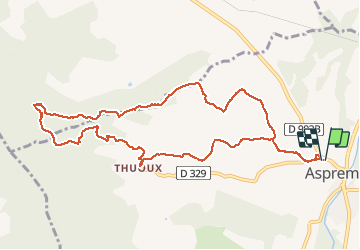
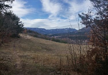
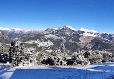
Ruta Senderismo de 11,4 km a descubrir en Provenza-Alpes-Costa Azul, Altos Alpes, Aspremont. Esta ruta ha sido propuesta por rigol05.
Descripción
Sortie du 30 juillet 2019 - Départ Aspremont, chemin du château
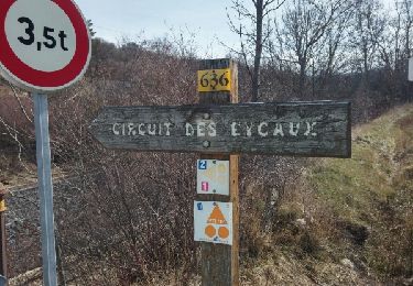
Suivre l'itinéraire " Tour de Thuoux" balisé jaune. Au carrefour des pistes, laisser le chemin de gauche et contourner le Serre des Istans par la droite et rejoindre le Collet. Monter sur la droite NO et chercher une trace de sentier aléatoire jusqu'à Serre Long. Rester sur la ligne de crête, à la côte 909m un sentier mieux marqué conduit à la cabane des Fanges. Des Fanges suivre le balisage VTT présent mais pas toujours évident. La descente sur Thuoux s'effectue sur une piste traversant une zone de marne. Thuoux, attention, ne pas suivre la route goudronnée mais à la route, prendre de suite à gauche, le sentier balisé jaune menant au prieuré et au cimetière. Retour par l'itinéraire classique "Tour de Thuoux.
Localización
Comentarios
Excursiones cerca
![Excursión Senderismo Aspres-sur-Buëch - Aspres-Le Villard - Photo](https://media.geolcdn.com/t/375/260/754457fe-0962-4c87-8c63-49e84b5580be.jpg&format=jpg&maxdim=2)
![Senderismo Senderismo](https://static1.geolcdn.com/sitytour/trail-icons/101.png)
Senderismo
![](/images/other/stat-length.png)
![](https://static1.geolcdn.com/siteimages/upload/files/16400158638029165_repeat_loop_refresh_sync_direction_icon.png)
![Excursión Senderismo Aspres-sur-Buëch - Aspres sur Buech Antennes - Photo](https://media.geolcdn.com/t/375/260/b974de03-969d-499a-a271-3b3d3e5e29ef.jpg&format=jpg&maxdim=2)
![Senderismo Senderismo](https://static1.geolcdn.com/sitytour/trail-icons/101.png)
Senderismo
![](/images/other/stat-length.png)
![](https://static1.geolcdn.com/siteimages/upload/files/16400158638029165_repeat_loop_refresh_sync_direction_icon.png)
![Excursión Carrera Aspres-sur-Buëch - Trail 06 - La Longeagne - Photo](https://media.geolcdn.com/t/375/260/bd547bc4-f378-45f6-8716-12e8ff087506.jpg&format=jpg&maxdim=2)
![Carrera Carrera](https://static1.geolcdn.com/sitytour/trail-icons/103.png)
Carrera
![](/images/other/stat-length.png)
![](https://static1.geolcdn.com/siteimages/upload/files/16400158638029165_repeat_loop_refresh_sync_direction_icon.png)
![Excursión Senderismo Sigottier - Boucle des Michons Départ Sigottier 322+ - Photo](https://media.geolcdn.com/t/375/260/e958f610-dae3-4d24-8ab2-439a59518395.jpg&format=jpg&maxdim=2)
![Senderismo Senderismo](https://static1.geolcdn.com/sitytour/trail-icons/101.png)
Senderismo
![](/images/other/stat-length.png)
![](https://static1.geolcdn.com/siteimages/upload/files/16400158638029165_repeat_loop_refresh_sync_direction_icon.png)
![Excursión Senderismo Chabestan - Champignons Chabestan - Photo](https://media.geolcdn.com/t/375/260/934f9c1f-bb56-41d4-b225-a4e23d10df28.jpg&format=jpg&maxdim=2)
![Senderismo Senderismo](https://static1.geolcdn.com/sitytour/trail-icons/101.png)
Senderismo
![](/images/other/stat-length.png)
![](https://static1.geolcdn.com/siteimages/upload/files/16400158638029165_repeat_loop_refresh_sync_direction_icon.png)
![Excursión Senderismo Aspres-sur-Buëch - Circuit des Eygau.(09-03-17) - Photo](https://media.geolcdn.com/t/375/260/ext.jpg?maxdim=2&url=https%3A%2F%2Fservices.sitytrail.com%2FGeolivesWS%2FDownloadMedia.ashx%3FTrailID%3D710834%26Media%3Dfix__20170309115917.jpg)
![Senderismo Senderismo](https://static1.geolcdn.com/sitytour/trail-icons/101.png)
Senderismo
![](/images/other/stat-length.png)
![](https://static1.geolcdn.com/siteimages/upload/files/16400158638029165_repeat_loop_refresh_sync_direction_icon.png)
![Excursión Senderismo Aspres-sur-Buëch - Circuit de la Digue. - Photo](https://media.geolcdn.com/t/375/260/ext.jpg?maxdim=2&url=https%3A%2F%2Fservices.sitytrail.com%2FGeolivesWS%2FDownloadMedia.ashx%3FTrailID%3D694564%26Media%3Dfix__20170207131547.jpg)
![Senderismo Senderismo](https://static1.geolcdn.com/sitytour/trail-icons/101.png)
Senderismo
![](/images/other/stat-length.png)
![](https://static1.geolcdn.com/siteimages/upload/files/16400158638029165_repeat_loop_refresh_sync_direction_icon.png)
![Excursión Bici de montaña Saint-Pierre-d'Argençon - HA J3 long - Photo](https://media.geolcdn.com/t/375/260/ext.jpg?maxdim=2&url=https%3A%2F%2Fstatic1.geolcdn.com%2Fsiteimages%2Fupload%2Ffiles%2F1524743154velo.jpg)
![Bici de montaña Bici de montaña](https://static1.geolcdn.com/sitytour/trail-icons/202.png)
Bici de montaña
![](/images/other/stat-length.png)
![](https://static1.geolcdn.com/siteimages/upload/files/16400158638029165_repeat_loop_refresh_sync_direction_icon.png)
![Excursión Senderismo Aspres-sur-Buëch - Montagne Saint-Apôtre - Photo](https://media.geolcdn.com/t/375/260/566d48ab-c357-432d-9f85-1b88de97ed8a.jpg&format=jpg&maxdim=2)
![Senderismo Senderismo](https://static1.geolcdn.com/sitytour/trail-icons/101.png)
Senderismo
![](/images/other/stat-length.png)
![](https://static1.geolcdn.com/siteimages/upload/files/16400158638029165_repeat_loop_refresh_sync_direction_icon.png)