![](/images/other/stat-length.png)
![Excursión Senderismo Thérondels - Balade à la presqu''ile de Laussac - Thérondels - Photo](https://media.geolcdn.com/t/1900/400/ext.pjpeg?maxdim=2&url=https%3A%2F%2Fservices.sitytrail.com%2FGeolivesWS%2FDownloadMedia.ashx%3FTrailID%3D215284%26Media%3D15681_4.jpg)
Balade à la presqu''ile de Laussac - Thérondels
tracegps
Usuario
![Longitud](/images/other/stat-length.png)
Longitud
17,1 km
![Altitud máxima](https://static1.geolcdn.com/siteimages/upload/files/1508320355ic_sort_altitude_max_24dp.png)
Altitud máxima
954 m
![Desnivel positivo](https://static1.geolcdn.com/siteimages/upload/files/1508320355ic_sort_den_pos_24dp.png)
Desnivel positivo
506 m
![Km-Effort](/images/other/stat-length.png)
Km-Effort
24 km
![Altitud mínima](https://static1.geolcdn.com/siteimages/upload/files/1508320355ic_sort_altitude_min_24dp.png)
Altitud mínima
640 m
![Desnivel negativo](https://static1.geolcdn.com/siteimages/upload/files/1508320355ic_sort_den_neg_24dp.png)
Desnivel negativo
506 m
![Boucle](https://static1.geolcdn.com/siteimages/upload/files/16400158638029165_repeat_loop_refresh_sync_direction_icon.png)
Boucle
Sí
Fecha de creación :
2014-12-10 00:00:00.0
Última modificación :
2014-12-10 00:00:00.0
![Senderismo](https://static1.geolcdn.com/sitytour/trail-icons/101.png)
6h00
Dificultad : Difícil
![Escanee este código QR para abrir la excursión en la aplicación SityTrail](https://capi.geolives.com/qq0zvz2zws4bq2lad0pu/sitytour/trails/215284/qr.png?size=200)
Aplicación GPS de excursión GRATIS
A propósito
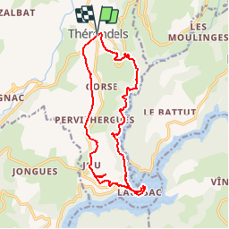
Ruta Senderismo de 17,1 km a descubrir en Occitania, Aveyron, Thérondels. Esta ruta ha sido propuesta por tracegps.
Descripción
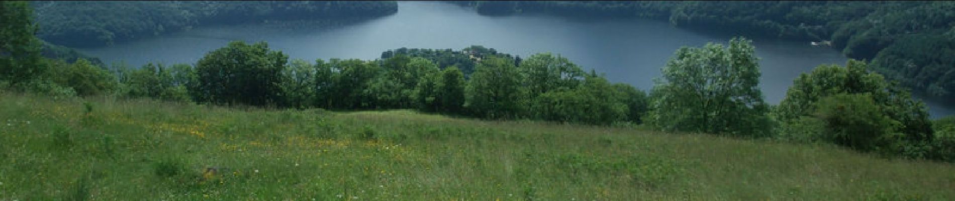
Balade aveyronnaise depuis le village de Thérondels à la limite du Cantal. Un itinéraire varié au soleil et ombragé. Pique-nique à la presqu'ile de Laussac au bord de la retenue du barrage de Sarrans.
Localización
País:
France
Región :
Occitania
Departamento/provincia :
Aveyron
Municipio :
Thérondels
Localidad:
Unknown
Salida:(Dec)
Salida:(UTM)
480901 ; 4971429 (31T) N.
Comentarios
Excursiones cerca
![Excursión Senderismo Thérondels - Thérondels,Nigresserre - Photo](https://media.geolcdn.com/t/375/260/ext.jpg?maxdim=2&url=https%3A%2F%2Fstatic1.geolcdn.com%2Fsiteimages%2Fupload%2Ffiles%2F1553511878bg_sport_marche.png)
![Senderismo Senderismo](https://static1.geolcdn.com/sitytour/trail-icons/101.png)
Thérondels,Nigresserre
Senderismo
Fácil
(1)
Thérondels,
Occitania,
Aveyron,
France
![](/images/other/stat-length.png)
12,7 km | 14,8 km-effort
3h 14min
![](https://static1.geolcdn.com/siteimages/upload/files/16400158638029165_repeat_loop_refresh_sync_direction_icon.png)
No
![Excursión Senderismo Lacapelle-Barrès - puy de Bane - Photo](https://media.geolcdn.com/t/375/260/ext.jpg?maxdim=2&url=https%3A%2F%2Fstatic1.geolcdn.com%2Fsiteimages%2Fupload%2Ffiles%2F1553511878bg_sport_marche.png)
![Senderismo Senderismo](https://static1.geolcdn.com/sitytour/trail-icons/101.png)
puy de Bane
Senderismo
Difícil
Lacapelle-Barrès,
Auvergne-Rhône-Alpes,
Cantal,
France
![](/images/other/stat-length.png)
19,2 km | 26 km-effort
4h 3min
![](https://static1.geolcdn.com/siteimages/upload/files/16400158638029165_repeat_loop_refresh_sync_direction_icon.png)
Sí
![Excursión Senderismo Thérondels - Therondels - Photo](https://media.geolcdn.com/t/375/260/37252885-c645-44e6-a317-8d8420defd3d.jpg&format=jpg&maxdim=2)
![Senderismo Senderismo](https://static1.geolcdn.com/sitytour/trail-icons/101.png)
Therondels
Senderismo
Medio
Thérondels,
Occitania,
Aveyron,
France
![](/images/other/stat-length.png)
15,9 km | 22 km-effort
3h 14min
![](https://static1.geolcdn.com/siteimages/upload/files/16400158638029165_repeat_loop_refresh_sync_direction_icon.png)
Sí
![Excursión Otra actividad Thérondels - Therondels à Pierrefort - Photo](https://media.geolcdn.com/t/375/260/ext.jpg?maxdim=2&url=https%3A%2F%2Fstatic1.geolcdn.com%2Fsiteimages%2Fupload%2Ffiles%2F1545311037marcheuse_200dpi.jpg)
![Otra actividad Otra actividad](https://static1.geolcdn.com/sitytour/trail-icons/900.png)
Therondels à Pierrefort
Otra actividad
Medio
Thérondels,
Occitania,
Aveyron,
France
![](/images/other/stat-length.png)
12,3 km | 17,6 km-effort
4h 21min
![](https://static1.geolcdn.com/siteimages/upload/files/16400158638029165_repeat_loop_refresh_sync_direction_icon.png)
No
![Excursión Senderismo Paulhenc - tersons 13b - Photo](https://media.geolcdn.com/t/375/260/ext.jpg?maxdim=2&url=https%3A%2F%2Fstatic1.geolcdn.com%2Fsiteimages%2Fupload%2Ffiles%2F1553511878bg_sport_marche.png)
![Senderismo Senderismo](https://static1.geolcdn.com/sitytour/trail-icons/101.png)
tersons 13b
Senderismo
Muy fácil
Paulhenc,
Auvergne-Rhône-Alpes,
Cantal,
France
![](/images/other/stat-length.png)
11,4 km | 13,7 km-effort
3h 9min
![](https://static1.geolcdn.com/siteimages/upload/files/16400158638029165_repeat_loop_refresh_sync_direction_icon.png)
No
![Excursión Senderismo Thérondels - THÉRONDELS _ et le paysan créa la prairie 2) - Photo](https://media.geolcdn.com/t/375/260/ext.jpg?maxdim=2&url=https%3A%2F%2Fstatic1.geolcdn.com%2Fsiteimages%2Fupload%2Ffiles%2F1553511878bg_sport_marche.png)
![Senderismo Senderismo](https://static1.geolcdn.com/sitytour/trail-icons/101.png)
THÉRONDELS _ et le paysan créa la prairie 2)
Senderismo
Muy fácil
(1)
Thérondels,
Occitania,
Aveyron,
France
![](/images/other/stat-length.png)
4,1 km | 4,8 km-effort
1h 30min
![](https://static1.geolcdn.com/siteimages/upload/files/16400158638029165_repeat_loop_refresh_sync_direction_icon.png)
Sí
![Excursión Senderismo Paulhenc - la garde-estradié - Photo](https://media.geolcdn.com/t/375/260/ext.jpg?maxdim=2&url=https%3A%2F%2Fstatic1.geolcdn.com%2Fsiteimages%2Fupload%2Ffiles%2F1553511878bg_sport_marche.png)
![Senderismo Senderismo](https://static1.geolcdn.com/sitytour/trail-icons/101.png)
la garde-estradié
Senderismo
Fácil
Paulhenc,
Auvergne-Rhône-Alpes,
Cantal,
France
![](/images/other/stat-length.png)
2,8 km | 3,6 km-effort
59min
![](https://static1.geolcdn.com/siteimages/upload/files/16400158638029165_repeat_loop_refresh_sync_direction_icon.png)
No
![Excursión Senderismo Thérondels - Sentier imaginaire court Therondels - Photo](https://media.geolcdn.com/t/375/260/ext.jpg?maxdim=2&url=https%3A%2F%2Fstatic1.geolcdn.com%2Fsiteimages%2Fupload%2Ffiles%2F1553511878bg_sport_marche.png)
![Senderismo Senderismo](https://static1.geolcdn.com/sitytour/trail-icons/101.png)
Sentier imaginaire court Therondels
Senderismo
Fácil
Thérondels,
Occitania,
Aveyron,
France
![](/images/other/stat-length.png)
3,6 km | 3,9 km-effort
1h 11min
![](https://static1.geolcdn.com/siteimages/upload/files/16400158638029165_repeat_loop_refresh_sync_direction_icon.png)
Sí
![Excursión Senderismo Cantoin - Vines les berges du lac de Sarrans - Photo](https://media.geolcdn.com/t/375/260/ext.jpg?maxdim=2&url=https%3A%2F%2Fstatic1.geolcdn.com%2Fsiteimages%2Fupload%2Ffiles%2F1553511878bg_sport_marche.png)
![Senderismo Senderismo](https://static1.geolcdn.com/sitytour/trail-icons/101.png)
Vines les berges du lac de Sarrans
Senderismo
Difícil
(1)
Cantoin,
Occitania,
Aveyron,
France
![](/images/other/stat-length.png)
11,2 km | 16,4 km-effort
3h 43min
![](https://static1.geolcdn.com/siteimages/upload/files/16400158638029165_repeat_loop_refresh_sync_direction_icon.png)
Sí
Jolie rando. Mise en jambes au départ, longue montée progressive à la fin. Pique nique ou restauration sur place à la presqu’île et baignade possible.