![](/images/other/stat-length.png)
![Excursión Senderismo Ornon - Refuge du Taillefer - Ornon la Grenonière - Photo](https://media.geolcdn.com/t/1900/400/ext.pjpeg?maxdim=2&url=https%3A%2F%2Fservices.sitytrail.com%2FGeolivesWS%2FDownloadMedia.ashx%3FTrailID%3D215213%26Media%3D15827_4.jpg)
Refuge du Taillefer - Ornon la Grenonière
tracegps
Usuario
![Longitud](/images/other/stat-length.png)
Longitud
8,9 km
![Altitud máxima](https://static1.geolcdn.com/siteimages/upload/files/1508320355ic_sort_altitude_max_24dp.png)
Altitud máxima
2041 m
![Desnivel positivo](https://static1.geolcdn.com/siteimages/upload/files/1508320355ic_sort_den_pos_24dp.png)
Desnivel positivo
778 m
![Km-Effort](/images/other/stat-length.png)
Km-Effort
19,2 km
![Altitud mínima](https://static1.geolcdn.com/siteimages/upload/files/1508320355ic_sort_altitude_min_24dp.png)
Altitud mínima
1282 m
![Desnivel negativo](https://static1.geolcdn.com/siteimages/upload/files/1508320355ic_sort_den_neg_24dp.png)
Desnivel negativo
778 m
![Boucle](https://static1.geolcdn.com/siteimages/upload/files/16400158638029165_repeat_loop_refresh_sync_direction_icon.png)
Boucle
Sí
Fecha de creación :
2014-12-10 00:00:00.0
Última modificación :
2014-12-10 00:00:00.0
![Senderismo](https://static1.geolcdn.com/sitytour/trail-icons/101.png)
3h30
Dificultad : Medio
![Escanee este código QR para abrir la excursión en la aplicación SityTrail](https://capi.geolives.com/qq0zvz2zws4bq2lad0pu/sitytour/trails/215213/qr.png?size=200)
Aplicación GPS de excursión GRATIS
A propósito
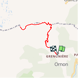
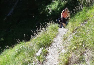
Ruta Senderismo de 8,9 km a descubrir en Auvergne-Rhône-Alpes, Isère, Ornon. Esta ruta ha sido propuesta por tracegps.
Descripción
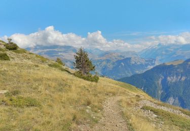
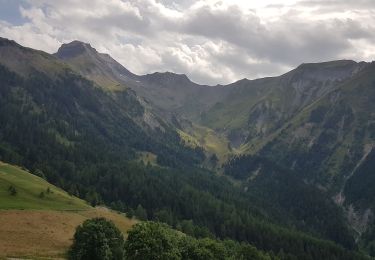
Une fin de montée très agréable dans les alpages. Un beau point de vue sur le col d´Ornon et les massifs environnants.
Localización
País:
France
Región :
Auvergne-Rhône-Alpes
Departamento/provincia :
Isère
Municipio :
Ornon
Localidad:
Unknown
Salida:(Dec)
Salida:(UTM)
734272 ; 4992984 (31T) N.
Comentarios
Excursiones cerca
![Excursión Senderismo Le Bourg-d'Oisans - 38 BG d Oisans cascade pisse - Photo](https://media.geolcdn.com/t/375/260/2e81579a-11c0-4302-b399-8bc55cc0dd5f.jpg&format=jpg&maxdim=2)
![Senderismo Senderismo](https://static1.geolcdn.com/sitytour/trail-icons/101.png)
38 BG d Oisans cascade pisse
Senderismo
Difícil
Le Bourg-d'Oisans,
Auvergne-Rhône-Alpes,
Isère,
France
![](/images/other/stat-length.png)
18,4 km | 36 km-effort
9h 9min
![](https://static1.geolcdn.com/siteimages/upload/files/16400158638029165_repeat_loop_refresh_sync_direction_icon.png)
Sí
![Excursión Esquí de fondo Ornon - Le Taillefer - Photo](https://media.geolcdn.com/t/375/260/c574ba01-aae9-4665-88a5-f41d16e34e2a.jpg&format=jpg&maxdim=2)
![Esquí de fondo Esquí de fondo](https://static1.geolcdn.com/sitytour/trail-icons/503.png)
Le Taillefer
Esquí de fondo
Medio
Ornon,
Auvergne-Rhône-Alpes,
Isère,
France
![](/images/other/stat-length.png)
19,2 km | 40 km-effort
8h 35min
![](https://static1.geolcdn.com/siteimages/upload/files/16400158638029165_repeat_loop_refresh_sync_direction_icon.png)
Sí
![Excursión Esquí de fondo Oulles - Le Grand Galbert - Photo](https://media.geolcdn.com/t/375/260/deb5abfe-9d12-4610-a034-8cf37e109247.jpg&format=jpg&maxdim=2)
![Esquí de fondo Esquí de fondo](https://static1.geolcdn.com/sitytour/trail-icons/503.png)
Le Grand Galbert
Esquí de fondo
Medio
Oulles,
Auvergne-Rhône-Alpes,
Isère,
France
![](/images/other/stat-length.png)
10,2 km | 25 km-effort
5h 7min
![](https://static1.geolcdn.com/siteimages/upload/files/16400158638029165_repeat_loop_refresh_sync_direction_icon.png)
Sí
![Excursión Senderismo Lavaldens - Plancol - Photo](https://media.geolcdn.com/t/375/260/63d19ae2-58d9-4dcc-8f14-cc96c9cea3ad.jpg&format=jpg&maxdim=2)
![Senderismo Senderismo](https://static1.geolcdn.com/sitytour/trail-icons/101.png)
Plancol
Senderismo
Medio
Lavaldens,
Auvergne-Rhône-Alpes,
Isère,
France
![](/images/other/stat-length.png)
10,6 km | 19,3 km-effort
5h 6min
![](https://static1.geolcdn.com/siteimages/upload/files/16400158638029165_repeat_loop_refresh_sync_direction_icon.png)
Sí
![Excursión Senderismo Ornon - Plateau des lacs - Photo](https://media.geolcdn.com/t/375/260/95c91083-32aa-44d3-b116-e3d30f3c6317.jpg&format=jpg&maxdim=2)
![Senderismo Senderismo](https://static1.geolcdn.com/sitytour/trail-icons/101.png)
Plateau des lacs
Senderismo
Difícil
Ornon,
Auvergne-Rhône-Alpes,
Isère,
France
![](/images/other/stat-length.png)
15,8 km | 27 km-effort
7h 19min
![](https://static1.geolcdn.com/siteimages/upload/files/16400158638029165_repeat_loop_refresh_sync_direction_icon.png)
Sí
![Excursión Senderismo Villard-Reymond - La Croix du Carrelet et la crête de Croix de La Garde - Photo](https://media.geolcdn.com/t/375/260/719f71c8-5764-4d7d-9547-f0e72ea0e1f5.jpg&format=jpg&maxdim=2)
![Senderismo Senderismo](https://static1.geolcdn.com/sitytour/trail-icons/101.png)
La Croix du Carrelet et la crête de Croix de La Garde
Senderismo
Medio
Villard-Reymond,
Auvergne-Rhône-Alpes,
Isère,
France
![](/images/other/stat-length.png)
9,9 km | 18,2 km-effort
5h 38min
![](https://static1.geolcdn.com/siteimages/upload/files/16400158638029165_repeat_loop_refresh_sync_direction_icon.png)
No
![Excursión Senderismo Le Bourg-d'Oisans - Bourg d'Oisans les cascades - Photo](https://media.geolcdn.com/t/375/260/f162be93-5b19-484b-970f-69f2c59af7f2.jpg&format=jpg&maxdim=2)
![Senderismo Senderismo](https://static1.geolcdn.com/sitytour/trail-icons/101.png)
Bourg d'Oisans les cascades
Senderismo
Difícil
Le Bourg-d'Oisans,
Auvergne-Rhône-Alpes,
Isère,
France
![](/images/other/stat-length.png)
19,1 km | 37 km-effort
9h 0min
![](https://static1.geolcdn.com/siteimages/upload/files/16400158638029165_repeat_loop_refresh_sync_direction_icon.png)
Sí
![Excursión Senderismo Ornon - Plateau des lacs, lac Fourchu. par bergerie - Photo](https://media.geolcdn.com/t/375/260/96726bb9-ed4e-493b-a6c3-1add5f355935.jpg&format=jpg&maxdim=2)
![Senderismo Senderismo](https://static1.geolcdn.com/sitytour/trail-icons/101.png)
Plateau des lacs, lac Fourchu. par bergerie
Senderismo
Medio
Ornon,
Auvergne-Rhône-Alpes,
Isère,
France
![](/images/other/stat-length.png)
12,8 km | 23 km-effort
6h 22min
![](https://static1.geolcdn.com/siteimages/upload/files/16400158638029165_repeat_loop_refresh_sync_direction_icon.png)
Sí
![Excursión Senderismo Villard-Notre-Dame - villard Redmond - Photo](https://media.geolcdn.com/t/375/260/06639bd3-b0d9-4d0a-b2aa-40bb1a3232fe.jpg&format=jpg&maxdim=2)
![Senderismo Senderismo](https://static1.geolcdn.com/sitytour/trail-icons/101.png)
villard Redmond
Senderismo
Muy fácil
Villard-Notre-Dame,
Auvergne-Rhône-Alpes,
Isère,
France
![](/images/other/stat-length.png)
7,2 km | 11,3 km-effort
4h 32min
![](https://static1.geolcdn.com/siteimages/upload/files/16400158638029165_repeat_loop_refresh_sync_direction_icon.png)
No