![](/images/other/stat-length.png)
![Excursión Senderismo Fontainebleau - Parcours Montagne de Franchard-Cuisinière - Photo](https://media.geolcdn.com/t/1900/400/ext.pjpeg?maxdim=2&url=https%3A%2F%2Fservices.sitytrail.com%2FGeolivesWS%2FDownloadMedia.ashx%3FTrailID%3D215039%26Media%3D15609_6.jpg)
Parcours Montagne de Franchard-Cuisinière
tracegps
Usuario
![Longitud](/images/other/stat-length.png)
![Altitud máxima](https://static1.geolcdn.com/siteimages/upload/files/1508320355ic_sort_altitude_max_24dp.png)
![Desnivel positivo](https://static1.geolcdn.com/siteimages/upload/files/1508320355ic_sort_den_pos_24dp.png)
![Km-Effort](/images/other/stat-length.png)
![Altitud mínima](https://static1.geolcdn.com/siteimages/upload/files/1508320355ic_sort_altitude_min_24dp.png)
![Desnivel negativo](https://static1.geolcdn.com/siteimages/upload/files/1508320355ic_sort_den_neg_24dp.png)
![Boucle](https://static1.geolcdn.com/siteimages/upload/files/16400158638029165_repeat_loop_refresh_sync_direction_icon.png)
![Senderismo](https://static1.geolcdn.com/sitytour/trail-icons/101.png)
7h00
Dificultad : Muy difícil
![Escanee este código QR para abrir la excursión en la aplicación SityTrail](https://capi.geolives.com/qq0zvz2zws4bq2lad0pu/sitytour/trails/215039/qr.png?size=200)
Aplicación GPS de excursión GRATIS
A propósito
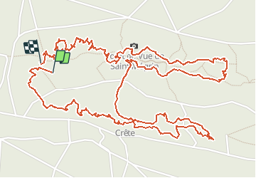
Ruta Senderismo de 5 km a descubrir en Isla de Francia, Sena y Marne, Fontainebleau. Esta ruta ha sido propuesta por tracegps.
Descripción
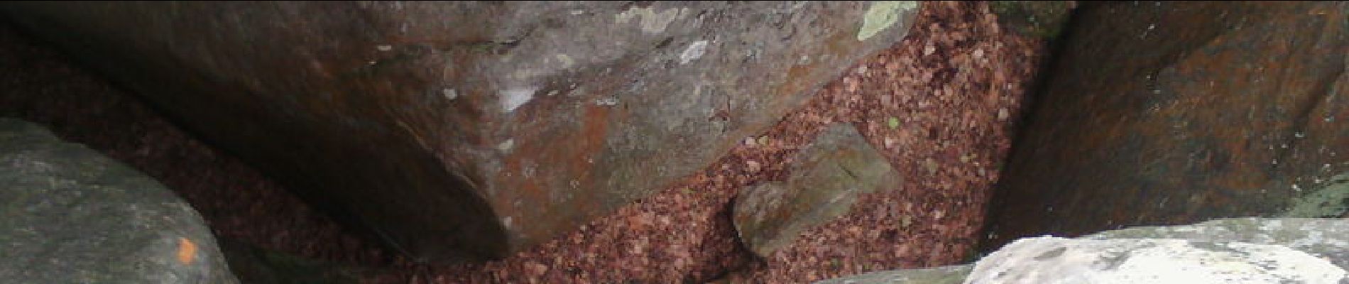
Ce parcours est originellement tracé en couleur "cerise" cf: "La Cerise du Débutant". Désormais on l’appelle "Parcours Montagne de Franchard-Cuisinière". Il a été tracé en 1960 par le CAF (Club Alpin Français et non la caisse d'allocation familiale :)) animé par Jacques Meynieu. Ce circuit est un très très bon entrainement à la course en montagne, on ne fait que escalader, désescalader, ramper, sauter de bloc en bloc parfois marcher :). Bref cette balade ascensionnelle n'est pas faite pour les néophytes de la verticalité, de plus les chutes peuvent être très dangereuses en cas de glissade. Bonne ascension en pays Bleausard
Localización
Comentarios
Excursiones cerca
![Excursión Senderismo Barbizon - Sentier des peintres - Photo](https://media.geolcdn.com/t/375/260/ext.jpg?maxdim=2&url=https%3A%2F%2Fservices.sitytrail.com%2FGeolivesWS%2FDownloadMedia.ashx%3FTrailID%3D188736%26Media%3D187396bd-9ee4-4169-9310-5793d2588587.jpeg)
![Senderismo Senderismo](https://static1.geolcdn.com/sitytour/trail-icons/101.png)
Senderismo
![](/images/other/stat-length.png)
![](https://static1.geolcdn.com/siteimages/upload/files/16400158638029165_repeat_loop_refresh_sync_direction_icon.png)
![Excursión Senderismo Fontainebleau - 3pi-150428 - DésertApremont-Jupiter - Photo](https://media.geolcdn.com/t/375/260/ext.jpg?maxdim=2&url=https%3A%2F%2Fservices.sitytrail.com%2FGeolivesWS%2FDownloadMedia.ashx%3FTrailID%3D414037%26Media%3D22942274-9308-46bb-bc6d-06c82c3e8751.jpg)
![Senderismo Senderismo](https://static1.geolcdn.com/sitytour/trail-icons/101.png)
Senderismo
![](/images/other/stat-length.png)
![](https://static1.geolcdn.com/siteimages/upload/files/16400158638029165_repeat_loop_refresh_sync_direction_icon.png)
![Excursión Senderismo Noisy-sur-École - M&R-121118 - 250Marches - Photo](https://media.geolcdn.com/t/375/260/ext.jpg?maxdim=2&url=https%3A%2F%2Fservices.sitytrail.com%2FGeolivesWS%2FDownloadMedia.ashx%3FTrailID%3D163348%26Media%3D20121118101634.jpeg)
![Senderismo Senderismo](https://static1.geolcdn.com/sitytour/trail-icons/101.png)
Senderismo
![](/images/other/stat-length.png)
![](https://static1.geolcdn.com/siteimages/upload/files/16400158638029165_repeat_loop_refresh_sync_direction_icon.png)
![Excursión Senderismo Noisy-sur-École - Bois Rond#4 - Photo](https://media.geolcdn.com/t/375/260/7321184d-880d-445f-98b4-47f0ff0d82dd.jpg&format=jpg&maxdim=2)
![Senderismo Senderismo](https://static1.geolcdn.com/sitytour/trail-icons/101.png)
Senderismo
![](/images/other/stat-length.png)
![](https://static1.geolcdn.com/siteimages/upload/files/16400158638029165_repeat_loop_refresh_sync_direction_icon.png)
![Excursión Senderismo Fontainebleau - Boucle Barbizon - Arbonne 26 km - Photo](https://media.geolcdn.com/t/375/260/d3a133ff-ea77-47a6-826a-54bbe45391c4.jpg&format=jpg&maxdim=2)
![Senderismo Senderismo](https://static1.geolcdn.com/sitytour/trail-icons/101.png)
Senderismo
![](/images/other/stat-length.png)
![](https://static1.geolcdn.com/siteimages/upload/files/16400158638029165_repeat_loop_refresh_sync_direction_icon.png)
![Excursión Senderismo Noisy-sur-École - Boucle 24 km Fontainebleau Arbonne - Photo](https://media.geolcdn.com/t/375/260/5aaa62f0-dc57-4770-a77a-231413885a94.jpg&format=jpg&maxdim=2)
![Senderismo Senderismo](https://static1.geolcdn.com/sitytour/trail-icons/101.png)
Senderismo
![](/images/other/stat-length.png)
![](https://static1.geolcdn.com/siteimages/upload/files/16400158638029165_repeat_loop_refresh_sync_direction_icon.png)
![Excursión Senderismo Noisy-sur-École - Noisy sur Ecole / Coquibus - Photo](https://media.geolcdn.com/t/375/260/9f6ffc55-2cbc-4988-8e49-be93fd15ba38.jpg&format=jpg&maxdim=2)
![Senderismo Senderismo](https://static1.geolcdn.com/sitytour/trail-icons/101.png)
Senderismo
![](/images/other/stat-length.png)
![](https://static1.geolcdn.com/siteimages/upload/files/16400158638029165_repeat_loop_refresh_sync_direction_icon.png)
![Excursión A pie Fontainebleau - SityTrail - JC 60 Fontainebleau, les rochers du long boyau, du Mt Morillon, des Demoiselles... - Photo](https://media.geolcdn.com/t/375/260/ext.jpg?maxdim=2&url=https%3A%2F%2Fstatic1.geolcdn.com%2Fsiteimages%2Fupload%2Ffiles%2F1545311037marcheuse_200dpi.jpg)
![A pie A pie](https://static1.geolcdn.com/sitytour/trail-icons/100.png)
A pie
![](/images/other/stat-length.png)
![](https://static1.geolcdn.com/siteimages/upload/files/16400158638029165_repeat_loop_refresh_sync_direction_icon.png)
![Excursión Senderismo Barbizon - Le tour du Grand Paris via le GR1 etape 14 Barbizon- Malesherbes - Photo](https://media.geolcdn.com/t/375/260/8af1b7ac-6c06-4a51-9474-d487076c1a9a.jpg&format=jpg&maxdim=2)
![Senderismo Senderismo](https://static1.geolcdn.com/sitytour/trail-icons/101.png)
Senderismo
![](/images/other/stat-length.png)
![](https://static1.geolcdn.com/siteimages/upload/files/16400158638029165_repeat_loop_refresh_sync_direction_icon.png)