![](/images/other/stat-length.png)
![Excursión Senderismo Yvoir - RB-Na-03 Raccourci 1&2 - Forteresses, citadelle et abbaye mosanes - Photo](https://media.geolcdn.com/t/1900/400/ext.pjpeg?maxdim=2&url=https%3A%2F%2Fservices.sitytrail.com%2FGeolivesWS%2FDownloadMedia.ashx%3FTrailID%3D213750%26Media%3D37c79d95-1fdd-4203-82dc-2c4901c9d46c.jpg)
RB-Na-03 Raccourci 1&2 - Forteresses, citadelle et abbaye mosanes
GR Rando
Randonnez sur et autour des GR ® wallons (Sentiers de Grande Randonnée). PRO
![Longitud](/images/other/stat-length.png)
![Altitud máxima](https://static1.geolcdn.com/siteimages/upload/files/1508320355ic_sort_altitude_max_24dp.png)
![Desnivel positivo](https://static1.geolcdn.com/siteimages/upload/files/1508320355ic_sort_den_pos_24dp.png)
![Km-Effort](/images/other/stat-length.png)
![Altitud mínima](https://static1.geolcdn.com/siteimages/upload/files/1508320355ic_sort_altitude_min_24dp.png)
![Desnivel negativo](https://static1.geolcdn.com/siteimages/upload/files/1508320355ic_sort_den_neg_24dp.png)
![Boucle](https://static1.geolcdn.com/siteimages/upload/files/16400158638029165_repeat_loop_refresh_sync_direction_icon.png)
![Senderismo](https://static1.geolcdn.com/sitytour/trail-icons/101.png)
5h33
Dificultad : Fácil
![Escanee este código QR para abrir la excursión en la aplicación SityTrail](https://capi.geolives.com/qq0zvz2zws4bq2lad0pu/sitytour/trails/213750/qr.png?size=200)
Aplicación GPS de excursión GRATIS
A propósito
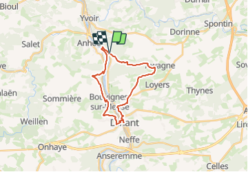
Ruta Senderismo de 20 km a descubrir en Valonia, Namur, Yvoir. Esta ruta ha sido propuesta por GR Rando.
Descripción
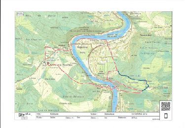
Houx – Dinant – Bouvignes – Houx
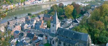
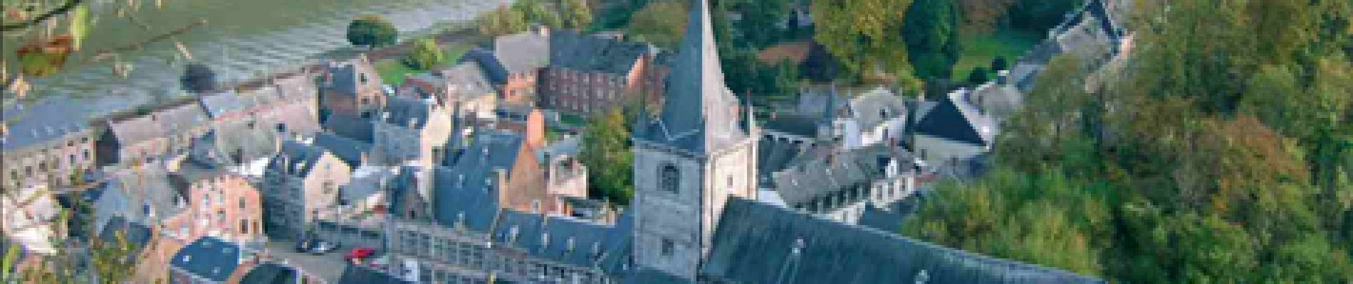
Cet itinéraire se révèle à la fois panoramique et culturel. Entre Dinant et Namur, en effet, la Meuse est bordée de hautes collines. Depuis le Moyen Âge, ces pitons rocheux ont accueilli des forteresses, dont le randonneur côtoiera les vestiges ou les aménagements ultérieurs. Ces éminences constituent aussi autant de belvédères naturels qu’il faut mériter à la force du jarret. Au fond de la vallée mosane, Dinant, Bouvignes et Leffe recèlent encore des monuments architecturaux, religieux et civils, témoins de leur opulence passée.
Cartographie et documentation:
Cartes IGN au 1 : 20 000, 53/3-4 « Anhée – Yvoir » et 53/7-8 « Hastière – Dinant ».
Carte « Promenades de Dinant et de ses anciennes communes » au 1 : 25 000, éditée par le Syndicat d’Initiative de Dinant en collaboration avec l’IGN.
Carte « Promenades d’Anhée » au 1 : 25 000, éditée par le Syndicat d’Initiative d’Anhée en collaboration avec l’IGN.
Topo-guides des GR 125 « Tour de l’Entre-Sambre-et-Meuse », GR 126 « Bruxelles – Namur – Membre-sur-Semois », GR 129 « La Belgique en diagonale, tronçon Ellezelles – Mons – Dinant ».
Où se désaltérer et se restaurer :
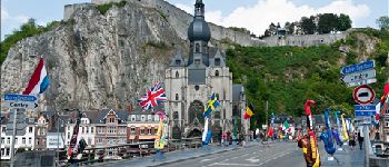
À Leffe, bistrot à deux pas de l’abbaye. Sur le site de la citadelle de Dinant, 50 mètres à droite à l’écart du GR, la taverne voisine du cimetière militaire est accueillante pour les randonneurs.
À Dinant, bien sûr, cafés, restaurants et hôtels. Le randonneur qui désire y faire halte aura intérêt à passer le pont : le quartier de la gare évite un tant soit peu la foule touristique du bord de Meuse. En fin de parcours, l’auberge de Bouvignes, très accueillante, pratique des prix très démocratiques.
Localización
Comentarios
Excursiones cerca
![Excursión Senderismo Yvoir - RB-Na-03 Forteresses, citadelle et abbaye mosanes - Photo](https://media.geolcdn.com/t/375/260/ext.jpg?maxdim=2&url=https%3A%2F%2Fservices.sitytrail.com%2FGeolivesWS%2FDownloadMedia.ashx%3FTrailID%3D179628%26Media%3D8266bb1a-850d-41b8-8bad-8e0bd7c82bf9.jpg)
![Senderismo Senderismo](https://static1.geolcdn.com/sitytour/trail-icons/101.png)
Senderismo
![](/images/other/stat-length.png)
![](https://static1.geolcdn.com/siteimages/upload/files/16400158638029165_repeat_loop_refresh_sync_direction_icon.png)
![Excursión Senderismo Anhée - RF-Na-05 Annevoie, côté Jardins_Grande-boucle - Photo](https://media.geolcdn.com/t/375/260/ext.jpg?maxdim=2&url=https%3A%2F%2Fservices.sitytrail.com%2FGeolivesWS%2FDownloadMedia.ashx%3FTrailID%3D545753%26Media%3D5d973c83-4a6c-40fc-a026-25de6c754887.JPG)
![Senderismo Senderismo](https://static1.geolcdn.com/sitytour/trail-icons/101.png)
Senderismo
![](/images/other/stat-length.png)
![](https://static1.geolcdn.com/siteimages/upload/files/16400158638029165_repeat_loop_refresh_sync_direction_icon.png)
![Excursión Senderismo Anhée - RF-Na-05 Annevoie, côté Jardins_Petite-boucle - Photo](https://media.geolcdn.com/t/375/260/ext.jpg?maxdim=2&url=https%3A%2F%2Fservices.sitytrail.com%2FGeolivesWS%2FDownloadMedia.ashx%3FTrailID%3D545751%26Media%3D5d973c83-4a6c-40fc-a026-25de6c754887.JPG)
![Senderismo Senderismo](https://static1.geolcdn.com/sitytour/trail-icons/101.png)
Senderismo
![](/images/other/stat-length.png)
![](https://static1.geolcdn.com/siteimages/upload/files/16400158638029165_repeat_loop_refresh_sync_direction_icon.png)
![Excursión Senderismo Dinant - Balade à Dinant - La Réserve Naturelle de Moniat - Photo](https://media.geolcdn.com/t/375/260/765b9b62-b29c-4537-9ff6-9d29c15be9d8.jpg&format=jpg&maxdim=2)
![Senderismo Senderismo](https://static1.geolcdn.com/sitytour/trail-icons/101.png)
Senderismo
![](/images/other/stat-length.png)
![](https://static1.geolcdn.com/siteimages/upload/files/16400158638029165_repeat_loop_refresh_sync_direction_icon.png)
![Excursión Senderismo Yvoir - D'Yvoir à Evrehailles - Photo](https://media.geolcdn.com/t/375/260/ext.jpg?maxdim=2&url=https%3A%2F%2Fservices.sitytrail.com%2FGeolivesWS%2FDownloadMedia.ashx%3FTrailID%3D406377%26Media%3Ddbb536c7-63fc-4c6a-9524-770626f70bd4.JPG)
![Senderismo Senderismo](https://static1.geolcdn.com/sitytour/trail-icons/101.png)
Senderismo
![](/images/other/stat-length.png)
![](https://static1.geolcdn.com/siteimages/upload/files/16400158638029165_repeat_loop_refresh_sync_direction_icon.png)
![Excursión Senderismo Dinant - Balade à Bouvignes - Photo](https://media.geolcdn.com/t/375/260/ext.jpg?maxdim=2&url=https%3A%2F%2Fservices.sitytrail.com%2FGeolivesWS%2FDownloadMedia.ashx%3FTrailID%3D223072%26Media%3D8dae2923-6a84-4680-856b-d65e95092209.JPG)
![Senderismo Senderismo](https://static1.geolcdn.com/sitytour/trail-icons/101.png)
Senderismo
![](/images/other/stat-length.png)
![](https://static1.geolcdn.com/siteimages/upload/files/16400158638029165_repeat_loop_refresh_sync_direction_icon.png)
![Excursión Senderismo Dinant - Balade en Réserve Naturelle de Devant Bouvignes - Photo](https://media.geolcdn.com/t/375/260/ext.jpg?maxdim=2&url=https%3A%2F%2Fservices.sitytrail.com%2FGeolivesWS%2FDownloadMedia.ashx%3FTrailID%3D222999%26Media%3D231bd4cd-9ad4-4a88-bcf6-84f0725ce446.JPG)
![Senderismo Senderismo](https://static1.geolcdn.com/sitytour/trail-icons/101.png)
Senderismo
![](/images/other/stat-length.png)
![](https://static1.geolcdn.com/siteimages/upload/files/16400158638029165_repeat_loop_refresh_sync_direction_icon.png)
![Excursión Senderismo Anhée - D''Annevoie à Godinne par les Rochers de Finevoie - Photo](https://media.geolcdn.com/t/375/260/ext.jpg?maxdim=2&url=https%3A%2F%2Fservices.sitytrail.com%2FGeolivesWS%2FDownloadMedia.ashx%3FTrailID%3D197717%26Media%3Df5c7b5a4-c57b-45f8-873a-78580654795d.jpg)
![Senderismo Senderismo](https://static1.geolcdn.com/sitytour/trail-icons/101.png)
Senderismo
![](/images/other/stat-length.png)
![](https://static1.geolcdn.com/siteimages/upload/files/16400158638029165_repeat_loop_refresh_sync_direction_icon.png)
![Excursión Senderismo Anhée - rando ornitho haut le wastia 01/04/2021 - Photo](https://media.geolcdn.com/t/375/260/6351cc8d-4bd0-44ad-b76a-97c195daeb77.jpg&format=jpg&maxdim=2)
![Senderismo Senderismo](https://static1.geolcdn.com/sitytour/trail-icons/101.png)
Senderismo
![](/images/other/stat-length.png)
![](https://static1.geolcdn.com/siteimages/upload/files/16400158638029165_repeat_loop_refresh_sync_direction_icon.png)