![](/images/other/stat-length.png)
![Excursión Senderismo Maasmechelen - Maasmechelen - Photo](https://media.geolcdn.com/t/1900/400/ext.pjpeg?maxdim=2&url=https%3A%2F%2Fstatic1.geolcdn.com%2Fsiteimages%2Fupload%2Ffiles%2F1553511878bg_sport_marche.png)
Maasmechelen
flip96
Usuario
![Longitud](/images/other/stat-length.png)
Longitud
17,2 km
![Altitud máxima](https://static1.geolcdn.com/siteimages/upload/files/1508320355ic_sort_altitude_max_24dp.png)
Altitud máxima
101 m
![Desnivel positivo](https://static1.geolcdn.com/siteimages/upload/files/1508320355ic_sort_den_pos_24dp.png)
Desnivel positivo
173 m
![Km-Effort](/images/other/stat-length.png)
Km-Effort
19,5 km
![Altitud mínima](https://static1.geolcdn.com/siteimages/upload/files/1508320355ic_sort_altitude_min_24dp.png)
Altitud mínima
48 m
![Desnivel negativo](https://static1.geolcdn.com/siteimages/upload/files/1508320355ic_sort_den_neg_24dp.png)
Desnivel negativo
173 m
![Boucle](https://static1.geolcdn.com/siteimages/upload/files/16400158638029165_repeat_loop_refresh_sync_direction_icon.png)
Boucle
Sí
Fecha de creación :
2014-12-10 00:00:00.0
Última modificación :
2014-12-10 00:00:00.0
![Senderismo](https://static1.geolcdn.com/sitytour/trail-icons/101.png)
4h20
Dificultad : Fácil
![Escanee este código QR para abrir la excursión en la aplicación SityTrail](https://capi.geolives.com/qq0zvz2zws4bq2lad0pu/sitytour/trails/213742/qr.png?size=200)
Aplicación GPS de excursión GRATIS
A propósito
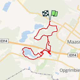
Ruta Senderismo de 17,2 km a descubrir en Flandes, Limburgo, Maasmechelen. Esta ruta ha sido propuesta por flip96.
Descripción
Rondwandeling op de Mechelse Heide. Vanuit Maasmechelen, Poort Nationale Park K5 (Joseph Smeetslaan 280 Maasmechelen).
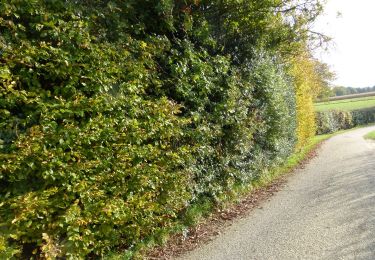
Mooie, eenvoudige wandeling met in augustus/september bloeiende heide.
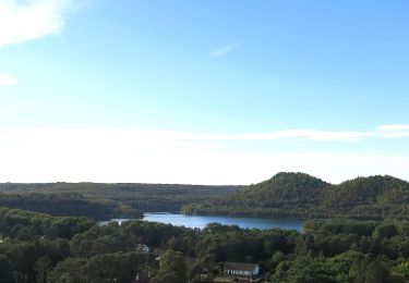
Prachtige waterplassen in voormalige zandgroeve.
Opmerkingen? flip96@home.nl
Localización
País:
Belgium
Región :
Flandes
Departamento/provincia :
Limburgo
Municipio :
Maasmechelen
Localidad:
Mechelen-aan-de-Maas
Salida:(Dec)
Salida:(UTM)
686663 ; 5650755 (31U) N.
Comentarios
Excursiones cerca
![Excursión Senderismo Maasmechelen - Mechelse Heide - Photo](https://media.geolcdn.com/t/375/260/501f02e9-8086-4be8-98c9-f01120ddee06.jpg&format=jpg&maxdim=2)
![Senderismo Senderismo](https://static1.geolcdn.com/sitytour/trail-icons/101.png)
Mechelse Heide
Senderismo
Fácil
(2)
Maasmechelen,
Flandes,
Limburgo,
Belgium
![](/images/other/stat-length.png)
14,2 km | 16,2 km-effort
3h 41min
![](https://static1.geolcdn.com/siteimages/upload/files/16400158638029165_repeat_loop_refresh_sync_direction_icon.png)
Sí
![Excursión A pie As - Mechelse Heide Noord - Photo](https://media.geolcdn.com/t/375/260/6c3d6be9-86c4-472e-82c2-64c07d2c49aa.jpeg&format=jpg&maxdim=2)
![A pie A pie](https://static1.geolcdn.com/sitytour/trail-icons/100.png)
![Excursión A pie Maasmechelen - Erfgoedwandeling Eisden Tuinwijk - Photo](https://media.geolcdn.com/t/375/260/28db0122-7bbc-4a11-ae3a-faea898e04f5.jpeg&format=jpg&maxdim=2)
![A pie A pie](https://static1.geolcdn.com/sitytour/trail-icons/100.png)
Erfgoedwandeling Eisden Tuinwijk
A pie
Fácil
Maasmechelen,
Flandes,
Limburgo,
Belgium
![](/images/other/stat-length.png)
3,1 km | 3,3 km-effort
44min
![](https://static1.geolcdn.com/siteimages/upload/files/16400158638029165_repeat_loop_refresh_sync_direction_icon.png)
Sí
![Excursión A pie Dilsen-Stokkem - Connecterra Rode driehoek - Photo](https://media.geolcdn.com/t/375/260/5eb5c103-eb27-4a59-83d3-dfd2672ebb0c.jpeg&format=jpg&maxdim=2)
![A pie A pie](https://static1.geolcdn.com/sitytour/trail-icons/100.png)
Connecterra Rode driehoek
A pie
Fácil
Dilsen-Stokkem,
Flandes,
Limburgo,
Belgium
![](/images/other/stat-length.png)
6,2 km | 7 km-effort
1h 35min
![](https://static1.geolcdn.com/siteimages/upload/files/16400158638029165_repeat_loop_refresh_sync_direction_icon.png)
No
![Excursión A pie Maasmechelen - Station As Groene rechthoek - Photo](https://media.geolcdn.com/t/375/260/6c3d6be9-86c4-472e-82c2-64c07d2c49aa.jpeg&format=jpg&maxdim=2)
![A pie A pie](https://static1.geolcdn.com/sitytour/trail-icons/100.png)
Station As Groene rechthoek
A pie
Fácil
Maasmechelen,
Flandes,
Limburgo,
Belgium
![](/images/other/stat-length.png)
3,3 km | 3,8 km-effort
51min
![](https://static1.geolcdn.com/siteimages/upload/files/16400158638029165_repeat_loop_refresh_sync_direction_icon.png)
Sí
![Excursión A pie Maasmechelen - Leut & Meeswijk Gele zeshoek - Photo](https://media.geolcdn.com/t/375/260/3a349166-7856-4cc9-a007-a2d01b733e80.jpeg&format=jpg&maxdim=2)
![A pie A pie](https://static1.geolcdn.com/sitytour/trail-icons/100.png)
Leut & Meeswijk Gele zeshoek
A pie
Fácil
Maasmechelen,
Flandes,
Limburgo,
Belgium
![](/images/other/stat-length.png)
7 km | 7,4 km-effort
1h 40min
![](https://static1.geolcdn.com/siteimages/upload/files/16400158638029165_repeat_loop_refresh_sync_direction_icon.png)
Sí
![Excursión A pie Maasmechelen - Station As Blauwe ruit - Photo](https://media.geolcdn.com/t/375/260/6c3d6be9-86c4-472e-82c2-64c07d2c49aa.jpeg&format=jpg&maxdim=2)
![A pie A pie](https://static1.geolcdn.com/sitytour/trail-icons/100.png)
Station As Blauwe ruit
A pie
Fácil
Maasmechelen,
Flandes,
Limburgo,
Belgium
![](/images/other/stat-length.png)
6,5 km | 7,1 km-effort
1h 36min
![](https://static1.geolcdn.com/siteimages/upload/files/16400158638029165_repeat_loop_refresh_sync_direction_icon.png)
Sí
![Excursión A pie Maasmechelen - Station As Rode driehoek - Photo](https://media.geolcdn.com/t/375/260/6649a029-f07f-4f45-b4d8-2b574463e7fd.jpeg&format=jpg&maxdim=2)
![A pie A pie](https://static1.geolcdn.com/sitytour/trail-icons/100.png)
Station As Rode driehoek
A pie
Fácil
Maasmechelen,
Flandes,
Limburgo,
Belgium
![](/images/other/stat-length.png)
12 km | 13,4 km-effort
3h 3min
![](https://static1.geolcdn.com/siteimages/upload/files/16400158638029165_repeat_loop_refresh_sync_direction_icon.png)
Sí
![Excursión A pie Dilsen-Stokkem - Litzberg groene rechthoek - Photo](https://media.geolcdn.com/t/375/260/085d16b1-ffd1-4281-a4d3-38ce31d4ff24.jpeg&format=jpg&maxdim=2)
![A pie A pie](https://static1.geolcdn.com/sitytour/trail-icons/100.png)
Litzberg groene rechthoek
A pie
Fácil
Dilsen-Stokkem,
Flandes,
Limburgo,
Belgium
![](/images/other/stat-length.png)
3 km | 3,7 km-effort
49min
![](https://static1.geolcdn.com/siteimages/upload/files/16400158638029165_repeat_loop_refresh_sync_direction_icon.png)
Sí