![](/images/other/stat-length.png)
![Excursión Senderismo Tignes - Tignes 1800 lac de la Sassièrre aller-retour - Photo](https://media.geolcdn.com/t/1900/400/ae37ca96-9517-4fd4-82f6-2f8c10f3622c.jpg&format=pjpeg&maxdim=2)
Tignes 1800 lac de la Sassièrre aller-retour
phdsyn
Usuario
![Longitud](/images/other/stat-length.png)
Longitud
28 km
![Altitud máxima](https://static1.geolcdn.com/siteimages/upload/files/1508320355ic_sort_altitude_max_24dp.png)
Altitud máxima
2768 m
![Desnivel positivo](https://static1.geolcdn.com/siteimages/upload/files/1508320355ic_sort_den_pos_24dp.png)
Desnivel positivo
1409 m
![Km-Effort](/images/other/stat-length.png)
Km-Effort
47 km
![Altitud mínima](https://static1.geolcdn.com/siteimages/upload/files/1508320355ic_sort_altitude_min_24dp.png)
Altitud mínima
1666 m
![Desnivel negativo](https://static1.geolcdn.com/siteimages/upload/files/1508320355ic_sort_den_neg_24dp.png)
Desnivel negativo
1408 m
![Boucle](https://static1.geolcdn.com/siteimages/upload/files/16400158638029165_repeat_loop_refresh_sync_direction_icon.png)
Boucle
Sí
Fecha de creación :
2019-07-02 09:06:58.593
Última modificación :
2019-07-03 13:14:37.934
![Senderismo](https://static1.geolcdn.com/sitytour/trail-icons/101.png)
1h00
Dificultad : Medio
![Bici de montaña](https://static1.geolcdn.com/sitytour/trail-icons/202.png)
4h37
Dificultad : Medio
![Escanee este código QR para abrir la excursión en la aplicación SityTrail](https://capi.geolives.com/qq0zvz2zws4bq2lad0pu/sitytour/trails/2129373/qr.png?size=200)
Aplicación GPS de excursión GRATIS
A propósito
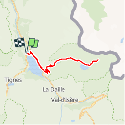
Ruta Senderismo de 28 km a descubrir en Auvergne-Rhône-Alpes, Saboya, Tignes. Esta ruta ha sido propuesta por phdsyn.
Descripción
Depuis l'arrêt de bus de Tignes 1800 jusque au glacier de Santel.
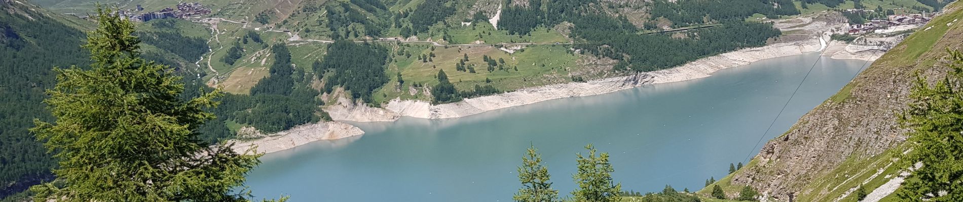
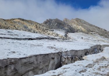
Après le lac de Santel au bout du chemin, on passe en mode marche.
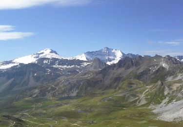
l'utilisation de bâtons est vivement conseillée.
Localización
País:
France
Región :
Auvergne-Rhône-Alpes
Departamento/provincia :
Saboya
Municipio :
Tignes
Localidad:
Unknown
Salida:(Dec)
Salida:(UTM)
338033 ; 5040063 (32T) N.
Comentarios
Excursiones cerca
![Excursión Senderismo Tignes - la pointe de Picheru - Photo](https://media.geolcdn.com/t/375/260/ext.jpg?maxdim=2&url=https%3A%2F%2Fservices.sitytrail.com%2FGeolivesWS%2FDownloadMedia.ashx%3FTrailID%3D813856%26Media%3Dfix__20170820100255.jpg)
![Senderismo Senderismo](https://static1.geolcdn.com/sitytour/trail-icons/101.png)
la pointe de Picheru
Senderismo
Medio
(1)
Tignes,
Auvergne-Rhône-Alpes,
Saboya,
France
![](/images/other/stat-length.png)
13,8 km | 23 km-effort
5h 36min
![](https://static1.geolcdn.com/siteimages/upload/files/16400158638029165_repeat_loop_refresh_sync_direction_icon.png)
Sí
![Excursión Senderismo Tignes - l'aiguille perçée - Photo](https://media.geolcdn.com/t/375/260/ext.jpg?maxdim=2&url=https%3A%2F%2Fservices.sitytrail.com%2FGeolivesWS%2FDownloadMedia.ashx%3FTrailID%3D337133%26Media%3Dfix__20140820112508.jpg)
![Senderismo Senderismo](https://static1.geolcdn.com/sitytour/trail-icons/101.png)
l'aiguille perçée
Senderismo
Fácil
(1)
Tignes,
Auvergne-Rhône-Alpes,
Saboya,
France
![](/images/other/stat-length.png)
5,8 km | 9,8 km-effort
3h 27min
![](https://static1.geolcdn.com/siteimages/upload/files/16400158638029165_repeat_loop_refresh_sync_direction_icon.png)
No
![Excursión Senderismo Tignes - lacs du saut et de la sassiere - Photo](https://media.geolcdn.com/t/375/260/ext.jpg?maxdim=2&url=https%3A%2F%2Fservices.sitytrail.com%2FGeolivesWS%2FDownloadMedia.ashx%3FTrailID%3D336967%26Media%3D637041f5-cff1-4406-a972-10b75ef104dd.JPG)
![Senderismo Senderismo](https://static1.geolcdn.com/sitytour/trail-icons/101.png)
lacs du saut et de la sassiere
Senderismo
Muy fácil
(3)
Tignes,
Auvergne-Rhône-Alpes,
Saboya,
France
![](/images/other/stat-length.png)
9 km | 12,6 km-effort
3h 56min
![](https://static1.geolcdn.com/siteimages/upload/files/16400158638029165_repeat_loop_refresh_sync_direction_icon.png)
Sí
![Excursión Otra actividad Tignes - Refuge du Palet Col de la Tourne - Photo](https://media.geolcdn.com/t/375/260/ext.jpg?maxdim=2&url=https%3A%2F%2Fservices.sitytrail.com%2FGeolivesWS%2FDownloadMedia.ashx%3FTrailID%3D627243%26Media%3Deac5cf48-a447-4e5f-a31a-610b7e2f4089.jpg)
![Otra actividad Otra actividad](https://static1.geolcdn.com/sitytour/trail-icons/900.png)
Refuge du Palet Col de la Tourne
Otra actividad
Medio
(1)
Tignes,
Auvergne-Rhône-Alpes,
Saboya,
France
![](/images/other/stat-length.png)
11,9 km | 22 km-effort
3h 35min
![](https://static1.geolcdn.com/siteimages/upload/files/16400158638029165_repeat_loop_refresh_sync_direction_icon.png)
No
![Excursión Senderismo Tignes - boucle Tignes le lac - la daille - Photo](https://media.geolcdn.com/t/375/260/ext.jpg?maxdim=2&url=https%3A%2F%2Fservices.sitytrail.com%2FGeolivesWS%2FDownloadMedia.ashx%3FTrailID%3D132978%26Media%3D20120609144529.jpg)
![Senderismo Senderismo](https://static1.geolcdn.com/sitytour/trail-icons/101.png)
boucle Tignes le lac - la daille
Senderismo
Fácil
(1)
Tignes,
Auvergne-Rhône-Alpes,
Saboya,
France
![](/images/other/stat-length.png)
14 km | 23 km-effort
2h 56min
![](https://static1.geolcdn.com/siteimages/upload/files/16400158638029165_repeat_loop_refresh_sync_direction_icon.png)
Sí
![Excursión Senderismo Val-d'Isère - Les cascades des salins au départ de val d’Isère - Photo](https://media.geolcdn.com/t/375/260/c3b76218-f72c-4eeb-8155-41f32eab8f13.jpg&format=jpg&maxdim=2)
![Senderismo Senderismo](https://static1.geolcdn.com/sitytour/trail-icons/101.png)
Les cascades des salins au départ de val d’Isère
Senderismo
Medio
(1)
Val-d'Isère,
Auvergne-Rhône-Alpes,
Saboya,
France
![](/images/other/stat-length.png)
9,5 km | 15,2 km-effort
3h 40min
![](https://static1.geolcdn.com/siteimages/upload/files/16400158638029165_repeat_loop_refresh_sync_direction_icon.png)
Sí
![Excursión Bici de montaña Tignes - tignes vtt - Photo](https://media.geolcdn.com/t/375/260/02d82797-5fef-4551-8767-90094de8a6ba.jpg&format=jpg&maxdim=2)
![Bici de montaña Bici de montaña](https://static1.geolcdn.com/sitytour/trail-icons/202.png)
tignes vtt
Bici de montaña
Muy fácil
(1)
Tignes,
Auvergne-Rhône-Alpes,
Saboya,
France
![](/images/other/stat-length.png)
7,9 km | 13 km-effort
58min
![](https://static1.geolcdn.com/siteimages/upload/files/16400158638029165_repeat_loop_refresh_sync_direction_icon.png)
No
![Excursión Senderismo Tignes - Refuge de la Martin - Photo](https://media.geolcdn.com/t/375/260/ext.jpg?maxdim=2&url=https%3A%2F%2Fservices.sitytrail.com%2FGeolivesWS%2FDownloadMedia.ashx%3FTrailID%3D853550%26Media%3Dfix__20171025152818.jpg)
![Senderismo Senderismo](https://static1.geolcdn.com/sitytour/trail-icons/101.png)
Refuge de la Martin
Senderismo
Medio
(1)
Tignes,
Auvergne-Rhône-Alpes,
Saboya,
France
![](/images/other/stat-length.png)
13,3 km | 26 km-effort
6h 4min
![](https://static1.geolcdn.com/siteimages/upload/files/16400158638029165_repeat_loop_refresh_sync_direction_icon.png)
Sí
![Excursión Senderismo Tignes - approche glacière de la cime de la Golette - Photo](https://media.geolcdn.com/t/375/260/72e50cb0-5647-449b-b1a2-a84fe5e68f8a.jpg&format=jpg&maxdim=2)
![Senderismo Senderismo](https://static1.geolcdn.com/sitytour/trail-icons/101.png)
approche glacière de la cime de la Golette
Senderismo
Muy difícil
Tignes,
Auvergne-Rhône-Alpes,
Saboya,
France
![](/images/other/stat-length.png)
18,5 km | 32 km-effort
8h 29min
![](https://static1.geolcdn.com/siteimages/upload/files/16400158638029165_repeat_loop_refresh_sync_direction_icon.png)
Sí
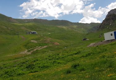
On a adoré cette randonnée.