![](/images/other/stat-length.png)
![Excursión Senderismo Carbis Bay - zennor - Photo](https://media.geolcdn.com/t/1900/400/ext.pjpeg?maxdim=2&url=https%3A%2F%2Fstatic1.geolcdn.com%2Fsiteimages%2Fupload%2Ffiles%2F1553511878bg_sport_marche.png)
zennor
cecile_ya
Usuario
![Longitud](/images/other/stat-length.png)
Longitud
11,7 km
![Altitud máxima](https://static1.geolcdn.com/siteimages/upload/files/1508320355ic_sort_altitude_max_24dp.png)
Altitud máxima
160 m
![Desnivel positivo](https://static1.geolcdn.com/siteimages/upload/files/1508320355ic_sort_den_pos_24dp.png)
Desnivel positivo
429 m
![Km-Effort](/images/other/stat-length.png)
Km-Effort
17 km
![Altitud mínima](https://static1.geolcdn.com/siteimages/upload/files/1508320355ic_sort_altitude_min_24dp.png)
Altitud mínima
8 m
![Desnivel negativo](https://static1.geolcdn.com/siteimages/upload/files/1508320355ic_sort_den_neg_24dp.png)
Desnivel negativo
296 m
![Boucle](https://static1.geolcdn.com/siteimages/upload/files/16400158638029165_repeat_loop_refresh_sync_direction_icon.png)
Boucle
No
Fecha de creación :
2019-06-23 09:16:54.466
Última modificación :
2019-06-23 15:38:03.745
![Senderismo](https://static1.geolcdn.com/sitytour/trail-icons/101.png)
5h28
Dificultad : Difícil
![Escanee este código QR para abrir la excursión en la aplicación SityTrail](https://capi.geolives.com/qq0zvz2zws4bq2lad0pu/sitytour/trails/2122014/qr.png?size=200)
Aplicación GPS de excursión GRATIS
A propósito
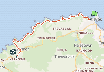
Ruta Senderismo de 11,7 km a descubrir en Inglaterra, Cornualles. Esta ruta ha sido propuesta por cecile_ya.
Descripción
splendide côte mais journée de pluie😣 la fin juin nous permet de voir les digitales et les bruyères, la mer est émeraude. le passage de rochers près de la plage avant Zennor point n'a de chemin que le nom.
Localización
País:
United Kingdom
Región :
Inglaterra
Departamento/provincia :
Cornualles
Municipio :
Carbis Bay
Localidad:
Unknown
Salida:(Dec)
Salida:(UTM)
322707 ; 5565413 (30U) N.
Comentarios
Excursiones cerca
![Excursión Senderismo - pendeen-drnnen cove + ale au old success Inn (stopwatch+30 Mon) - Photo](https://media.geolcdn.com/t/375/260/ext.jpg?maxdim=2&url=https%3A%2F%2Fstatic1.geolcdn.com%2Fsiteimages%2Fupload%2Ffiles%2F1553511878bg_sport_marche.png)
![Senderismo Senderismo](https://static1.geolcdn.com/sitytour/trail-icons/101.png)
pendeen-drnnen cove + ale au old success Inn (stopwatch+30 Mon)
Senderismo
Medio
,
Inglaterra,
Cornualles,
United Kingdom
![](/images/other/stat-length.png)
17,2 km | 23 km-effort
7h 2min
![](https://static1.geolcdn.com/siteimages/upload/files/16400158638029165_repeat_loop_refresh_sync_direction_icon.png)
No
![Excursión Senderismo - penzance à St Michaël mounts et retour - Photo](https://media.geolcdn.com/t/375/260/ext.jpg?maxdim=2&url=https%3A%2F%2Fstatic1.geolcdn.com%2Fsiteimages%2Fupload%2Ffiles%2F1553511878bg_sport_marche.png)
![Senderismo Senderismo](https://static1.geolcdn.com/sitytour/trail-icons/101.png)
penzance à St Michaël mounts et retour
Senderismo
Muy fácil
,
Inglaterra,
Cornualles,
United Kingdom
![](/images/other/stat-length.png)
13,9 km | 15 km-effort
3h 41min
![](https://static1.geolcdn.com/siteimages/upload/files/16400158638029165_repeat_loop_refresh_sync_direction_icon.png)
Sí
![Excursión Senderismo - Cornouaille Ouest - Photo](https://media.geolcdn.com/t/375/260/ext.jpg?maxdim=2&url=https%3A%2F%2Fstatic1.geolcdn.com%2Fsiteimages%2Fupload%2Ffiles%2F1553511878bg_sport_marche.png)
![Senderismo Senderismo](https://static1.geolcdn.com/sitytour/trail-icons/101.png)
Cornouaille Ouest
Senderismo
Fácil
,
Inglaterra,
Cornualles,
United Kingdom
![](/images/other/stat-length.png)
14,8 km | 18,8 km-effort
4h 15min
![](https://static1.geolcdn.com/siteimages/upload/files/16400158638029165_repeat_loop_refresh_sync_direction_icon.png)
Sí
![Excursión Senderismo - sortie du 13septembre - Photo](https://media.geolcdn.com/t/375/260/ext.jpg?maxdim=2&url=https%3A%2F%2Fstatic1.geolcdn.com%2Fsiteimages%2Fupload%2Ffiles%2F1553511878bg_sport_marche.png)
![Senderismo Senderismo](https://static1.geolcdn.com/sitytour/trail-icons/101.png)
sortie du 13septembre
Senderismo
Muy fácil
,
Inglaterra,
Cornualles,
United Kingdom
![](/images/other/stat-length.png)
7,2 km | 10,1 km-effort
4h 59min
![](https://static1.geolcdn.com/siteimages/upload/files/16400158638029165_repeat_loop_refresh_sync_direction_icon.png)
Sí
![Excursión Senderismo - sortie du 10 septembre - Photo](https://media.geolcdn.com/t/375/260/ext.jpg?maxdim=2&url=https%3A%2F%2Fstatic1.geolcdn.com%2Fsiteimages%2Fupload%2Ffiles%2F1553511878bg_sport_marche.png)
![Senderismo Senderismo](https://static1.geolcdn.com/sitytour/trail-icons/101.png)
sortie du 10 septembre
Senderismo
Muy fácil
,
Inglaterra,
Cornualles,
United Kingdom
![](/images/other/stat-length.png)
7,9 km | 10,5 km-effort
5h 14min
![](https://static1.geolcdn.com/siteimages/upload/files/16400158638029165_repeat_loop_refresh_sync_direction_icon.png)
Sí
![Excursión Senderismo - marche du 08 septembre 20a9 - Photo](https://media.geolcdn.com/t/375/260/ext.jpg?maxdim=2&url=https%3A%2F%2Fstatic1.geolcdn.com%2Fsiteimages%2Fupload%2Ffiles%2F1553511878bg_sport_marche.png)
![Senderismo Senderismo](https://static1.geolcdn.com/sitytour/trail-icons/101.png)
marche du 08 septembre 20a9
Senderismo
Muy fácil
,
Inglaterra,
Cornualles,
United Kingdom
![](/images/other/stat-length.png)
7,7 km | 10,1 km-effort
4h 30min
![](https://static1.geolcdn.com/siteimages/upload/files/16400158638029165_repeat_loop_refresh_sync_direction_icon.png)
Sí
![Excursión Senderismo - St-Just - Cape Cornwall - Photo](https://media.geolcdn.com/t/375/260/ext.jpg?maxdim=2&url=https%3A%2F%2Fstatic1.geolcdn.com%2Fsiteimages%2Fupload%2Ffiles%2F1553511878bg_sport_marche.png)
![Senderismo Senderismo](https://static1.geolcdn.com/sitytour/trail-icons/101.png)
St-Just - Cape Cornwall
Senderismo
Medio
,
Inglaterra,
Cornualles,
United Kingdom
![](/images/other/stat-length.png)
8,1 km | 10,8 km-effort
2h 17min
![](https://static1.geolcdn.com/siteimages/upload/files/16400158638029165_repeat_loop_refresh_sync_direction_icon.png)
Sí