![](/images/other/stat-length.png)
![Excursión Senderismo Lyons-la-Forêt - Lyons la Forêt - FR23 - Photo](https://media.geolcdn.com/t/1900/400/ext.pjpeg?maxdim=2&url=https%3A%2F%2Fstatic1.geolcdn.com%2Fsiteimages%2Fupload%2Ffiles%2F1553511878bg_sport_marche.png)
Lyons la Forêt - FR23
marcel.F
Usuario
![Longitud](/images/other/stat-length.png)
Longitud
23 km
![Altitud máxima](https://static1.geolcdn.com/siteimages/upload/files/1508320355ic_sort_altitude_max_24dp.png)
Altitud máxima
186 m
![Desnivel positivo](https://static1.geolcdn.com/siteimages/upload/files/1508320355ic_sort_den_pos_24dp.png)
Desnivel positivo
449 m
![Km-Effort](/images/other/stat-length.png)
Km-Effort
29 km
![Altitud mínima](https://static1.geolcdn.com/siteimages/upload/files/1508320355ic_sort_altitude_min_24dp.png)
Altitud mínima
35 m
![Desnivel negativo](https://static1.geolcdn.com/siteimages/upload/files/1508320355ic_sort_den_neg_24dp.png)
Desnivel negativo
448 m
![Boucle](https://static1.geolcdn.com/siteimages/upload/files/16400158638029165_repeat_loop_refresh_sync_direction_icon.png)
Boucle
Sí
Fecha de creación :
2019-06-22 14:05:28.891
Última modificación :
2019-06-24 18:43:23.342
![Senderismo](https://static1.geolcdn.com/sitytour/trail-icons/101.png)
12h00
Dificultad : Difícil
![Escanee este código QR para abrir la excursión en la aplicación SityTrail](https://capi.geolives.com/qq0zvz2zws4bq2lad0pu/sitytour/trails/2120842/qr.png?size=200)
Aplicación GPS de excursión GRATIS
A propósito
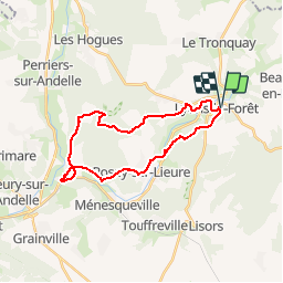
Ruta Senderismo de 23 km a descubrir en Normandía, Eure, Lyons-la-Forêt. Esta ruta ha sido propuesta por marcel.F.
Descripción
Fête de la randonnée à Lyons la Forêt le 15 septemmbre 2019
Marche longue avec pique-nique tiré du sac
Départ parking de la poste
Localización
País:
France
Región :
Normandía
Departamento/provincia :
Eure
Municipio :
Lyons-la-Forêt
Localidad:
Unknown
Salida:(Dec)
Salida:(UTM)
389658 ; 5472959 (31U) N.
Comentarios
Excursiones cerca
![Excursión Senderismo Lyons-la-Forêt - Sentier de la Fontaineresse - Lyons la Forêt - Photo](https://media.geolcdn.com/t/375/260/ext.jpg?maxdim=2&url=https%3A%2F%2Fservices.sitytrail.com%2FGeolivesWS%2FDownloadMedia.ashx%3FTrailID%3D191376%26Media%3D14945_6.jpg)
![Senderismo Senderismo](https://static1.geolcdn.com/sitytour/trail-icons/101.png)
Sentier de la Fontaineresse - Lyons la Forêt
Senderismo
Fácil
(1)
Lyons-la-Forêt,
Normandía,
Eure,
France
![](/images/other/stat-length.png)
6,3 km | 8,1 km-effort
2h 0min
![](https://static1.geolcdn.com/siteimages/upload/files/16400158638029165_repeat_loop_refresh_sync_direction_icon.png)
Sí
![Excursión Marcha nórdica Beauficel-en-Lyons - Marche Nordique 85 - Carrefour d'Auteil - Forêt de Lyons - Photo](https://media.geolcdn.com/t/375/260/ext.jpg?maxdim=2&url=https%3A%2F%2Fstatic1.geolcdn.com%2Fsiteimages%2Fupload%2Ffiles%2F1545311037marcheuse_200dpi.jpg)
![Marcha nórdica Marcha nórdica](https://static1.geolcdn.com/sitytour/trail-icons/102.png)
Marche Nordique 85 - Carrefour d'Auteil - Forêt de Lyons
Marcha nórdica
Fácil
(1)
Beauficel-en-Lyons,
Normandía,
Eure,
France
![](/images/other/stat-length.png)
9,5 km | 11,6 km-effort
1h 30min
![](https://static1.geolcdn.com/siteimages/upload/files/16400158638029165_repeat_loop_refresh_sync_direction_icon.png)
Sí
![Excursión Senderismo Lyons-la-Forêt - Lyons la Forêt - Le Val Bagnard 12 - Photo](https://media.geolcdn.com/t/375/260/ext.jpg?maxdim=2&url=https%3A%2F%2Fstatic1.geolcdn.com%2Fsiteimages%2Fupload%2Ffiles%2F1553511878bg_sport_marche.png)
![Senderismo Senderismo](https://static1.geolcdn.com/sitytour/trail-icons/101.png)
Lyons la Forêt - Le Val Bagnard 12
Senderismo
Medio
(1)
Lyons-la-Forêt,
Normandía,
Eure,
France
![](/images/other/stat-length.png)
12,2 km | 15,1 km-effort
2h 35min
![](https://static1.geolcdn.com/siteimages/upload/files/16400158638029165_repeat_loop_refresh_sync_direction_icon.png)
Sí
![Excursión Marcha nórdica Lyons-la-Forêt - MN 66 L'Essart Mador - Photo](https://media.geolcdn.com/t/375/260/ext.jpg?maxdim=2&url=https%3A%2F%2Fstatic1.geolcdn.com%2Fsiteimages%2Fupload%2Ffiles%2F1545311037marcheuse_200dpi.jpg)
![Marcha nórdica Marcha nórdica](https://static1.geolcdn.com/sitytour/trail-icons/102.png)
MN 66 L'Essart Mador
Marcha nórdica
Fácil
(2)
Lyons-la-Forêt,
Normandía,
Eure,
France
![](/images/other/stat-length.png)
8,9 km | 10,8 km-effort
1h 30min
![](https://static1.geolcdn.com/siteimages/upload/files/16400158638029165_repeat_loop_refresh_sync_direction_icon.png)
Sí
![Excursión Marcha nórdica Lyons-la-Forêt - Marche Nordique 37 Lyons la Forêt - Photo](https://media.geolcdn.com/t/375/260/ext.jpg?maxdim=2&url=https%3A%2F%2Fstatic1.geolcdn.com%2Fsiteimages%2Fupload%2Ffiles%2F1545311037marcheuse_200dpi.jpg)
![Marcha nórdica Marcha nórdica](https://static1.geolcdn.com/sitytour/trail-icons/102.png)
Marche Nordique 37 Lyons la Forêt
Marcha nórdica
Fácil
(2)
Lyons-la-Forêt,
Normandía,
Eure,
France
![](/images/other/stat-length.png)
7,8 km | 9,8 km-effort
1h 30min
![](https://static1.geolcdn.com/siteimages/upload/files/16400158638029165_repeat_loop_refresh_sync_direction_icon.png)
Sí
![Excursión Marcha nórdica Lyons-la-Forêt - Marche Nordique 65 - Forêt de lyons - Photo](https://media.geolcdn.com/t/375/260/ext.jpg?maxdim=2&url=https%3A%2F%2Fstatic1.geolcdn.com%2Fsiteimages%2Fupload%2Ffiles%2F1545311037marcheuse_200dpi.jpg)
![Marcha nórdica Marcha nórdica](https://static1.geolcdn.com/sitytour/trail-icons/102.png)
Marche Nordique 65 - Forêt de lyons
Marcha nórdica
Fácil
(1)
Lyons-la-Forêt,
Normandía,
Eure,
France
![](/images/other/stat-length.png)
8,6 km | 9,9 km-effort
Desconocido
![](https://static1.geolcdn.com/siteimages/upload/files/16400158638029165_repeat_loop_refresh_sync_direction_icon.png)
Sí
![Excursión Marcha nórdica Rosay-sur-Lieure - Marche Nordique 59 Rosay sur Lieure - Photo](https://media.geolcdn.com/t/375/260/ext.jpg?maxdim=2&url=https%3A%2F%2Fstatic1.geolcdn.com%2Fsiteimages%2Fupload%2Ffiles%2F1545311037marcheuse_200dpi.jpg)
![Marcha nórdica Marcha nórdica](https://static1.geolcdn.com/sitytour/trail-icons/102.png)
Marche Nordique 59 Rosay sur Lieure
Marcha nórdica
Medio
(1)
Rosay-sur-Lieure,
Normandía,
Eure,
France
![](/images/other/stat-length.png)
9,2 km | 10,9 km-effort
1h 30min
![](https://static1.geolcdn.com/siteimages/upload/files/16400158638029165_repeat_loop_refresh_sync_direction_icon.png)
Sí
![Excursión Senderismo Rosay-sur-Lieure - Rando Douce 1 - Rosay sur Lieure - Photo](https://media.geolcdn.com/t/375/260/ext.jpg?maxdim=2&url=https%3A%2F%2Fstatic1.geolcdn.com%2Fsiteimages%2Fupload%2Ffiles%2F1553511878bg_sport_marche.png)
![Senderismo Senderismo](https://static1.geolcdn.com/sitytour/trail-icons/101.png)
Rando Douce 1 - Rosay sur Lieure
Senderismo
Medio
(1)
Rosay-sur-Lieure,
Normandía,
Eure,
France
![](/images/other/stat-length.png)
6,2 km | 7,6 km-effort
2h 0min
![](https://static1.geolcdn.com/siteimages/upload/files/16400158638029165_repeat_loop_refresh_sync_direction_icon.png)
Sí
![Excursión Senderismo Rosay-sur-Lieure - Rosay-sur-Lieure - vers Charleval - Photo](https://media.geolcdn.com/t/375/260/ext.jpg?maxdim=2&url=https%3A%2F%2Fstatic1.geolcdn.com%2Fsiteimages%2Fupload%2Ffiles%2F1553511878bg_sport_marche.png)
![Senderismo Senderismo](https://static1.geolcdn.com/sitytour/trail-icons/101.png)
Rosay-sur-Lieure - vers Charleval
Senderismo
Fácil
(1)
Rosay-sur-Lieure,
Normandía,
Eure,
France
![](/images/other/stat-length.png)
9,4 km | 11,6 km-effort
3h 1min
![](https://static1.geolcdn.com/siteimages/upload/files/16400158638029165_repeat_loop_refresh_sync_direction_icon.png)
Sí