![](/images/other/stat-length.png)
Breitsouze
oscar1
Usuario
![Longitud](/images/other/stat-length.png)
Longitud
17,2 km
![Altitud máxima](https://static1.geolcdn.com/siteimages/upload/files/1508320355ic_sort_altitude_max_24dp.png)
Altitud máxima
1304 m
![Desnivel positivo](https://static1.geolcdn.com/siteimages/upload/files/1508320355ic_sort_den_pos_24dp.png)
Desnivel positivo
718 m
![Km-Effort](/images/other/stat-length.png)
Km-Effort
27 km
![Altitud mínima](https://static1.geolcdn.com/siteimages/upload/files/1508320355ic_sort_altitude_min_24dp.png)
Altitud mínima
965 m
![Desnivel negativo](https://static1.geolcdn.com/siteimages/upload/files/1508320355ic_sort_den_neg_24dp.png)
Desnivel negativo
726 m
![Boucle](https://static1.geolcdn.com/siteimages/upload/files/16400158638029165_repeat_loop_refresh_sync_direction_icon.png)
Boucle
No
Fecha de creación :
2019-06-13 07:43:46.084
Última modificación :
2019-06-14 14:11:08.642
![Senderismo](https://static1.geolcdn.com/sitytour/trail-icons/101.png)
5h03
Dificultad : Muy fácil
![Escanee este código QR para abrir la excursión en la aplicación SityTrail](https://capi.geolives.com/qq0zvz2zws4bq2lad0pu/sitytour/trails/2112740/qr.png?size=200)
Aplicación GPS de excursión GRATIS
A propósito
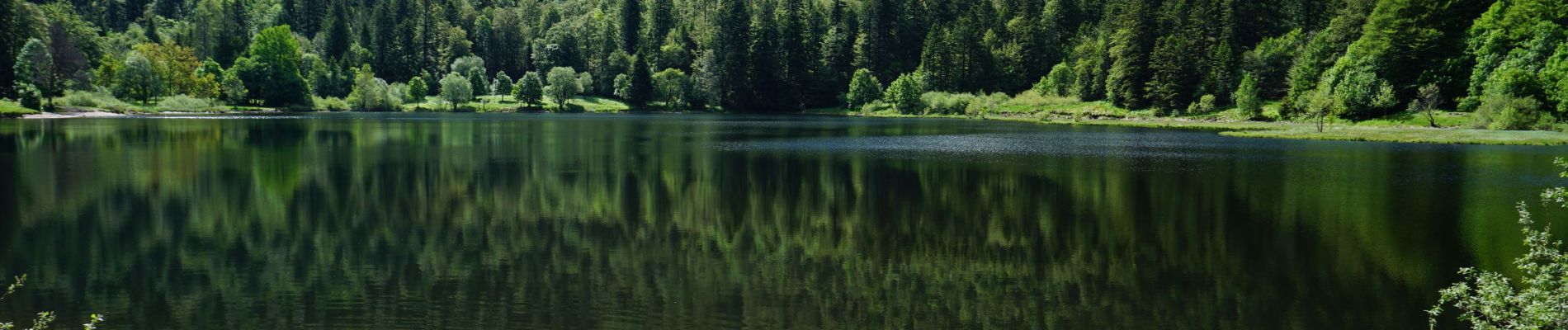
Ruta Senderismo de 17,2 km a descubrir en Gran Este, Vosgos, La Bresse. Esta ruta ha sido propuesta por oscar1.
Descripción
Départ ferme auberge Breitsouze. Lac de Blanchemer, la tourbière de Machais, le col de Bramont, Ronde Tête, la Source de la Thur, le Rainkopf.
Localización
País:
France
Región :
Gran Este
Departamento/provincia :
Vosgos
Municipio :
La Bresse
Localidad:
Unknown
Salida:(Dec)
Salida:(UTM)
350516 ; 5320967 (32U) N.
Comentarios
Excursiones cerca
![Excursión Senderismo La Bresse - 2023-04-16 Marche Abri Lac de Blanchemer vers Lac de Lispach - Photo](https://media.geolcdn.com/t/375/260/20b642e6-a3a8-4790-bc8e-b2ad298c0408.jpg&format=jpg&maxdim=2)
![Senderismo Senderismo](https://static1.geolcdn.com/sitytour/trail-icons/101.png)
2023-04-16 Marche Abri Lac de Blanchemer vers Lac de Lispach
Senderismo
Muy difícil
(1)
La Bresse,
Gran Este,
Vosgos,
France
![](/images/other/stat-length.png)
23 km | 36 km-effort
8h 4min
![](https://static1.geolcdn.com/siteimages/upload/files/16400158638029165_repeat_loop_refresh_sync_direction_icon.png)
No
![Excursión Senderismo La Bresse - 2023-04-15 Marche Abri Collet de Etang vers Abri Lac de Blanchemer - Photo](https://media.geolcdn.com/t/375/260/f5705708-8e73-435e-a1e8-28d1d0c03215.jpg&format=jpg&maxdim=2)
![Senderismo Senderismo](https://static1.geolcdn.com/sitytour/trail-icons/101.png)
2023-04-15 Marche Abri Collet de Etang vers Abri Lac de Blanchemer
Senderismo
Medio
(1)
La Bresse,
Gran Este,
Vosgos,
France
![](/images/other/stat-length.png)
22 km | 35 km-effort
7h 51min
![](https://static1.geolcdn.com/siteimages/upload/files/16400158638029165_repeat_loop_refresh_sync_direction_icon.png)
No
![Excursión Senderismo Wildenstein - 2022-02-20 Marche Kruth Grand Ventron - Photo](https://media.geolcdn.com/t/375/260/74324e84-ba09-479c-87ba-50417488039d.jpg&format=jpg&maxdim=2)
![Senderismo Senderismo](https://static1.geolcdn.com/sitytour/trail-icons/101.png)
2022-02-20 Marche Kruth Grand Ventron
Senderismo
Muy difícil
(1)
Wildenstein,
Gran Este,
Alto Rin,
France
![](/images/other/stat-length.png)
16,8 km | 27 km-effort
4h 52min
![](https://static1.geolcdn.com/siteimages/upload/files/16400158638029165_repeat_loop_refresh_sync_direction_icon.png)
Sí
![Excursión Senderismo Le Valtin - Les Rochers des Hirschsteine - Lac Vert - Photo](https://media.geolcdn.com/t/375/260/4177d9e5-d8bc-4dac-ac45-c42f01ca30d3.jpg&format=jpg&maxdim=2)
![Senderismo Senderismo](https://static1.geolcdn.com/sitytour/trail-icons/101.png)
Les Rochers des Hirschsteine - Lac Vert
Senderismo
Difícil
(2)
Le Valtin,
Gran Este,
Vosgos,
France
![](/images/other/stat-length.png)
14,4 km | 22 km-effort
5h 2min
![](https://static1.geolcdn.com/siteimages/upload/files/16400158638029165_repeat_loop_refresh_sync_direction_icon.png)
Sí
![Excursión Senderismo La Bresse - Kastelberg des pierres, des lacs, des panoramas magnifiques - Photo](https://media.geolcdn.com/t/375/260/cada329c-fae7-4d3f-815e-38ed5d6ce361.jpg&format=jpg&maxdim=2)
![Senderismo Senderismo](https://static1.geolcdn.com/sitytour/trail-icons/101.png)
Kastelberg des pierres, des lacs, des panoramas magnifiques
Senderismo
Difícil
(1)
La Bresse,
Gran Este,
Vosgos,
France
![](/images/other/stat-length.png)
15,1 km | 26 km-effort
6h 11min
![](https://static1.geolcdn.com/siteimages/upload/files/16400158638029165_repeat_loop_refresh_sync_direction_icon.png)
Sí
![Excursión Senderismo Le Valtin - Col de la Schlucht - Photo](https://media.geolcdn.com/t/375/260/5b598871-c43c-4378-92fe-f06bddb4af29.jpg&format=jpg&maxdim=2)
![Senderismo Senderismo](https://static1.geolcdn.com/sitytour/trail-icons/101.png)
Col de la Schlucht
Senderismo
Muy fácil
(1)
Le Valtin,
Gran Este,
Vosgos,
France
![](/images/other/stat-length.png)
3,5 km | 5,2 km-effort
1h 17min
![](https://static1.geolcdn.com/siteimages/upload/files/16400158638029165_repeat_loop_refresh_sync_direction_icon.png)
Sí
![Excursión Senderismo Wildenstein - TREK ALSACIEN (boucle de Wildenstein) - Photo](https://media.geolcdn.com/t/375/260/319755c6-b355-43a3-9980-ff414aa67ddf.jpg&format=jpg&maxdim=2)
![Senderismo Senderismo](https://static1.geolcdn.com/sitytour/trail-icons/101.png)
TREK ALSACIEN (boucle de Wildenstein)
Senderismo
Difícil
(1)
Wildenstein,
Gran Este,
Alto Rin,
France
![](/images/other/stat-length.png)
15,4 km | 24 km-effort
5h 20min
![](https://static1.geolcdn.com/siteimages/upload/files/16400158638029165_repeat_loop_refresh_sync_direction_icon.png)
Sí
![Excursión Senderismo Le Valtin - Le Sentier des Roches - Photo](https://media.geolcdn.com/t/375/260/f2737479-0e9e-43ec-9b66-c9706dc8ef91.jpg&format=jpg&maxdim=2)
![Senderismo Senderismo](https://static1.geolcdn.com/sitytour/trail-icons/101.png)
Le Sentier des Roches
Senderismo
Difícil
(2)
Le Valtin,
Gran Este,
Vosgos,
France
![](/images/other/stat-length.png)
20 km | 34 km-effort
7h 43min
![](https://static1.geolcdn.com/siteimages/upload/files/16400158638029165_repeat_loop_refresh_sync_direction_icon.png)
Sí
![Excursión Senderismo La Bresse - Lac de Lispach et sentier Dielaine - Photo](https://media.geolcdn.com/t/375/260/b54731ea-6209-4cff-b7c0-af5225a4f3ae.jpg&format=jpg&maxdim=2)
![Senderismo Senderismo](https://static1.geolcdn.com/sitytour/trail-icons/101.png)
Lac de Lispach et sentier Dielaine
Senderismo
Medio
(1)
La Bresse,
Gran Este,
Vosgos,
France
![](/images/other/stat-length.png)
9,7 km | 14,9 km-effort
2h 30min
![](https://static1.geolcdn.com/siteimages/upload/files/16400158638029165_repeat_loop_refresh_sync_direction_icon.png)
Sí