![](/images/other/stat-length.png)
![Excursión Senderismo Sion-les-Mines - Boucle 16 km à Saint Aubin des Chateaux - Photo](https://media.geolcdn.com/t/1900/400/b59baf9c-b9dc-4059-aa9d-3e434dd3b598.jpg&format=pjpeg&maxdim=2)
Boucle 16 km à Saint Aubin des Chateaux
vincent35
Usuario
![Longitud](/images/other/stat-length.png)
Longitud
16,3 km
![Altitud máxima](https://static1.geolcdn.com/siteimages/upload/files/1508320355ic_sort_altitude_max_24dp.png)
Altitud máxima
86 m
![Desnivel positivo](https://static1.geolcdn.com/siteimages/upload/files/1508320355ic_sort_den_pos_24dp.png)
Desnivel positivo
171 m
![Km-Effort](/images/other/stat-length.png)
Km-Effort
18,6 km
![Altitud mínima](https://static1.geolcdn.com/siteimages/upload/files/1508320355ic_sort_altitude_min_24dp.png)
Altitud mínima
31 m
![Desnivel negativo](https://static1.geolcdn.com/siteimages/upload/files/1508320355ic_sort_den_neg_24dp.png)
Desnivel negativo
173 m
![Boucle](https://static1.geolcdn.com/siteimages/upload/files/16400158638029165_repeat_loop_refresh_sync_direction_icon.png)
Boucle
Sí
Fecha de creación :
2019-05-22 07:37:43.066
Última modificación :
2019-06-12 08:57:56.975
![Senderismo](https://static1.geolcdn.com/sitytour/trail-icons/101.png)
4h18
Dificultad : Muy fácil
![Escanee este código QR para abrir la excursión en la aplicación SityTrail](https://capi.geolives.com/qq0zvz2zws4bq2lad0pu/sitytour/trails/2091262/qr.png?size=200)
Aplicación GPS de excursión GRATIS
A propósito
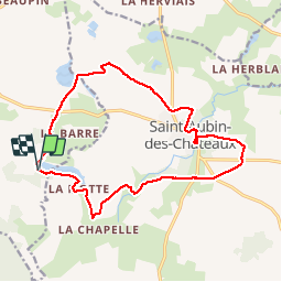
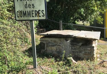
Ruta Senderismo de 16,3 km a descubrir en Países del Loira, Loira-Atlántico, Sion-les-Mines. Esta ruta ha sido propuesta por vincent35.
Descripción
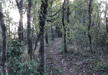
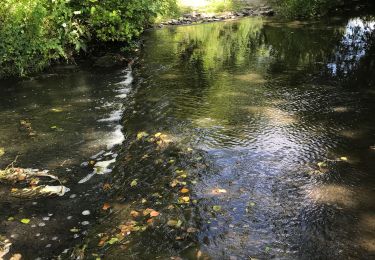
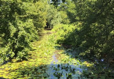
Sentiers et chemins ruraux très bien balisés.
Pas de fifficultés particulières.
Tres belles allées ombragées
A St Aubin des Chateaux voir :
La chapelle des Templiers, Le Château du Plessis, Le menhir des Loueres
Localización
País:
France
Región :
Países del Loira
Departamento/provincia :
Loira-Atlántico
Municipio :
Sion-les-Mines
Localidad:
Unknown
Salida:(Dec)
Salida:(UTM)
610104 ; 5285349 (30T) N.
Comentarios
Excursiones cerca
![Excursión A pie Sion-les-Mines - Tour de l'étang de la Hunaudière - Photo](https://media.geolcdn.com/t/375/260/d36b3415-773b-457b-8444-4f8abcd71db7.jpeg&format=jpg&maxdim=2)
![A pie A pie](https://static1.geolcdn.com/sitytour/trail-icons/100.png)
Tour de l'étang de la Hunaudière
A pie
Fácil
Sion-les-Mines,
Países del Loira,
Loira-Atlántico,
France
![](/images/other/stat-length.png)
5,9 km | 6,5 km-effort
1h 28min
![](https://static1.geolcdn.com/siteimages/upload/files/16400158638029165_repeat_loop_refresh_sync_direction_icon.png)
Sí
![Excursión Senderismo Sion-les-Mines - La Hunaudière - Photo](https://media.geolcdn.com/t/375/260/ext.jpg?maxdim=2&url=https%3A%2F%2Fservices.sitytrail.com%2FGeolivesWS%2FDownloadMedia.ashx%3FTrailID%3D101747%26Media%3D1996_4.jpg)
![Senderismo Senderismo](https://static1.geolcdn.com/sitytour/trail-icons/101.png)
La Hunaudière
Senderismo
Medio
Sion-les-Mines,
Países del Loira,
Loira-Atlántico,
France
![](/images/other/stat-length.png)
11,4 km | 12,9 km-effort
2h 30min
![](https://static1.geolcdn.com/siteimages/upload/files/16400158638029165_repeat_loop_refresh_sync_direction_icon.png)
Sí
![Excursión Senderismo Sion-les-Mines - Etang de La Hunaudière - Photo](https://media.geolcdn.com/t/375/260/ext.jpg?maxdim=2&url=https%3A%2F%2Fstatic1.geolcdn.com%2Fsiteimages%2Fupload%2Ffiles%2F1553511878bg_sport_marche.png)
![Senderismo Senderismo](https://static1.geolcdn.com/sitytour/trail-icons/101.png)
Etang de La Hunaudière
Senderismo
Fácil
Sion-les-Mines,
Países del Loira,
Loira-Atlántico,
France
![](/images/other/stat-length.png)
22 km | 24 km-effort
1h 48min
![](https://static1.geolcdn.com/siteimages/upload/files/16400158638029165_repeat_loop_refresh_sync_direction_icon.png)
No
![Excursión Senderismo Saint-Aubin-des-Châteaux - Etangs et calvaire de St Aubin des Chateaux 13km - Photo](https://media.geolcdn.com/t/375/260/ext.jpg?maxdim=2&url=https%3A%2F%2Fstatic1.geolcdn.com%2Fsiteimages%2Fupload%2Ffiles%2F1553511878bg_sport_marche.png)
![Senderismo Senderismo](https://static1.geolcdn.com/sitytour/trail-icons/101.png)
Etangs et calvaire de St Aubin des Chateaux 13km
Senderismo
Difícil
(1)
Saint-Aubin-des-Châteaux,
Países del Loira,
Loira-Atlántico,
France
![](/images/other/stat-length.png)
12,7 km | 14,5 km-effort
3h 21min
![](https://static1.geolcdn.com/siteimages/upload/files/16400158638029165_repeat_loop_refresh_sync_direction_icon.png)
Sí
![Excursión Senderismo Sion-les-Mines - 08.09.2019 - SION LES MINES - Photo](https://media.geolcdn.com/t/375/260/8b9cd7bd-86e1-4f2f-83a8-23f1780eb138.jpg&format=jpg&maxdim=2)
![Senderismo Senderismo](https://static1.geolcdn.com/sitytour/trail-icons/101.png)
08.09.2019 - SION LES MINES
Senderismo
Medio
Sion-les-Mines,
Países del Loira,
Loira-Atlántico,
France
![](/images/other/stat-length.png)
28 km | 30 km-effort
5h 52min
![](https://static1.geolcdn.com/siteimages/upload/files/16400158638029165_repeat_loop_refresh_sync_direction_icon.png)
Sí
![Excursión Senderismo Sion-les-Mines - 08.09.2019 - SION LES MINES - Photo](https://media.geolcdn.com/t/375/260/e46cb871-a039-4ac4-8cc7-aa7b29cfbded.jpg&format=jpg&maxdim=2)
![Senderismo Senderismo](https://static1.geolcdn.com/sitytour/trail-icons/101.png)
08.09.2019 - SION LES MINES
Senderismo
Medio
Sion-les-Mines,
Países del Loira,
Loira-Atlántico,
France
![](/images/other/stat-length.png)
28 km | 30 km-effort
5h 52min
![](https://static1.geolcdn.com/siteimages/upload/files/16400158638029165_repeat_loop_refresh_sync_direction_icon.png)
Sí
![Excursión Senderismo Ruffigné - 15.07.2019 - RUFFIGNE à ST AUBIN DES CHÂTEAUX sud - Photo](https://media.geolcdn.com/t/375/260/de7ae6be-3d32-4131-9e97-c2ec4ea6ce0d.jpg&format=jpg&maxdim=2)
![Senderismo Senderismo](https://static1.geolcdn.com/sitytour/trail-icons/101.png)
15.07.2019 - RUFFIGNE à ST AUBIN DES CHÂTEAUX sud
Senderismo
Difícil
Ruffigné,
Países del Loira,
Loira-Atlántico,
France
![](/images/other/stat-length.png)
28 km | 32 km-effort
7h 17min
![](https://static1.geolcdn.com/siteimages/upload/files/16400158638029165_repeat_loop_refresh_sync_direction_icon.png)
Sí
![Excursión Senderismo Sion-les-Mines - 09.07.2019 - de SION les MINES à ST AUBIN DES CHÂTEAUX - Photo](https://media.geolcdn.com/t/375/260/225337f8-649e-45e9-a578-31f14ca2aaf6.jpg&format=jpg&maxdim=2)
![Senderismo Senderismo](https://static1.geolcdn.com/sitytour/trail-icons/101.png)
09.07.2019 - de SION les MINES à ST AUBIN DES CHÂTEAUX
Senderismo
Difícil
Sion-les-Mines,
Países del Loira,
Loira-Atlántico,
France
![](/images/other/stat-length.png)
30 km | 0 m-effort
6h 52min
![](https://static1.geolcdn.com/siteimages/upload/files/16400158638029165_repeat_loop_refresh_sync_direction_icon.png)
Sí
![Excursión Senderismo Sion-les-Mines - SION LES MINES - Photo](https://media.geolcdn.com/t/375/260/ext.jpg?maxdim=2&url=https%3A%2F%2Fstatic1.geolcdn.com%2Fsiteimages%2Fupload%2Ffiles%2F1553511878bg_sport_marche.png)
![Senderismo Senderismo](https://static1.geolcdn.com/sitytour/trail-icons/101.png)
SION LES MINES
Senderismo
Muy fácil
Sion-les-Mines,
Países del Loira,
Loira-Atlántico,
France
![](/images/other/stat-length.png)
15,1 km | 17,1 km-effort
3h 59min
![](https://static1.geolcdn.com/siteimages/upload/files/16400158638029165_repeat_loop_refresh_sync_direction_icon.png)
Sí