![](/images/other/stat-length.png)
![Excursión Senderismo Saint-Martin-de-Valamas - Saint-Martin-de-Valamas . De pierres et d'or - Photo](https://media.geolcdn.com/t/1900/400/ext.pjpeg?maxdim=2&url=https%3A%2F%2Fmedia.geolcdn.com%2Ff%2F46d2a52a-8f9f-4ab9-bbef-28c7756eb625.jpg)
Saint-Martin-de-Valamas . De pierres et d'or
bernadette revoux
Usuario
![Longitud](/images/other/stat-length.png)
Longitud
24 km
![Altitud máxima](https://static1.geolcdn.com/siteimages/upload/files/1508320355ic_sort_altitude_max_24dp.png)
Altitud máxima
904 m
![Desnivel positivo](https://static1.geolcdn.com/siteimages/upload/files/1508320355ic_sort_den_pos_24dp.png)
Desnivel positivo
1179 m
![Km-Effort](/images/other/stat-length.png)
Km-Effort
39 km
![Altitud mínima](https://static1.geolcdn.com/siteimages/upload/files/1508320355ic_sort_altitude_min_24dp.png)
Altitud mínima
493 m
![Desnivel negativo](https://static1.geolcdn.com/siteimages/upload/files/1508320355ic_sort_den_neg_24dp.png)
Desnivel negativo
1176 m
![Boucle](https://static1.geolcdn.com/siteimages/upload/files/16400158638029165_repeat_loop_refresh_sync_direction_icon.png)
Boucle
Sí
Fecha de creación :
2019-05-18 06:09:36.186
Última modificación :
2019-05-20 18:37:34.503
![Senderismo](https://static1.geolcdn.com/sitytour/trail-icons/101.png)
6h53
Dificultad : Difícil
![Escanee este código QR para abrir la excursión en la aplicación SityTrail](https://capi.geolives.com/qq0zvz2zws4bq2lad0pu/sitytour/trails/2087101/qr.png?size=200)
Aplicación GPS de excursión GRATIS
A propósito
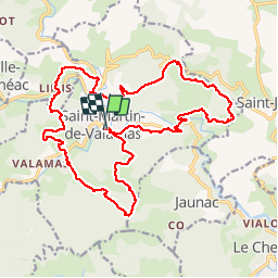
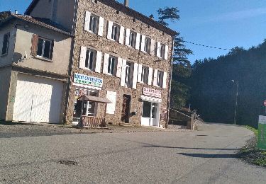
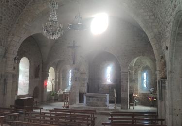
Ruta Senderismo de 24 km a descubrir en Auvergne-Rhône-Alpes, Ardecha, Saint-Martin-de-Valamas. Esta ruta ha sido propuesta por bernadette revoux.
Descripción
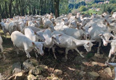
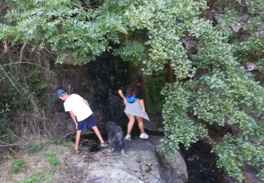
De pierres et d'or. Rando organisée par l'association "chemins oubliés des Boutières"
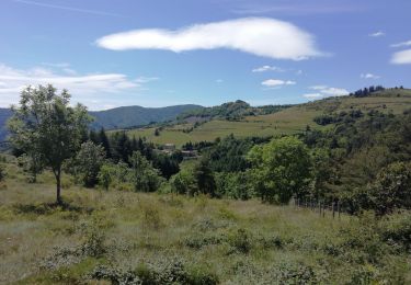
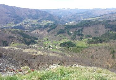
De plaines en forêt, de vallons en collines. La montagne est belle (Jean Ferrat)
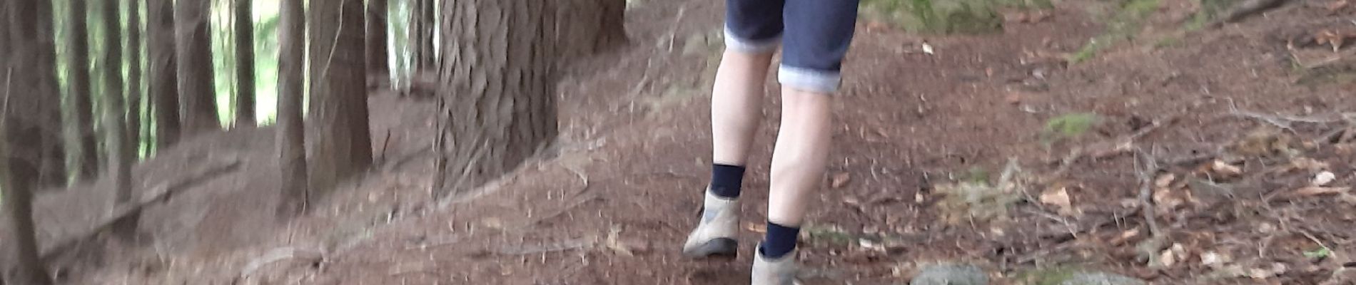
Localización
País:
France
Región :
Auvergne-Rhône-Alpes
Departamento/provincia :
Ardecha
Municipio :
Saint-Martin-de-Valamas
Localidad:
Unknown
Salida:(Dec)
Salida:(UTM)
608008 ; 4976710 (31T) N.
Comentarios
Excursiones cerca
![Excursión Senderismo Jaunac - Jaunac 10km - Photo](https://media.geolcdn.com/t/375/260/ext.jpg?maxdim=2&url=https%3A%2F%2Fmedia.geolcdn.com%2Ff%2F61afb06a-0ece-40c0-8969-cdeb0a9812fa.jpg)
![Senderismo Senderismo](https://static1.geolcdn.com/sitytour/trail-icons/101.png)
Jaunac 10km
Senderismo
Fácil
Jaunac,
Auvergne-Rhône-Alpes,
Ardecha,
France
![](/images/other/stat-length.png)
9,3 km | 14 km-effort
4h 38min
![](https://static1.geolcdn.com/siteimages/upload/files/16400158638029165_repeat_loop_refresh_sync_direction_icon.png)
Sí
![Excursión Senderismo Saint-Martin-de-Valamas - Le chemin du Brion - Photo](https://media.geolcdn.com/t/375/260/ext.jpg?maxdim=2&url=https%3A%2F%2Fstatic1.geolcdn.com%2Fsiteimages%2Fupload%2Ffiles%2F1553511878bg_sport_marche.png)
![Senderismo Senderismo](https://static1.geolcdn.com/sitytour/trail-icons/101.png)
Le chemin du Brion
Senderismo
Difícil
(1)
Saint-Martin-de-Valamas,
Auvergne-Rhône-Alpes,
Ardecha,
France
![](/images/other/stat-length.png)
11,8 km | 19,4 km-effort
3h 59min
![](https://static1.geolcdn.com/siteimages/upload/files/16400158638029165_repeat_loop_refresh_sync_direction_icon.png)
Sí
![Excursión Senderismo Le Cheylard - Randonnée Le cheylard - Saint-Agrève - Lac Devesset - Photo](https://media.geolcdn.com/t/375/260/ext.jpg?maxdim=2&url=https%3A%2F%2Fstatic1.geolcdn.com%2Fsiteimages%2Fupload%2Ffiles%2F1553511878bg_sport_marche.png)
![Senderismo Senderismo](https://static1.geolcdn.com/sitytour/trail-icons/101.png)
Randonnée Le cheylard - Saint-Agrève - Lac Devesset
Senderismo
Medio
(2)
Le Cheylard,
Auvergne-Rhône-Alpes,
Ardecha,
France
![](/images/other/stat-length.png)
34 km | 45 km-effort
9h 55min
![](https://static1.geolcdn.com/siteimages/upload/files/16400158638029165_repeat_loop_refresh_sync_direction_icon.png)
No
![Excursión Senderismo Le Cheylard - Le Cheylard -> Saint Martin de Valamas - Photo](https://media.geolcdn.com/t/375/260/ext.jpg?maxdim=2&url=https%3A%2F%2Fservices.sitytrail.com%2FGeolivesWS%2FDownloadMedia.ashx%3FTrailID%3D911165%26Media%3Dfix__20180123114120.jpg)
![Senderismo Senderismo](https://static1.geolcdn.com/sitytour/trail-icons/101.png)
Le Cheylard -> Saint Martin de Valamas
Senderismo
Muy fácil
Le Cheylard,
Auvergne-Rhône-Alpes,
Ardecha,
France
![](/images/other/stat-length.png)
17,4 km | 22 km-effort
5h 9min
![](https://static1.geolcdn.com/siteimages/upload/files/16400158638029165_repeat_loop_refresh_sync_direction_icon.png)
Sí
![Excursión Carrera Le Cheylard - la glorie rocher de brion - Photo](https://media.geolcdn.com/t/375/260/ext.jpg?maxdim=2&url=https%3A%2F%2Fservices.sitytrail.com%2FGeolivesWS%2FDownloadMedia.ashx%3FTrailID%3D184065%26Media%3D20130410110919.jpeg)
![Carrera Carrera](https://static1.geolcdn.com/sitytour/trail-icons/103.png)
la glorie rocher de brion
Carrera
Difícil
Le Cheylard,
Auvergne-Rhône-Alpes,
Ardecha,
France
![](/images/other/stat-length.png)
8 km | 12,6 km-effort
1h 7min
![](https://static1.geolcdn.com/siteimages/upload/files/16400158638029165_repeat_loop_refresh_sync_direction_icon.png)
Sí
![Excursión Senderismo Le Cheylard - Cheylard3 - Photo](https://media.geolcdn.com/t/375/260/ext.jpg?maxdim=2&url=https%3A%2F%2Fmedia.geolcdn.com%2Ff%2Ff3df96e6-1a4a-420e-a093-18172795c95e.jpg)
![Senderismo Senderismo](https://static1.geolcdn.com/sitytour/trail-icons/101.png)
Cheylard3
Senderismo
Difícil
Le Cheylard,
Auvergne-Rhône-Alpes,
Ardecha,
France
![](/images/other/stat-length.png)
9,1 km | 13,7 km-effort
2h 48min
![](https://static1.geolcdn.com/siteimages/upload/files/16400158638029165_repeat_loop_refresh_sync_direction_icon.png)
No
![Excursión Bici de carretera Saint-Martin-de-Valamas - st martin-de-valamas Saint-Agreve - Photo](https://media.geolcdn.com/t/375/260/ext.jpg?maxdim=2&url=https%3A%2F%2Fmedia.geolcdn.com%2Ff%2F66308dac-abe7-4632-be40-c1d63216b882.jpg)
![Bici de carretera Bici de carretera](https://static1.geolcdn.com/sitytour/trail-icons/201.png)
st martin-de-valamas Saint-Agreve
Bici de carretera
Difícil
Saint-Martin-de-Valamas,
Auvergne-Rhône-Alpes,
Ardecha,
France
![](/images/other/stat-length.png)
16,7 km | 24 km-effort
5h 2min
![](https://static1.geolcdn.com/siteimages/upload/files/16400158638029165_repeat_loop_refresh_sync_direction_icon.png)
No
![Excursión Senderismo Saint-Martin-de-Valamas - St Martin de Valamas Château de Rochebonne - Photo](https://media.geolcdn.com/t/375/260/ext.jpg?maxdim=2&url=https%3A%2F%2Fmedia.geolcdn.com%2Ff%2F7308affe-bc79-4b32-bb21-0dc1b6a77f10.jpg)
![Senderismo Senderismo](https://static1.geolcdn.com/sitytour/trail-icons/101.png)
St Martin de Valamas Château de Rochebonne
Senderismo
Difícil
Saint-Martin-de-Valamas,
Auvergne-Rhône-Alpes,
Ardecha,
France
![](/images/other/stat-length.png)
9,4 km | 15,8 km-effort
5h 29min
![](https://static1.geolcdn.com/siteimages/upload/files/16400158638029165_repeat_loop_refresh_sync_direction_icon.png)
Sí
![Excursión Senderismo Lachapelle-sous-Chanéac - la chapelle sous chaneac - le mezenc - Photo](https://media.geolcdn.com/t/375/260/ext.jpg?maxdim=2&url=https%3A%2F%2Fservices.sitytrail.com%2FGeolivesWS%2FDownloadMedia.ashx%3FTrailID%3D324201%26Media%3Dfix__20140714135359.jpg)
![Senderismo Senderismo](https://static1.geolcdn.com/sitytour/trail-icons/101.png)
la chapelle sous chaneac - le mezenc
Senderismo
Medio
Lachapelle-sous-Chanéac,
Auvergne-Rhône-Alpes,
Ardecha,
France
![](/images/other/stat-length.png)
24 km | 37 km-effort
8h 10min
![](https://static1.geolcdn.com/siteimages/upload/files/16400158638029165_repeat_loop_refresh_sync_direction_icon.png)
No