![](/images/other/stat-length.png)
![Excursión Bici de montaña Nans-les-Pins - De. St Sacharie vers la Ste Baume - Photo](https://media.geolcdn.com/t/1900/400/9b1b101f-d6a5-422d-b361-b44b868e3e6f.jpg&format=pjpeg&maxdim=2)
De. St Sacharie vers la Ste Baume
tophe73
Usuario
![Longitud](/images/other/stat-length.png)
Longitud
38 km
![Altitud máxima](https://static1.geolcdn.com/siteimages/upload/files/1508320355ic_sort_altitude_max_24dp.png)
Altitud máxima
741 m
![Desnivel positivo](https://static1.geolcdn.com/siteimages/upload/files/1508320355ic_sort_den_pos_24dp.png)
Desnivel positivo
1034 m
![Km-Effort](/images/other/stat-length.png)
Km-Effort
52 km
![Altitud mínima](https://static1.geolcdn.com/siteimages/upload/files/1508320355ic_sort_altitude_min_24dp.png)
Altitud mínima
275 m
![Desnivel negativo](https://static1.geolcdn.com/siteimages/upload/files/1508320355ic_sort_den_neg_24dp.png)
Desnivel negativo
1211 m
![Boucle](https://static1.geolcdn.com/siteimages/upload/files/16400158638029165_repeat_loop_refresh_sync_direction_icon.png)
Boucle
No
Fecha de creación :
2019-05-11 09:43:47.213
Última modificación :
2019-05-11 15:06:46.226
![Bici de montaña](https://static1.geolcdn.com/sitytour/trail-icons/202.png)
5h20
Dificultad : Muy difícil
![Escanee este código QR para abrir la excursión en la aplicación SityTrail](https://capi.geolives.com/qq0zvz2zws4bq2lad0pu/sitytour/trails/2079139/qr.png?size=200)
Aplicación GPS de excursión GRATIS
A propósito
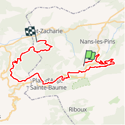
Ruta Bici de montaña de 38 km a descubrir en Provenza-Alpes-Costa Azul, Var, Nans-les-Pins. Esta ruta ha sido propuesta por tophe73.
Descripción
randonnée VTT très difficile car beaucoup de single technique autant à la montée qu'à la descente point sinon un parcours fabuleux
Localización
País:
France
Región :
Provenza-Alpes-Costa Azul
Departamento/provincia :
Var
Municipio :
Nans-les-Pins
Localidad:
Unknown
Salida:(Dec)
Salida:(UTM)
724023 ; 4803121 (31T) N.
Comentarios
Excursiones cerca
![Excursión Senderismo Plan-d'Aups-Sainte-Baume - Sainte Baume 8,5 km - Photo](https://media.geolcdn.com/t/375/260/02bfd54c-87ac-472a-9dd7-603e289d99c6.jpeg&format=jpg&maxdim=2)
![Senderismo Senderismo](https://static1.geolcdn.com/sitytour/trail-icons/101.png)
Sainte Baume 8,5 km
Senderismo
Medio
(1)
Plan-d'Aups-Sainte-Baume,
Provenza-Alpes-Costa Azul,
Var,
France
![](/images/other/stat-length.png)
8,4 km | 15,5 km-effort
4h 38min
![](https://static1.geolcdn.com/siteimages/upload/files/16400158638029165_repeat_loop_refresh_sync_direction_icon.png)
Sí
![Excursión Senderismo Nans-les-Pins - Le baou des glacières - Photo](https://media.geolcdn.com/t/375/260/ext.jpg?maxdim=2&url=https%3A%2F%2Fservices.sitytrail.com%2FGeolivesWS%2FDownloadMedia.ashx%3FTrailID%3D356935%26Media%3Dfix__20141025130409.jpg)
![Senderismo Senderismo](https://static1.geolcdn.com/sitytour/trail-icons/101.png)
Le baou des glacières
Senderismo
Medio
(1)
Nans-les-Pins,
Provenza-Alpes-Costa Azul,
Var,
France
![](/images/other/stat-length.png)
7,6 km | 12,2 km-effort
4h 27min
![](https://static1.geolcdn.com/siteimages/upload/files/16400158638029165_repeat_loop_refresh_sync_direction_icon.png)
Sí
![Excursión Senderismo Plan-d'Aups-Sainte-Baume - SityTrail - Sentier merveilleux - La Ste baume - Le Plan d'aups - Photo](https://media.geolcdn.com/t/375/260/e69b33b5-1427-482e-bef6-59e868e7cd87.jpg&format=jpg&maxdim=2)
![Senderismo Senderismo](https://static1.geolcdn.com/sitytour/trail-icons/101.png)
SityTrail - Sentier merveilleux - La Ste baume - Le Plan d'aups
Senderismo
Medio
(1)
Plan-d'Aups-Sainte-Baume,
Provenza-Alpes-Costa Azul,
Var,
France
![](/images/other/stat-length.png)
15 km | 23 km-effort
6h 0min
![](https://static1.geolcdn.com/siteimages/upload/files/16400158638029165_repeat_loop_refresh_sync_direction_icon.png)
Sí
![Excursión Senderismo Plan-d'Aups-Sainte-Baume - Crêts de la Ste Baume - Photo](https://media.geolcdn.com/t/375/260/ext.jpg?maxdim=2&url=https%3A%2F%2Fservices.sitytrail.com%2FGeolivesWS%2FDownloadMedia.ashx%3FTrailID%3D214866%26Media%3D15409_2.jpg)
![Senderismo Senderismo](https://static1.geolcdn.com/sitytour/trail-icons/101.png)
Crêts de la Ste Baume
Senderismo
Medio
(2)
Plan-d'Aups-Sainte-Baume,
Provenza-Alpes-Costa Azul,
Var,
France
![](/images/other/stat-length.png)
15,4 km | 23 km-effort
5h 0min
![](https://static1.geolcdn.com/siteimages/upload/files/16400158638029165_repeat_loop_refresh_sync_direction_icon.png)
Sí
![Excursión Senderismo Nans-les-Pins - La Croix des Glacières, Sainte-Baume - Photo](https://media.geolcdn.com/t/375/260/ext.jpg?maxdim=2&url=https%3A%2F%2Fservices.sitytrail.com%2FGeolivesWS%2FDownloadMedia.ashx%3FTrailID%3D107654%26Media%3D12647_1.jpg)
![Senderismo Senderismo](https://static1.geolcdn.com/sitytour/trail-icons/101.png)
La Croix des Glacières, Sainte-Baume
Senderismo
Medio
(1)
Nans-les-Pins,
Provenza-Alpes-Costa Azul,
Var,
France
![](/images/other/stat-length.png)
7,2 km | 12 km-effort
3h 19min
![](https://static1.geolcdn.com/siteimages/upload/files/16400158638029165_repeat_loop_refresh_sync_direction_icon.png)
Sí
![Excursión Senderismo Plan-d'Aups-Sainte-Baume - Du Col du Saint-Pilon au Pas de l'Aï, Sainte Baume - Photo](https://media.geolcdn.com/t/375/260/ext.jpg?maxdim=2&url=https%3A%2F%2Fservices.sitytrail.com%2FGeolivesWS%2FDownloadMedia.ashx%3FTrailID%3D107608%26Media%3D12576_1.jpg)
![Senderismo Senderismo](https://static1.geolcdn.com/sitytour/trail-icons/101.png)
Du Col du Saint-Pilon au Pas de l'Aï, Sainte Baume
Senderismo
Medio
(1)
Plan-d'Aups-Sainte-Baume,
Provenza-Alpes-Costa Azul,
Var,
France
![](/images/other/stat-length.png)
13,1 km | 20 km-effort
5h 15min
![](https://static1.geolcdn.com/siteimages/upload/files/16400158638029165_repeat_loop_refresh_sync_direction_icon.png)
Sí
![Excursión Senderismo Riboux - Riboux - Forêt de Malaucène - Photo](https://media.geolcdn.com/t/375/260/ext.jpg?maxdim=2&url=https%3A%2F%2Fservices.sitytrail.com%2FGeolivesWS%2FDownloadMedia.ashx%3FTrailID%3D103921%26Media%3D6772_2.jpg)
![Senderismo Senderismo](https://static1.geolcdn.com/sitytour/trail-icons/101.png)
Riboux - Forêt de Malaucène
Senderismo
Medio
(4)
Riboux,
Provenza-Alpes-Costa Azul,
Var,
France
![](/images/other/stat-length.png)
12,2 km | 15,2 km-effort
2h 40min
![](https://static1.geolcdn.com/siteimages/upload/files/16400158638029165_repeat_loop_refresh_sync_direction_icon.png)
Sí
![Excursión Senderismo Plan-d'Aups-Sainte-Baume - La Grotte aux oiseaux - Plan d'Aups - Photo](https://media.geolcdn.com/t/375/260/ext.jpg?maxdim=2&url=https%3A%2F%2Fservices.sitytrail.com%2FGeolivesWS%2FDownloadMedia.ashx%3FTrailID%3D103826%26Media%3D6600_1.jpg)
![Senderismo Senderismo](https://static1.geolcdn.com/sitytour/trail-icons/101.png)
La Grotte aux oiseaux - Plan d'Aups
Senderismo
Medio
(1)
Plan-d'Aups-Sainte-Baume,
Provenza-Alpes-Costa Azul,
Var,
France
![](/images/other/stat-length.png)
8,8 km | 12,5 km-effort
2h 30min
![](https://static1.geolcdn.com/siteimages/upload/files/16400158638029165_repeat_loop_refresh_sync_direction_icon.png)
Sí
![Excursión Senderismo Saint-Zacharie - Sources des Nayes - Photo](https://media.geolcdn.com/t/375/260/f10876bf-7b9c-4295-a050-83953c85f7a8.jpg&format=jpg&maxdim=2)
![Senderismo Senderismo](https://static1.geolcdn.com/sitytour/trail-icons/101.png)
Sources des Nayes
Senderismo
Medio
Saint-Zacharie,
Provenza-Alpes-Costa Azul,
Var,
France
![](/images/other/stat-length.png)
7,6 km | 9,6 km-effort
1h 47min
![](https://static1.geolcdn.com/siteimages/upload/files/16400158638029165_repeat_loop_refresh_sync_direction_icon.png)
Sí